March 13 Update: Lake and river levels have returned to normal thus reroutes no longer required. Signs have been taken down.
Two sections of the Appalachian Trail have been temporarily rerouted due to the recent heavy rains.
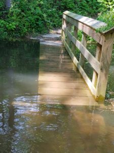
First, Watauga Lake (TVA level info) is 1965′ on 2/14 morning which is above 1961′ trigger for rerouting. Trail bridges are flooded so the trail will temporarily follow the blue blaze path along US 321 and Oliver Hollow Road. If heading trail north on Shook Branch Road, cross US 321 and walk left or west along US 321 for about a quarter mile and then go right along Oliver Hollow Rd. Follow the road for a third of a mile and take the short woods path to the right back to the A.T. If lake level continues to rise, some sections of the trail north of Oliver Hollow Road will also be under water.
Second is for Laurel Fork Gorge as the ledge along the stream is fully under water, so the A.T. will follow the High Water Trail. Signs have been posted.