Current Status:
Closure notice for the Appalachian Trail (link to Forest Order# 08-11-08-25-01) designated within the Appalachian Ranger District (ARD) of the Pisgah National Forest (PNF, North Carolina) continues to remain officially closed from Indian Grave to to Hughes Gap (AT NOBO mileage 352.9 to 374.2). While the Tennessee Eastman Hiking & Canoing Club (TEHCC) is making progress on clearing a path through this section, excessive downed timber is slated for removal north and south of Iron Mountain Gap, thus hikers are not to be in those areas for safety purposes. A shuttle will be required if the temporary bypass is not in place. Warning signs will be in displayed during the actual removal effort with potential enforcement action for who do not heed.
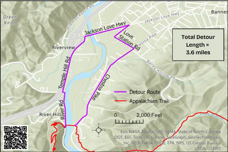
An official 3.6 mile road walk detour (refer to the separate article in this newsletter) has been established around the destroyed Chestoa Pike Bridge over Nolichucky River. It is now part of the Appalachian Trail until the bridge is replaced. FEMA announced in early February $9.77M funding to replace the bridge (link). Please be careful as the roads are not hiker-friendly, missing sidewalks with vehicle traffic on some sections.
While most of the A.T. is “Open”, it does not mean it is completely safe and/or cleared to all locations. The focus has been on the primary path, so blue blaze side trails to water sources may not be readily passable. Dead trees will continue fall. Please watch out for hazard trees at bridges, shelters, campsites, and water sources; reporting any to the club and/or forest service to give priority for removal.
Continuing Efforts:
Per the club records, during October to mid-February over 5,500 volunteer hours have been given to the recovery effort. We wish to thank the many volunteers, who are genuinely interested in participating, including experienced maintainers from other A.T. clubs and Johnson City Hiking Club. The focus remains opening the A.T. for section and thru hikers, while the subsequent priorities are to remove blowdowns from key campsites, around shelters, and on blue blaze trails to water. Please ensure at least 10-15 feet around a campfire ring is cleared as the dead brush and trees dry to become fire hazard. The club will also be repairing the deep holes in the tread caused by the many root balls pulled out of the ground; however, some work will be delayed until warmer Spring weather arrives.
Pond Mountain Wilderness between Dennis Cove Road and US321 is now open except for up on Pond Flats. In March, experienced crosscut sawyers will tackle opening what is needed for hikers. Southern Appalachian Wilderness Stewards (SAWS) will focus on the remaining five miles within Big Laurel Branch Wilderness (one mile south of the Vandeventer shelter to northern wilderness boundary).
While the trail club continues regular weekly crews with some weekend trips, the decision was made to limit event size until April due to the Winter weather. We are also guiding other groups (such as scouts) to stay off Appalachian Trail between Interstate 40 (easier reference) and Virginia but enjoy public lands to the west.