

Joe DeLoach reporting
Because of the threatening weather forecast for April 16th, we decided to postpone our Spring Wildflower Hike at [[Rock Creek Falls]] until April 17th. This worked out well, as the 17th was a beautiful day, while the 16th was stormy and windy as predicted. With 13 hikers, including many first-timers, we squeezed under the Unaka Mountain Wilderness group size limit of 14. The rainy spring made the four creek crossings a challenge, but other than wet feet, there was only one slight slip and dip. The Cherokee National Forest has worked on the trail including putting in stepping stones at each crossing, but most were under water (this was the highest water level the hike leader has seen in six trips to the falls). We saw 21 types of flowers and flowering trees, including numerous red erect trilliums, Dutchman’s breeches, squirrel corn, gay wings, trout lilies, spring beauties, and several species of violets. Our youngest hiker, 7-year old Haley Moran, also spotted some morel mushrooms within the Rock Creek Recreation Area. Joining Haley on the hike were Kelley and Blanche Moran, John Macpherson, Jacqueline Senosain, Justin Starr, Donna Ashby, Mary Fanslow, newcomer to East Tennessee Troy Greenwald, Bob Jackson, Kiernan Tonnies, and Joe DeLoach.
 Ah, a spring walk on a warm Sunday afternoon! With area temperatures reaching 87˚F, the shaded Doe River Gorge offered a comfortable hike while viewing and photographing the early wildflowers (wild ginger, yellow and wake robin trilliums, longspur, bleeding hearts, fire pink, and more). The three cars for the eight folks from TEHCC converged from different directions at the camp around 1:45. A surprise was when more cars with another 21 people pulled up at that same time. During the hike, we figured out that two hiking clubs had arrived coincidently for the same hike. Thus the trip was enjoyed with the “Little Lost Hikers” from Linville, NC (including some Boy Scouts from two troops). A real benefit was their wildflower expert who helped with identification. (FYI, looks like more flowers would be in bloom in early to mid-May.) The 5-mile hike was completed in roughly three hours. From TEHCC were Troy Greenwald, his daughter Ella, and mother Joan Amato, Sharon Burnette, Solange Adams, Serita Blankenbecler, and Cinda Foglesong.
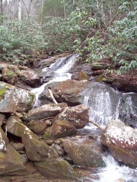
 Located north of Big Stone Gap, VA, the Roaring Branch Trail is within the Jefferson National Forest. This hike ended up being 8 miles round trip with ~1400 ft elevation change requiring six and half hours to complete. The trail starts at the cascades (see photo), proceeds up the lush valley to the ridgeline, which is followed to the High Butte overlook. There are multiple stream crossings – mostly rock hopping, but one did end up needing to be waded. Blowdowns from the winter 2009 storms in the first 1.5 miles have been cleared by volunteers (per Forest Service ranger). The mid section, still along the creek, had not yet been maintained to remove several small tree falls plus trim back the rhododendron growth, thus required a few detours and lots of hand clipping. The upper section, emerging onto the ridge crest, changed to more open forest. At the overlook, lunch and the sunny day were enjoyed while peering down into Powell Valley. The return trip, downhill and with a more open path, was quick. Not much active wildlife was seen, except for several species of birds and a small snake on a rock in the trail. Out for the nearly spring day were Vic, Clark, and Ben Hasler. For more details, visit the TEHCC Trail Wiki’s entry for [[Roaring Branch Trail]].