Trip Report: Rocky Fork White House Cliffs

Tim McClain Reporting
Sunday July 13, 2014

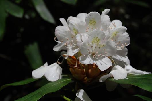
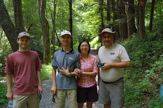
The first thing we saw when arriving at the Rocky Fork parking area was a whole lot of cars – a rare sight for this area! The second thing we saw, and the explanation for all the parked cars, was a church group gathered at the creek bank for a baptism surrounded by some of the prettiest scenery for many miles. After finding our own parking spots, five of us made the relatively short but steep trek to the top of the first high point inside Tennessee’s newest State Park. The weather was hot and muggy, but rhododendrons were still blooming in the shady forest. A branch trail, which is on the right about 1/2 mile up the main trail from the parking area, leads up the White House Cliffs. The route has some flags marking the way, but it is by no means a well-established trail. Vic Hasler turned this hike into somewhat of a work trip too as he brought clippers and a GPS to get the trail route recorded in his GPS (to be posted on our Trail Wiki). Vic also was able to locate 3 or 4 geocaches along the trail. Those participating in the hike were Vic Hasler, William Werner, Jianhui Zhou, Xiaofang Dong, and Tim McClain. This hike would also be a great fall color hike as the destination provides a very rewarding 360 degree view from the top (approximately 3300 ft elevation).

Fresh Bear Tracks!
Fresh Bear Tracks!
Left to Right: Tim McClain, Xiaofang Dong, William Werner, Vic Hasler
2014-07 White House Cliffs 02
Left to Right: William Werner, Jianhui Zhou, Xiaofang Dong, Vic Hasler

Trip Report: Laurel Falls from Dennis Cove – July 6th

We were blessed with a very comfortable Sunday afternoon for our 2.6 mile round-trip hike to Laurel Falls. This is a very family-friendly hike with the only somewhat challenging part being the actual walk down and back from the waterfall. This path is make of large stepping stones some of which are easier to navigate than others. But with reasonable care the route is well worth the reward.

There was a decent amount of flow over the falls, but the water level was lower than I had seen it before. Lydia and Paul enjoyed cooling their heels in the creek and several other hikers at the falls were swimming. Extreme care should be taken in the water below the falls since a father and son tragically lost their lives here in July, 2012. There is a small plaque in their memory attached to a rock at the bottom of the steps. Probably the most excitement today came from watching some swimmers (not part of our group) try to capture/kill(?) a small water snake of some kind. We weren’t close enough to tell what kind it was, but they were approaching it like it was a man-eating python. The snake eventually made its escape swimming on down the creek.

Our hiking group consisted of Chris Garrett, Patti Garrett, Lydia Garrett, Paul Garrett, Leticia Brock, Beverly Griggs and Barry Griggs

Buffalo Mountain Park, White Rock Overlook – November 17, 2013

Barry Griggs reporting
Under dry but threatening skies, four dedicated hikers decided to forge ahead and tackle the 3-mile round-trip hike to White Rocks on Buffalo Mountain. According to the forecast and radar, it was almost certain that we would get wet before we returned, but so what! About thirty minutes into the hike our weather expectations were realized as a light drizzle began to fall. The rain gradually increased in intensity and everyone donned their rain gear (those who had it) for some degree of protection. While there was a steady drizzle and some wind, it never reached the level of a downpour and there was no thunder, so we were good. We encountered one other wet group of hikers from a Johnson City church who were trying to locate their church through the fog/rain from the White Rock overlook, but no luck. Footing was a bit iffy at times with piles of wet leaves on the sometimes rather steep trail, but that just added to the adventure. After White Rocks, we decided to continue on to the communication towers and return via the Tower Ridge Trail to see some different scenery. In spite of the uncooperative weather, we had a very enjoyable hike with good company. Our group included Paula Cahill, Peng Song, William Werner and Barry Griggs.

Hike Report: Rocky Fork—Flint Creek Battle Site, Nov 10, 2013

Vic Hasler reporting
On a gorgeous, late fall, Sunday afternoon, one car carrying David Kossor, Gerald Scott, Marc Schurger, and Vic Hasler took the 50-minute drive to the trailhead arriving at 2PM. With an early 5:30PM sunset, long shadows were already creeping into the valley. Leaves thickly covered the gravel road which runs along the cascading Rocky Fork stream. Back on wintery January 10, 1789 morning, John Sevier and his men had to walk or ride horses in snow along or in the cold flow – pulling “grasshopper” field cannon with three pound balls/canister shot. A portion of the troops were also sent over Flint Mountain to close the retreat path. Upon reaching Flint Creek, we discovered that a large blowdown across the stream has been converted into a simple bridge, thus affording a quick and dry passage. The Indian encampment site was in the bottomlands where the two creeks merged. Sevier reported determining their exact location from the smoke of their campfires. The wet weather caused the gunpowder to not function, so the battle quickly evolved into hand-to-hand combat with sword and tomahawk. The encounter was no longer than an hour, leaving a “bloody field” per the governor’s report. For the hikers, we could see the regrowth forest in the lowlands, but could only imagine what occurred on that snowy morning. We hiked to the upper end where the Flint Trail continues following the creek up to the ridgeline at the A.T., and then turned back. A nice easy three-mile hike was enjoyed.  Some will be back next year to pursue fishing, and a hike to the top of White House Cliffs as a newly cut trail was observed.

Warriors Path Bike Trails – Trip Report

Tim Schaefer reporting
Event Date: November 4th, 2013
Yet another beautiful fall day for a hike. This one was a bit colder than the previous week’s hike, but still extremely pleasant. Since we had small children, we kept the distance down and did just Boneyard. The trail map said 1.9, [[WPSP Mountain Bike Trail System|our wiki]] says 2.44. I’m inclined to believe our measurement, as it took us right at two hours including the short distance to and from the loop. For those who have never considered hiking these trails because of the mention of “Bike Trails,” these are some of the nicest trails that I’ve been on in Kingsport, with great views of the park and river. All we had to do was dodge out of the way of two bicyclists for our entire hike. Not bad for such a nice hike so close to home. Joining me was my family, Paula Cahill, and family friend Amanda.

Doe River Gorge – Trip Report

Tim Schaefer reporting
Event Date: October 27th
It was a beautiful fall day for a hike along the tracks to the old train bridge. For those who haven’t ventured out here yet, it’s an extremely nice hike with great views along a narrow gage train track (i.e. flat and even grade). As always, check out our wiki for [[Doe River Gorge]] for details on the trail. Joining me was my family, Jaime and Paul Aiello, and Zhufang Liu and Jingua Yuan and their children.

Mt Rogers Short Loop Hike: Massie Gap, AT, Wilburn Ridge – Trip Report

Garry Luttrell reporting
Event Date: October 19th
Fred Mullner, Serita Blankenbecler, Paula Cahill, and Garry Luttrell enjoyed the stroll, and sometimes rock climbing, up to the summit of Wilburn Ridge. Along the way we saw lots of ponies; in fact, more than I’ve ever seen before on a day’s trip. And, we could say the same for the number of hikers, scouts, groups, dogs, etc. We sat down on the top, opened our snacks, food, and drink; and, it seemed like the wind increased and temperature fell, as if some voice was saying: it’s time for you to move on, and let someone else enjoy the great 360 degree view.

2013 Damascus Hard Core

Carl Fritz reporting

This 13th annual Damascus Hard Core event was Sunday, May 19th and Monday, May 20st.  It was preceded by the tragic event at Damascus Trail Days during the parade on Saturday when 50 people were injured by a car.  Everyone experienced more obstacles including rainy weather during the Hard Core event.  But Monday ended spectacularly with everyone happy. Continue reading “2013 Damascus Hard Core”

Erwin Greenbelt – Trip Report

Mary Fanslow reporting
Event Date: August 19th

Sharon Burnett, Mary Fanslow and Pam McBride

Sharon Burnett, Pam McBride, Scott Thomsen, and Mary Fanslow enjoyed a six-mile stroll on the Erwin Linear Trail on Sunday, August 19.  Dozens of snapping turtles at the bass ponds and a few great blue heron along Indian Creek also took advantage of the weather to sun themselves.  We walked from the trail parking lot behind McDonald’s to the park adjacent to the fish hatchery, then reversed course to the wooden bridge over the wetlands.  One of us took occasional detours from the group to inspect “interesting non-wildlife” near the trail (mechanical equipment and machinery from nearby demolition and building sites). Another one stayed after the others left to jog eight miles on the path, continuing on out to the Riverwalk area.  We all agreed the Linear Trail was worth a repeat visit.