

The prohibition on campfires within the Roan Mountain area (Hughes Gap to Doll Flats) was extended to 2030 by USFS Forest Order No. 08-11-08-25-04. Camp stoves are allowed if solely fueled by liquid petroleum or LPG fuels that can be turned on and off, the area is barren or cleared of all overhead and surrounding flammable materials within three feet. Everyone should emphasize that campfires are not be used through any areas damaged by Hurricane Helene.
AT – Hurricane Helene Recovery Update (May 2025)
Refer to May 2025 TEHCC newsletter for prior update for items that have not changed
- The lumber salvage firm continues to remove excessive downed timber from the bypassed Appalachian Trail section at Iron Mountain Gap (NOBO mileage 360.6 to 365.9). The detour (link), marked with temporary plastic white blazes and maps at each end, has been improved with many steps. USFS expects the recovery operation will continue late into the summer.
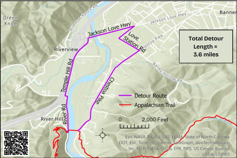
- Ferry service for hikers to cross the Nolichucky River at the Chestoa Pike bridge (link) will continue until mid-June (actual end date may a week or so later determined by time billed by the outfitter versus the grant amount). It operates between 9am to 2pm, unless inclement weather conditions pause the service. The alternative is an official 3.6 mile road walk detour (link). Please be careful as the roads are not hiker-friendly, missing sidewalks with vehicle traffic on some sections.
- Pisgah National Forest plans on opening the Roan Mountain Day Use Area by June 14th. A grand opening in August or September will occur once the roadway is repaved and a determined number dead trees (aka fuel) are removed to mitigate potential for wildfire. Note: Campfires are still banned along the AT between Hughes Gap to Doll Flats.
- First suspected case of Norovirus in the region occurred in mid-May. A hiker, complaining of moderate to severe gastrointestinal issues, was removed from the trail between the Apple House campsite (former shelter location) and Doll Flats. ATC flyer about Norovirus.
Final Volunteer Hours Report for Helene AT Recovery
Per club records from October 2024 through March 2025, trip reports for hurricane recovery activities (versus normal maintenance) has now made the 134 miles managed by TEHCC passable (with temporary detours). A total of 190 events tallied 8,043 volunteer hours (plus US Forest Service) involving 867 hours with chainsaws. Work is expected to continue throughout the Summer to widen the passageway, repair shelters, and remediate rootball damage.
Appalachian Trail – Hurricane Helene Recovery Update
Current Status:
Closure notice for the Appalachian Trail (link to Forest Order# 08-11-08-25-01) designated within the Appalachian Ranger District (ARD) of the Pisgah National Forest (PNF, North Carolina) continues to remain officially closed from Indian Grave to to Hughes Gap (AT NOBO mileage 352.9 to 374.2). While the Tennessee Eastman Hiking & Canoing Club (TEHCC) is making progress on clearing a path through this section, excessive downed timber is slated for removal north and south of Iron Mountain Gap, thus hikers are not to be in those areas for safety purposes. A shuttle will be required if the temporary bypass is not in place. Warning signs will be in displayed during the actual removal effort with potential enforcement action for who do not heed.
An official 3.6 mile road walk detour (refer to the separate article in this newsletter) has been established around the destroyed Chestoa Pike Bridge over Nolichucky River. It is now part of the Appalachian Trail until the bridge is replaced. FEMA announced in early February $9.77M funding to replace the bridge (link). Please be careful as the roads are not hiker-friendly, missing sidewalks with vehicle traffic on some sections.
While most of the A.T. is “Open”, it does not mean it is completely safe and/or cleared to all locations. The focus has been on the primary path, so blue blaze side trails to water sources may not be readily passable. Dead trees will continue fall. Please watch out for hazard trees at bridges, shelters, campsites, and water sources; reporting any to the club and/or forest service to give priority for removal.
Continuing Efforts:
Per the club records, during October to mid-February over 5,500 volunteer hours have been given to the recovery effort. We wish to thank the many volunteers, who are genuinely interested in participating, including experienced maintainers from other A.T. clubs and Johnson City Hiking Club. The focus remains opening the A.T. for section and thru hikers, while the subsequent priorities are to remove blowdowns from key campsites, around shelters, and on blue blaze trails to water. Please ensure at least 10-15 feet around a campfire ring is cleared as the dead brush and trees dry to become fire hazard. The club will also be repairing the deep holes in the tread caused by the many root balls pulled out of the ground; however, some work will be delayed until warmer Spring weather arrives.
Pond Mountain Wilderness between Dennis Cove Road and US321 is now open except for up on Pond Flats. In March, experienced crosscut sawyers will tackle opening what is needed for hikers. Southern Appalachian Wilderness Stewards (SAWS) will focus on the remaining five miles within Big Laurel Branch Wilderness (one mile south of the Vandeventer shelter to northern wilderness boundary).
While the trail club continues regular weekly crews with some weekend trips, the decision was made to limit event size until April due to the Winter weather. We are also guiding other groups (such as scouts) to stay off Appalachian Trail between Interstate 40 (easier reference) and Virginia but enjoy public lands to the west.
Official A.T. Detour for the Nolichucky River
The Chestoa Bridge was destroyed during Hurricane Helene. It was the Nolichucky River crossing for the Appalachian Trail. The USFS, TN DOT, and town of Erwin agreed to a 3.6 mile road walk detour until the bridge is rebuilt. It has been marked with white blazes as the official A.T. route temporarily.
The Appalachian Trail Conservancy is sharing these cautions:
- There is currently heavy truck traffic on Unaka Spring Rd/River Rd due to repairs to the railroad upstream. This is a narrow road with no shoulder.
- Walk on the left side of the road when possible, facing traffic.
- Wear bright colors and wear your headlamp with the light on, even during the day.
- Do not walk along roads at night.
- Walk single file; do not walk side by side
NOBO (northbound) Directions:
- Come out of the woods and turn left on Unaka Springs Rd/River Road and walk 0.5 mi to Temple Hill Rd/TN 36. You’ll walk right past Uncle Johnny’s Hostel.
- Turn right on Temple Hill Rd and follow for 0.8 mi to the Jackson Love Highway.
- Turn right on Jackson Love Highway and follow for 0.5 mi to Love Station Rd.
- Take the sharp right on Love Station Road/Carolina Ave and follow for 0.5 mi to Chestoa Pike.
- Turn right on Chestoa Pike and follow for 1.3 mi back to the other side of the washed out bridge. The A.T. heads back up into the woods to the left, off Jones Branch Rd just past the intersection.
Hurricane Helene Update (as of 10/22/2024)
All sections of the Appalachian Trail within the Pisgah National Forest (North Carolina) remain closed, specifically TEHCC Maintenance Sections 14a-16b from Doll Flats to just north of Iron Mountain Gap. North Carolina Dept. of Transportation asks the public to limit travel in Western North Carolina to essential traffic only.
Over the past three weeks, Cherokee National Forest staff, along with out-of-state crews, have been assessing the storm’s impact. On October 15, access to significant portions of the Appalachian Trail within the Cherokee National Forest was restored, though the area between US19E and US321 remains closed, specifically TEHCC Maintenance Sections 9a-12d from Shook Branch to east of Roan Mountain. The USFS warns that “portions of the Appalachian Trail remain closed or inaccessible with hundreds of trees per mile blocking the route”.
A few volunteer groups are now being organized by the club for work in Tennessee to obtain more details about access routes, trailheads, bridges, shelters, and tread damage – and perform minor maintenance activities with hand tools only. No individual should enter the forest alone.
As the situation on the ground evolves, more updates will be provided for the Appalachian Trail recovery efforts.
Roan High Knob shelter closed for repairs to be made in 2025
The Roan High Knob shelter is shifting on its foundation due to several rotting logs, thus is closed for safety reasons until extensive repairs can be made in 2025 which could take through October. The USFS closure notice also includes a 60-foot buffer for no camping around the shelter. Please stay away from the shelter which has its door bolted shut and first floor removed.
Camping is available at Ash Gap.
Forest Road 230 from Indian Grave Gap to Beauty Spot Overlook is now OPEN
USFS shares: UPDATE 8/19/2024 – Repairs to Beauty Spot Overlook are now complete. The overlook is now open.
USFS Notice for Bear Activity at Abingdon Gap Shelter
Update: A new encounter report on 5/16 about an aggressive bear at a quick gallop charging a pair of hikers two miles north of the shelter, then following for another 0.1-mile. New signs will be posted between Damascus and the shelter.
Original Post: Watauga Ranger District is hanging signs today (April 26th) on the Appalachian Trail at US421, McQueen Gap, at the shelter and maybe in Damascus warning about reported bear activity at Abingdon Gap Shelter. This notice is NOT a camping closure as experienced during the past few years, but a warning to alert hikers. (It could later escalate.)
A small/ young bear chewed on a secured Ursack and moved two bear canisters. It was observed again on the following night hanging around the shelter. Bear was not intimidated with yelling, waving, and clapping.
The posted signage asks hikers to hang all food (including canisters) if they are going to be at the shelter.
Refer to the prior posts about bear activity for recommendations… best would be to not camp in the Abingdon Gap Shelter or nearby site.