Warriors' Path State Park: Difference between revisions
(change lodging camping to campground) |
m (Refine MB trail system query and get rid of redlink stub search) |
||
| (25 intermediate revisions by the same user not shown) | |||
| Line 1: | Line 1: | ||
{{Park | {{Park | ||
|Banner Image=File:Warriors' Path State Park Banner.jpg | |||
|Park Type=State Park | |Park Type=State Park | ||
|Park Website=https://tnstateparks.com/parks/warriors-path | |Park Website=https://tnstateparks.com/parks/warriors-path | ||
|Trail Map Link=https://tnstateparks.com/assets/pdf/additional-content/park-maps/41-warriors-path.jpg | |Trail Map Link=https://tnstateparks.com/assets/pdf/additional-content/park-maps/41-warriors-path.jpg | ||
|Activities=Hiking | |Entrance Fee= | ||
|Entrance Fee Type=None | |||
|Activities=Hiking, Boating, Biking, Geocaching, Horses, Fishing | |||
|Features=Waterfalls, Vistas, Rivers, Lakes | |Features=Waterfalls, Vistas, Rivers, Lakes | ||
|Park Amenities=Golf, Disc Golf, Pools, Fast Food Grill, Beaches, Sports, Picnicking, Playgrounds | |||
|Park Trail Count= | |||
|Park Trail Miles= | |||
|Lodging Types=Campground | |Lodging Types=Campground | ||
|Camping Amenities=Site water, Dump station, | |Camping Amenities=Site water, Dump station, 20 amp electrical, 30 amp electrical, 50 amp electrical, Showers, Playgrounds, Wi-Fi, Camp Store | ||
|City=Kingsport | |City=Kingsport | ||
|Area=950 acres | |Area=950 acres | ||
|Operated By=Tennessee Department of Environment and Conservation | |Operated By=Tennessee Department of Environment and Conservation | ||
|Main Location=36.49857, -82.48675 | |||
|Parking=36.49856, -82.48659 | |Parking=36.49856, -82.48659 | ||
}} | }} | ||
{{Park trail map}} | {{Park trail map}} | ||
| Line 38: | Line 43: | ||
== Park Trails == | == Park Trails == | ||
<!-- A little wizardry here. We wanted to subgroup the trails list. Wanted to list the "Trail System" defined MB trails separately. Unfortunately there is no way to ask for a property undefined. Instead did array operations. (All Trails)-(MB Trails)=(Trails not part of system). Could have just done listed trail names, but it would need updating with trail name changes (unlikely). | |||
-->{{#ask:[[Category:Trail||Trails]] [[Park::{{PAGENAME}}]] | |||
|format=array | |||
|link=none | |||
|name = allTrails | |||
}}{{#ask:[[Category:Trail||Trails]] [[Park::{{PAGENAME}}]] [[Trail System::~*Mountain Bike*]] | |||
|format=array | |||
|link=none | |||
|name = systemTrails | |||
}}{{#arraydiff:mainTrails|allTrails|systemTrails}} | |||
The park offers the following trails to explore: | The park offers the following trails to explore: | ||
{{Park trail table template|#userparam=intro}} | |||
{{Park trail table|Park={{ | {{Park trail table template|#userparam=header|header=Main Park Trails}} | ||
{{#ask:[[Category:Trail||Trails]] [[Park::{{PAGENAME}}]] [[{{#arrayprint:mainTrails|{{!}}{{!}}}}]] | |||
|mainlabel=trail | |||
| ?Trail Distance#mi-p2=distance | |||
| ?Difficulty=difficulty | |||
| ?Trail Marking=marking | |||
| ?Trail Highlight=highlight | |||
| ?Allowed activities=use | |||
|format=plainlist | |||
|headers=hide | |||
|link=none | |||
|template=Park trail table template | |||
|userparam=row | |||
|named args=yes | |||
}} | |||
{{Park trail table template|#userparam=header|header=Mountain Bike Trail System}} | |||
{{#ask:[[Category:Trails]] [[Trail System::Warriors' Path State Park Mountain Bike Trails]] | |||
|mainlabel=trail | |||
| ?Trail Distance#mi-p2=distance | |||
| ?Difficulty=difficulty | |||
| ?Trail Marking=marking | |||
| ?Trail Highlight=highlight | |||
| ?Allowed activities=use | |||
|format=plainlist | |||
|headers=hide | |||
|link=none | |||
|template=Park trail table template | |||
|userparam=row | |||
|named args=yes | |||
}} | |||
{{Park trail table template|#userparam=outro}} | |||
'''Note:''' Technically Wahoo is not within the park, but is on TVA land accessed through the park as part of the Mountain Bike trail system. | |||
A couple mile loop around most of the park campground can be done on Lake Hollow, Connector, and Lakeshore trails. | A couple mile loop around most of the park campground can be done on Lake Hollow, Connector, and Lakeshore trails. | ||
| Line 52: | Line 98: | ||
=== Campground === | === Campground === | ||
Campground has bath houses spread around the park, including showers. Two dump stations are available at the front and rear of the campground. | Campground has bath houses spread around the park, including showers. Two dump stations are available at the front and rear of the main campground. | ||
The "Overflow Campground" is currently being renovated for previously announced RV friendly sites including site sewer. Work began in December 2020. | |||
A Hammock campground was added late 2020, presumably for reservation starting in 2021. It appears to be hammock only. | |||
==Other Park Amenities== | ==Other Park Amenities== | ||
| Line 91: | Line 141: | ||
== Misc. Information == | == Misc. Information == | ||
<!-- Enter any additional information that doesn't fit an any other fields. Any seasonal features, factoids, etc...? --> | <!-- Enter any additional information that doesn't fit an any other fields. Any seasonal features, factoids, etc...? --> | ||
Formally a Tennessee Valley Authority park. | Formally a Tennessee Valley Authority (TVA) park. | ||
The park name is "plural possessive." It is the path of multiple Warriors. | |||
In 2019 a major renovation program was announced by the park as part of a $6 million program. Renovations include upgrading the water main, building a new marina with dock and covered slips, transforming the recreation hall on Duck Island into the park headquarters and visitors center, and modify the overflow campground to be better suited to modern large RV's. Work is expected to begin in 2020. No statement of completion time frame. | |||
==Gallery== | ==Gallery== | ||
{{Park trail gallery|Park={{PAGENAME}}}} | {{Park trail gallery|Park={{PAGENAME}}}} | ||
{{Map Marker | |||
|Icon Type=Ranger Station | |||
|Marker Title=Ranger Station | |||
|Marker Description= | |||
|Marker Location=36.498556,-82.486761 | |||
}} | |||
{{Map Marker | {{Map Marker | ||
|Icon Type=Playground | |Icon Type=Playground | ||
| Line 110: | Line 170: | ||
|Icon Type=Other photo spot | |Icon Type=Other photo spot | ||
|Marker Title=High Point of Park (1,660 ft) | |Marker Title=High Point of Park (1,660 ft) | ||
|Marker Description= | |||
|Marker Location=36.496804, -82.465246 | |Marker Location=36.496804, -82.465246 | ||
}} | }} | ||
| Line 115: | Line 176: | ||
|Icon Type=Photo spot | |Icon Type=Photo spot | ||
|Marker Title=Overlook | |Marker Title=Overlook | ||
|Marker Description= | |||
|Marker Location=36.50065, -82.47918 | |Marker Location=36.50065, -82.47918 | ||
}} | }} | ||
{{Map Marker | {{Map Marker | ||
|Icon Type=Photo spot | |Icon Type=Photo spot | ||
|Marker Title=Overlook | |Marker Title=Lone Cedar Overlook | ||
|Marker Description=[[Image:Devils backbone view from lone cedar lookout.jpg|150px|View from Lone Cedar Overlook]] | |||
|Marker Location=36.50013, -82.4776 | |Marker Location=36.50013, -82.4776 | ||
}} | }} | ||
| Line 125: | Line 188: | ||
|Icon Type=Overlook | |Icon Type=Overlook | ||
|Marker Title=Overlook | |Marker Title=Overlook | ||
|Marker Description= | |||
|Marker Location=36.48795, -82.47944 | |Marker Location=36.48795, -82.47944 | ||
}} | }} | ||
| Line 130: | Line 194: | ||
|Icon Type=Overlook | |Icon Type=Overlook | ||
|Marker Title=Overlook | |Marker Title=Overlook | ||
|Marker Description= | |||
|Marker Location=36.48719, -82.47995 | |Marker Location=36.48719, -82.47995 | ||
}} | }} | ||
| Line 135: | Line 200: | ||
|Icon Type=Trail bridge | |Icon Type=Trail bridge | ||
|Marker Title=Bridge | |Marker Title=Bridge | ||
|Marker Description= | |||
|Marker Location=36.50051, -82.47105 | |Marker Location=36.50051, -82.47105 | ||
}} | }} | ||
| Line 140: | Line 206: | ||
|Icon Type=Trail bridge | |Icon Type=Trail bridge | ||
|Marker Title=Bridge | |Marker Title=Bridge | ||
|Marker Description= | |||
|Marker Location=36.50294, -82.4688 | |Marker Location=36.50294, -82.4688 | ||
}} | }} | ||
| Line 145: | Line 212: | ||
|Icon Type=Trail bridge | |Icon Type=Trail bridge | ||
|Marker Title=Bridge | |Marker Title=Bridge | ||
|Marker Description= | |||
|Marker Location=36.4979050143, -82.4792440347 | |Marker Location=36.4979050143, -82.4792440347 | ||
}} | }} | ||
| Line 150: | Line 218: | ||
|Icon Type=Trail bridge | |Icon Type=Trail bridge | ||
|Marker Title=Bridge | |Marker Title=Bridge | ||
|Marker Description= | |||
|Marker Location=36.49731, -82.47734 | |Marker Location=36.49731, -82.47734 | ||
}} | }} | ||
| Line 155: | Line 224: | ||
|Icon Type=Bench | |Icon Type=Bench | ||
|Marker Title=Girl Power Bench | |Marker Title=Girl Power Bench | ||
|Marker Description= | |||
|Marker Location=36.49665, -82.47565 | |Marker Location=36.49665, -82.47565 | ||
}} | }} | ||
| Line 160: | Line 230: | ||
|Icon Type=Bench | |Icon Type=Bench | ||
|Marker Title=Ulster Project Benches | |Marker Title=Ulster Project Benches | ||
|Marker Description= | |||
|Marker Location=36.50252, -82.46827 | |Marker Location=36.50252, -82.46827 | ||
}} | }} | ||
| Line 165: | Line 236: | ||
|Icon Type=Water crossing | |Icon Type=Water crossing | ||
|Marker Title=Creek Crossing | |Marker Title=Creek Crossing | ||
|Marker Description= | |||
|Marker Location=36.50137, -82.46522 | |Marker Location=36.50137, -82.46522 | ||
}} | }} | ||
| Line 170: | Line 242: | ||
|Icon Type=Water crossing | |Icon Type=Water crossing | ||
|Marker Title=Sinking Creek | |Marker Title=Sinking Creek | ||
|Marker Description= | |||
|Marker Location=36.51033916, -82.48117222 | |Marker Location=36.51033916, -82.48117222 | ||
}} | }} | ||
| Line 175: | Line 248: | ||
|Icon Type=Point of interest | |Icon Type=Point of interest | ||
|Marker Title=Warriors' Path Riding Stables | |Marker Title=Warriors' Path Riding Stables | ||
|Marker Description= | |||
|Marker Location=36.5079432419, -82.4846941996 | |Marker Location=36.5079432419, -82.4846941996 | ||
}} | }} | ||
| Line 180: | Line 254: | ||
|Icon Type=Parking | |Icon Type=Parking | ||
|Marker Title=Parking | |Marker Title=Parking | ||
|Marker Description= | |||
|Marker Location=36.5165097571, -82.4735671041 | |Marker Location=36.5165097571, -82.4735671041 | ||
}} | }} | ||
| Line 185: | Line 260: | ||
|Icon Type=Trail bridge | |Icon Type=Trail bridge | ||
|Marker Title=Bridge | |Marker Title=Bridge | ||
|Marker Description= | |||
|Marker Location=36.51633035, -82.47422936 | |Marker Location=36.51633035, -82.47422936 | ||
}} | }} | ||
| Line 190: | Line 266: | ||
|Icon Type=Trail bridge | |Icon Type=Trail bridge | ||
|Marker Title=Metal Walkway | |Marker Title=Metal Walkway | ||
|Marker Description= | |||
|Marker Location=36.51068165, -82.48150341 | |Marker Location=36.51068165, -82.48150341 | ||
}} | }} | ||
Latest revision as of 11:59, 19 September 2021
| Warriors' Path State Park | |
|---|---|

| |
| Park Type | State Park |
| Located | Kingsport, Tennessee |
| External Links | Official Website |
| Entrance Fee | None |
| ActivitiesThings to do at the park | |
| Park AmenitiesThings built to enjoy or use at the park | |
| FeaturesNatural things to see at the park | |
| Park Trails |
24 Trails / Total of 17.84 miles28.711 km <br /> |
| Lodging Types | |
| Camping Amenities |
|
| Park Area | 950 acres3.845 km² <br /> |
| Operated By | Tennessee Department of Environment and Conservation |
| Main Location | 36° 29' 54.85" N, 82° 29' 12.30" W Map |
|
| |
| Show In Google Maps | |
Download KML / Upload new version / KML File Page
Park Overview[edit]
Warrior's Path State Park has 24 trails covering 17.84 miles good for quick after work jaunts with the kids and pets for a quick stroll.
How to get there[edit]
The park address is 490 Hemlock Road, Kingsport, Tennessee 37663
From downtown Kingsport, TN:
- Take Fort Henry Drive/TN-36 toward Colonial Heights.
- Turn left at stoplight by Food City onto Hemlock Road. (Warning: Red Light camera intersection this direction.)
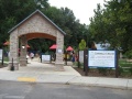
- Follow Hemlock Road under railroad underpass. The park ranger station is just inside the main entrance.
From I-81:
- Take TN Exit 59 (Kingsport).
- Turn NW on Fort Henry Drive/TN-36.
- Turn right (north) onto Colonial Heights (by Zoomerz, Sunoco). (Warning: Red Light camera intersection in this direction. Come to a complete stop if the light is yellow or red before making turn.)
- Continue on Colonial Heights road as it makes a sharp left and then right over railroad tracks.
- Turn right (east) on Hemlock Road. The main park entrance can be seen.
Trailheads are in several different locations, so refer to the specific trail descriptions.
Park Trails[edit]
The park offers the following trails to explore:
| Park Trails | Distance | Difficulty | Marking | Usage | Highlight |
|---|---|---|---|---|---|
| Main Park Trails | |||||
| Connector | 0.28 mi | Easy | None |
|
|
| Devil's Backbone | 1.20 mi | Medium | Red |
|
|
| Fall Creek Loop | 0.92 mi | Medium | Orange |
|
|
| Holston Bluffs | 0.38 mi | Easy | White |
|
|
| Lake Hollow | 0.56 mi | Easy | None |
|
|
| Lakeshore | 0.31 mi | Easy | Black |
|
|
| Overlook | 0.73 mi | Easy | None |
|
|
| Riverbank | 0.24 mi | Easy | Blue |
|
|
| Sinking Waters | 1.75 mi | Easy | Green, Yellow, Blue |
|
Three connected loops and a stream that disappears into a sinkhole |
| Woodland Ridge | 0.78 mi | Medium | None |
|
|
| Mountain Bike Trail System | |||||
| Boneyard | 2.33 mi | Medium | Black Triangle |
|
|
| Boneyard Connector | 0.04 mi | Easy | None |
|
|
| Darwin's Connector | 0.10 mi | Easy | None |
|
|
| Darwin's Revenge | 2.06 mi | Medium | Black Diamond |
|
|
| Fawn Loop | 0.61 mi | Easy | Yellow |
|
|
| Lake Road | 0.84 mi | Easy | None |
|
The main trail artery of the Mountain Bike System |
| Magic Carpet Ride | 0.20 mi | Medium | None |
|
|
| Pawpaw | 0.56 mi | Medium | Blue |
|
Half mile loop that can be added to Lake Road or connect with Whitetail |
| Pawpaw Connector | 0.10 mi | Easy | None |
|
|
| Ridge Top | 0.48 mi | Hard | None |
|
|
| Rock City | 0.50 mi | Medium | Black |
|
|
| Wahoo | 1.72 mi | Medium | None |
|
|
| Whitetail Alternate | 0.20 mi | Medium | None |
|
|
| Whitetail Loop | 2.31 mi | Medium | Blue Triangle |
|
One of the three main loops of the mountain bike trails |
| Zipline | 0.35 mi | Easy | None |
|
Alternate to/from other trails rather than using Lake Road |
Note: Technically Wahoo is not within the park, but is on TVA land accessed through the park as part of the Mountain Bike trail system.
A couple mile loop around most of the park campground can be done on Lake Hollow, Connector, and Lakeshore trails.
Devil's Backbone and Fall Creek Loop trails also make a nice combination.
Riverbank Trail no longer connects across Fall Creek Road with Holston Bluffs Trail.
Park Lodging[edit]
Park offers 134 camping sites. All of which allows either tents or RV's. Sites fill up quickly on most summer weekends. It is ill advised to arrive without a reservation in the summer.
Campground[edit]
Campground has bath houses spread around the park, including showers. Two dump stations are available at the front and rear of the main campground.
The "Overflow Campground" is currently being renovated for previously announced RV friendly sites including site sewer. Work began in December 2020.
A Hammock campground was added late 2020, presumably for reservation starting in 2021. It appears to be hammock only.
Other Park Amenities[edit]
- Pool
- Golf Course
- Playgrounds
- Amphitheater
- Picnic areas
- Pavilions
- Tennis courts
- Boat launches
- Marina with restaurant
- Soccer fields
- Disc golf
- Basketball court
- Horseback riding stables
Fees, Permits, etc.[edit]
The park has no day use, trail head, or entrance fees.
Camping fees range from $11-$20 per night depending on time of year and site amenities plus a $3 per reservation fee and taxes. Reservations can be made at their website.
Dining[edit]
Inside the marina is a snack bar offering select grill items, drinks, and other standard small store concessions.
Seasonal Events[edit]
- Winter Gardening Seminar
- Spring Nature Festival
- Dragonfly Day
- Summer in the Park
- Folklife Festival
- Environmental Education Workshop
- Adopt a Tree
- Christmas on the Lake
- Recreation and Nature Activities
Misc. Information[edit]
Formally a Tennessee Valley Authority (TVA) park.
The park name is "plural possessive." It is the path of multiple Warriors.
In 2019 a major renovation program was announced by the park as part of a $6 million program. Renovations include upgrading the water main, building a new marina with dock and covered slips, transforming the recreation hall on Duck Island into the park headquarters and visitors center, and modify the overflow campground to be better suited to modern large RV's. Work is expected to begin in 2020. No statement of completion time frame.
Gallery[edit]
Darrel's Dream playground
Soccer Fields Sign
Warriors Drive Welcome Sign
Hemlock Welcome Sign


