Loading map...
{"format":"googlemaps3","type":"TERRAIN","minzoom":false,"maxzoom":false,"types":["SATELLITE","HYBRID","TERRAIN"],"limit":50,"offset":0,"link":"none","sort":[""],"order":[],"headers":"show","mainlabel":"","intro":"","outro":"","searchlabel":"... further results","default":"","import-annotation":false,"width":"auto","height":"600px","centre":false,"title":"","label":"","icon":"","lines":[],"polygons":[],"circles":[],"rectangles":[],"copycoords":false,"static":false,"visitedicon":"","wmsoverlay":false,"zoom":false,"layers":[],"controls":["pan","zoom","type","scale","streetview","rotate"],"zoomstyle":"DEFAULT","typestyle":"DEFAULT","autoinfowindows":false,"resizable":false,"kmlrezoom":true,"poi":true,"cluster":false,"clustergridsize":60,"clustermaxzoom":20,"clusterzoomonclick":true,"clusteraveragecenter":true,"clusterminsize":2,"imageoverlays":[],"kml":[],"gkml":["https://tehcc.org/clubwiki/images/Lakeshore.kml","https://tehcc.org/clubwiki/images/Riverbank.kml"],"searchmarkers":"","fullscreen":false,"scrollwheelzoom":false,"showtitle":false,"hidenamespace":true,"template":"Map Balloon Template","userparam":"","activeicon":"","pagelabel":false,"ajaxcoordproperty":"","ajaxquery":"","locations":[{"text":"\u003Cp\u003E\u003Cb\u003E\u003Ca href=\"/wiki/Lakeshore\" title=\"Lakeshore\"\u003ELakeshore\u003C/a\u003E\u003C/b\u003E\u003Cbr /\u003E\u003C/p\u003E\u003Chr /\u003E\u003Cp\u003E0.31\u0026#160;Mi (0.50\u0026#160;km)\u003Cbr /\u003EDifficulty: Easy\u003Cbr /\u003EMarking: Black\u003C/p\u003E","title":"Lakeshore","link":"","lat":36.49705000000000154614099301397800445556640625,"lon":-82.4783800000000013596945791505277156829833984375,"icon":"/clubwiki/images/MarkerT.png"},{"text":"\u003Cp\u003E\u003Cb\u003ETrailhead by boat launch\u003C/b\u003E\u003Cbr /\u003E\u003C/p\u003E\u003Chr /\u003E\u003Cp\u003ETrailhead by boat launch\u003C/p\u003E","title":"Lakeshore","link":"","lat":36.4986999999999994770405464805662631988525390625,"lon":-82.482249999999993406163412146270275115966796875,"icon":"/clubwiki/images/MarkerA.png"},{"text":"\u003Cp\u003E\u003Cb\u003ETrailhead in park campground by sites B-34/35\u003C/b\u003E\u003Cbr /\u003E\u003C/p\u003E\u003Chr /\u003E\u003Cp\u003ETrailhead in park campground by sites B-34/35\u003C/p\u003E","title":"Lakeshore","link":"","lat":36.49705000000000154614099301397800445556640625,"lon":-82.4783800000000013596945791505277156829833984375,"icon":"/clubwiki/images/MarkerA.png"},{"text":"\u003Cp\u003E\u003Cb\u003EIntersection Lakeshore and Connector Trails\u003C/b\u003E\u003Cbr /\u003E\u003C/p\u003E\u003Chr /\u003E\u003Cp\u003E\u003Ca href=\"/wiki/File:WPSP_-_Sign_at_Lakeshore_and_Connector_Trail_intersection.JPG\" class=\"image\"\u003E\u003Cimg alt=\"WPSP - Sign at Lakeshore and Connector Trail intersection.JPG\" src=\"/clubwiki/images/thumb/WPSP_-_Sign_at_Lakeshore_and_Connector_Trail_intersection.JPG/150px-WPSP_-_Sign_at_Lakeshore_and_Connector_Trail_intersection.JPG\" decoding=\"async\" width=\"150\" height=\"88\" srcset=\"/clubwiki/images/thumb/WPSP_-_Sign_at_Lakeshore_and_Connector_Trail_intersection.JPG/225px-WPSP_-_Sign_at_Lakeshore_and_Connector_Trail_intersection.JPG 1.5x, /clubwiki/images/thumb/WPSP_-_Sign_at_Lakeshore_and_Connector_Trail_intersection.JPG/300px-WPSP_-_Sign_at_Lakeshore_and_Connector_Trail_intersection.JPG 2x\" data-file-width=\"448\" data-file-height=\"264\" /\u003E\u003C/a\u003E\u003C/p\u003E","title":"Lakeshore","link":"","lat":36.49741000000000212821760214865207672119140625,"lon":-82.4776399999999938472683425061404705047607421875,"icon":"/clubwiki/images/MarkerG.png"},{"text":"\u003Cp\u003E\u003Cb\u003ETrail bridge\u003C/b\u003E\u003Cbr /\u003E\u003C/p\u003E\u003Chr /\u003E\u003Cp\u003ETrail bridge\u003C/p\u003E","title":"Lakeshore","link":"","lat":36.49788000000000209865902434103190898895263671875,"lon":-82.4792599999999964666130836121737957000732421875,"icon":"/clubwiki/images/MarkerL.png"},{"text":"\u003Cp\u003E\u003Cb\u003EFishing point\u003C/b\u003E\u003Cbr /\u003E\u003C/p\u003E\u003Chr /\u003E\u003Cp\u003EFishing point\u003C/p\u003E","title":"Lakeshore","link":"","lat":36.49786999999999892452251515351235866546630859375,"lon":-82.4790600000000040381564758718013763427734375,"icon":"/clubwiki/images/MarkerG.png"},{"text":"\u003Cp\u003E\u003Cb\u003EOld dock\u003C/b\u003E\u003Cbr /\u003E\u003C/p\u003E\u003Chr /\u003E\u003Cp\u003EOld dock\u003C/p\u003E","title":"Lakeshore","link":"","lat":36.49849999999999994315658113919198513031005859375,"lon":-82.4811299999999931742422631941735744476318359375,"icon":"/clubwiki/images/MarkerG.png"},{"text":"\u003Cp\u003E\u003Cb\u003E\u003Ca class=\"mw-selflink selflink\"\u003ERiverbank\u003C/a\u003E\u003C/b\u003E\u003Cbr /\u003E\u003C/p\u003E\u003Chr /\u003E\u003Cp\u003E0.24\u0026#160;Mi (0.39\u0026#160;km)\u003Cbr /\u003EDifficulty: Easy\u003Cbr /\u003EMarking: Blue\u003C/p\u003E","title":"Riverbank","link":"","lat":36.4986999999999994770405464805662631988525390625,"lon":-82.482249999999993406163412146270275115966796875,"icon":"/clubwiki/images/MarkerT.png"},{"text":"\u003Cp\u003E\u003Cb\u003ETrailhead at Fall Creek Road\u003C/b\u003E\u003Cbr /\u003E\u003C/p\u003E\u003Chr /\u003E\u003Cp\u003ETrailhead at Fall Creek Road\u003C/p\u003E","title":"Riverbank","link":"","lat":36.50057000000000329009708366356790065765380859375,"lon":-82.4857999999999975671016727574169635772705078125,"icon":"/clubwiki/images/MarkerG.png"},{"text":"\u003Cp\u003E\u003Cb\u003ETrailhead by boat launch\u003C/b\u003E\u003Cbr /\u003E\u003C/p\u003E\u003Chr /\u003E\u003Cp\u003ETrailhead by boat launch\u003C/p\u003E","title":"Riverbank","link":"","lat":36.4986999999999994770405464805662631988525390625,"lon":-82.482249999999993406163412146270275115966796875,"icon":"/clubwiki/images/MarkerT.png"}]}
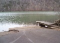
Path follows the north shoreline below the main park campground. There are dark blue trail blazes. Sometimes the route splits into an upper and lower path due to folks working their way along the steep hillside. At boat launch, can continue onto Lakeshore Trail. And right below Fall Creek Road at the bridge is an extremely popular fishing spot.
Well worn path with detours as the trees fall.
No fee required.
The park map brochure (link below) incorrectly states 0.5 mile trail length versus 0.31 mile actual/sign information.