Zipline
Jump to navigation
Jump to search
| Zipline (log in to submit report) | |
|---|---|

| |
| Highlight | Alternate to/from other trails rather than using Lake Road |
| Trail System | Warriors' Path State Park Mountain Bike Trails |
| Park | Warriors' Path State Park |
| Located | Kingsport, TennesseeLocation inherited from associated park |
| Trail Marking | None |
| Trail UseThings allowed to do on or near the trail |
|
| FeaturesThings to see on or near the trail |
|
| Difficulty Rating | Easy |
| Hiking TimeTime from car and back. Includes any time hiking to access this trail. | 30 min0.5 Hours <br />0.0313 Days <br /> round trip |
| Distance: | 0.35300.353 Mi <br />0.568 km <br /> trailStrict non-repeating trail length / 0.9 mi1.448 km <br /> round tripTypical or shortest length from the car, hike the trail, and return to car |
| Trail Type | Segment |
| Low / High Point | 1,372 ft457.333 Yards <br />418.186 Meters <br /> / 1,454 Ft484.667 Yards <br />443.179 Meters <br /> |
| Elev. Gain/LossSee link for details of calculation. Gain/Loss is direction dependent. | 76 Ft23.165 Meters <br /> / (0 Ft0 Meters <br />) – North-to-South |
| Trip ReportsFrom user "hiked it" submissions<br />Recent is within last 90 days | 1 logged hikes (0 recent) |
| NearbyWithin 5 mi<br />Click link to view list | 24 trails / 19.2 mi of trail |
| Parking | 36° 29' 31.67" N, 82° 28' 6.85" W Map |
| Trailhead | 36° 29' 36.49" N, 82° 28' 18.12" W Map |
|
| |
| Show In Google Maps | |
Download KML / Upload new version / KML File Page / Create Profile Chart / gpsvisualizer Map
Trail Overview[edit]
Located in Warriors Path State Park.
How to get there[edit]
From main entrance of Warriors Path State Park:
- Go north on Fall Creek Road for 2.4 miles.
- Turn right (east) onto Old Mill Road for 0.8 miles.
- Turn right (south) onto Childress Ferry Road for just roughly 100 yards.
- Turn left (east) onto Buttermilk Road for 1.2 miles.
- Turn right (south) onto Freeman Road for 0.5 mile.
- Continue when road changes from asphalt to gravel.
Trailhead at gravel parking lot.
Route Description[edit]

Typical Conditions[edit]
The mountain biking association SORBA Tri-Cities handles the trail maintenance, thus generally in good condition. While there are no blazes to guide you through the forest, the narrow single tracks are well established. Grab a trail map at the parking lot kiosk to help you decipher intersections; some which could use signs. Be aware for approaching bike riders who can come up quickly on your group. Step aside to let them safely pass.
Photos[edit]
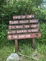
Signs at main trail split

Trail Profile