| Connector
(log in to submit report)
|
|
|
|
| Park
|
Warriors' Path State Park
|
| Located
|
Kingsport, TennesseeLocation inherited from associated park
|
| Trail Marking
|
None
|
| Trail UseThings allowed to do on or near the trail
|
 
|
| FeaturesThings to see on or near the trail
|
|
| Difficulty Rating
|
Easy
|
| Hiking TimeTime from car and back. Includes any time hiking to access this trail.
|
15 min0.25 Hours <br />0.0156 Days <br /> round trip
|
| Distance:
|
0.28 mi0.451 km <br /> trailStrict non-repeating trail length / 0.6 Mi0.966 km <br /> round tripTypical or shortest length from the car, hike the trail, and return to car
|
| Trail Type
|
Segment
|
| Low / High Point
|
1,265 ft421.667 Yards <br />385.572 Meters <br /> / 1,285 Ft428.333 Yards <br />391.668 Meters <br />
|
| Elev. Gain/LossSee link for details of calculation. Gain/Loss is direction dependent.
|
0 ft0 Meters <br /> / (-20 ft-6.096 Meters <br />) – South-to-North
|
| Trip ReportsFrom user "hiked it" submissions<br />Recent is within last 90 days
|
2 logged hikes (0 recent)
|
| NearbyWithin 5 mi<br />Click link to view list
|
24 trails / 19.3 mi of trail
|
| Parking
|
36° 29' 45.92" N, 82° 28' 39.86" W Map
|
| Trailhead
|
36° 29' 43.04" N, 82° 28' 35.26" W Map
|
Loading map... {"type":"ROADMAP","minzoom":false,"maxzoom":false,"types":["ROADMAP","SATELLITE","HYBRID","TERRAIN"],"mappingservice":"googlemaps3","width":"100%","height":"180px","centre":false,"title":"","label":"","icon":"","lines":[],"polygons":[],"circles":[],"rectangles":[],"copycoords":false,"static":false,"visitedicon":"","wmsoverlay":false,"zoom":8,"layers":[],"controls":[""],"zoomstyle":"DEFAULT","typestyle":"DEFAULT","autoinfowindows":false,"resizable":false,"kmlrezoom":false,"poi":true,"cluster":false,"clustergridsize":60,"clustermaxzoom":20,"clusterzoomonclick":true,"clusteraveragecenter":true,"clusterminsize":2,"imageoverlays":[],"kml":[],"gkml":[],"searchmarkers":"","fullscreen":false,"scrollwheelzoom":false,"locations":[{"text":"\u003Cb\u003E\u003Cdiv class=\"mw-parser-output\"\u003E\u003Cp\u003EConnector\n\u003C/p\u003E\u003C/div\u003E\u003C/b\u003E\u003Cdiv class=\"mw-parser-output\"\u003E\u003Cp\u003EMain Parking Location\n\u003C/p\u003E\u003C/div\u003E","title":"Connector\n","link":"","lat":36.49609000000000236241248785518109798431396484375,"lon":-82.4777399999999971669240039773285388946533203125,"icon":""}]} |
| Show In Google Maps
|
Loading map...
{"type":"TERRAIN","minzoom":false,"maxzoom":false,"types":["ROADMAP","SATELLITE","HYBRID","TERRAIN"],"mappingservice":"googlemaps3","width":"auto","height":"550px","centre":{"text":"","title":"","link":"","lat":36.4951999999999969759301166050136089324951171875,"lon":-82.480999999999994543031789362430572509765625,"icon":""},"title":"","label":"","icon":"","lines":[],"polygons":[],"circles":[],"rectangles":[],"copycoords":false,"static":false,"visitedicon":"","wmsoverlay":false,"zoom":15,"layers":[],"controls":["pan","zoom","type","scale","streetview","rotate"],"zoomstyle":"DEFAULT","typestyle":"DEFAULT","autoinfowindows":false,"resizable":false,"kmlrezoom":false,"poi":true,"cluster":false,"clustergridsize":60,"clustermaxzoom":20,"clusterzoomonclick":true,"clusteraveragecenter":true,"clusterminsize":2,"imageoverlays":[],"kml":[],"gkml":["https://tehcc.org/clubwiki/kml/WPSP_Connector_Trail.kml","https://tehcc.org/clubwiki/kml/WPSP_Lake_Hollow_Trail.kml","https://tehcc.org/clubwiki/kml/WPSP_Lakeshore_Trail.kml"],"searchmarkers":"","fullscreen":false,"scrollwheelzoom":false,"locations":[{"text":"\u003Cdiv class=\"mw-parser-output\"\u003E\u003Cp\u003EIntersection Lakeshore and Connector Trails\n\u003C/p\u003E\u003C/div\u003E","title":"Intersection Lakeshore and Connector Trails\n","link":"","lat":36.49741000000000212821760214865207672119140625,"lon":-82.4776399999999938472683425061404705047607421875,"icon":"/clubwiki/images/MarkerT.png"},{"text":"\u003Cdiv class=\"mw-parser-output\"\u003E\u003Cp\u003EIntersection Lake Hollow and Connector Trails\n\u003C/p\u003E\u003C/div\u003E","title":"Intersection Lake Hollow and Connector Trails\n","link":"","lat":36.4952899999999971214492688886821269989013671875,"lon":-82.476460000000002992237568832933902740478515625,"icon":"/clubwiki/images/MarkerT.png"},{"text":"\u003Cdiv class=\"mw-parser-output\"\u003E\u003Cp\u003EGirl Power Bench\n\u003C/p\u003E\u003C/div\u003E","title":"Girl Power Bench\n","link":"","lat":36.4966500000000024783730623312294483184814453125,"lon":-82.475650000000001682565198279917240142822265625,"icon":"/clubwiki/images/MarkerK.png"},{"text":"\u003Cdiv class=\"mw-parser-output\"\u003E\u003Cp\u003ETrail bridge\n\u003C/p\u003E\u003C/div\u003E","title":"Trail bridge\n","link":"","lat":36.497309999999998808561940677464008331298828125,"lon":-82.477339999999998099156073294579982757568359375,"icon":"/clubwiki/images/MarkerL.png"}]}
The path shown below in red is the Lake Hollow. The section in dark blue is this Connector Trail. And the piece in orange is the Lakeshore.
Park brochure incorrectly lists trail distance as 0.75 miles, but is 0.3 mile.
Trail Overview[edit]
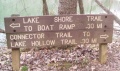
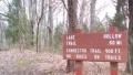
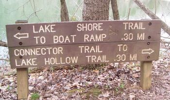
Located in Warriors Path State Park. Short 0.3 mile path along the shore of Ft. Patrick Henry Lake connecting Lakeshore Trail and Lake Hollow Trail, so that you can walk a loop around the park campground.
How to get there[edit]
Directions to main entrance found on Warriors Path State Park webpage. No direct trailhead. Reached by hiking either Lakeshore Trail and Lake Hollow Trail.
Route Description[edit]
Path proceeds around the east peninsula along the shoreline below the main park campground. There are no trail blazes, but the route is clear.
Typical Conditions[edit]
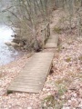
Well worn path with detours as the trees fall and shoreline crumbles into the lake. The park has installed RR ties as steps.
Fees, Permits, etc.[edit]
No fee required.
The path shown below in red is the Lake Hollow. The section in dark blue is this Connector Trail. And the piece in orange is the Lakeshore.
Loading map...
{"type":"TERRAIN","minzoom":false,"maxzoom":false,"types":["ROADMAP","SATELLITE","HYBRID","TERRAIN"],"mappingservice":"googlemaps3","width":"auto","height":"550px","centre":{"text":"","title":"","link":"","lat":36.4951999999999969759301166050136089324951171875,"lon":-82.480999999999994543031789362430572509765625,"icon":""},"title":"","label":"","icon":"","lines":[],"polygons":[],"circles":[],"rectangles":[],"copycoords":false,"static":false,"visitedicon":"","wmsoverlay":false,"zoom":15,"layers":[],"controls":["pan","zoom","type","scale","streetview","rotate"],"zoomstyle":"DEFAULT","typestyle":"DEFAULT","autoinfowindows":false,"resizable":false,"kmlrezoom":false,"poi":true,"cluster":false,"clustergridsize":60,"clustermaxzoom":20,"clusterzoomonclick":true,"clusteraveragecenter":true,"clusterminsize":2,"imageoverlays":[],"kml":[],"gkml":["https://tehcc.org/clubwiki/kml/WPSP_Connector_Trail.kml","https://tehcc.org/clubwiki/kml/WPSP_Lake_Hollow_Trail.kml","https://tehcc.org/clubwiki/kml/WPSP_Lakeshore_Trail.kml"],"searchmarkers":"","fullscreen":false,"scrollwheelzoom":false,"locations":[{"text":"\u003Cdiv class=\"mw-parser-output\"\u003E\u003Cp\u003EIntersection Lakeshore and Connector Trails\n\u003C/p\u003E\u003C/div\u003E","title":"Intersection Lakeshore and Connector Trails\n","link":"","lat":36.49741000000000212821760214865207672119140625,"lon":-82.4776399999999938472683425061404705047607421875,"icon":"/clubwiki/images/MarkerT.png"},{"text":"\u003Cdiv class=\"mw-parser-output\"\u003E\u003Cp\u003EIntersection Lake Hollow and Connector Trails\n\u003C/p\u003E\u003C/div\u003E","title":"Intersection Lake Hollow and Connector Trails\n","link":"","lat":36.4952899999999971214492688886821269989013671875,"lon":-82.476460000000002992237568832933902740478515625,"icon":"/clubwiki/images/MarkerT.png"},{"text":"\u003Cdiv class=\"mw-parser-output\"\u003E\u003Cp\u003EGirl Power Bench\n\u003C/p\u003E\u003C/div\u003E","title":"Girl Power Bench\n","link":"","lat":36.4966500000000024783730623312294483184814453125,"lon":-82.475650000000001682565198279917240142822265625,"icon":"/clubwiki/images/MarkerK.png"},{"text":"\u003Cdiv class=\"mw-parser-output\"\u003E\u003Cp\u003ETrail bridge\n\u003C/p\u003E\u003C/div\u003E","title":"Trail bridge\n","link":"","lat":36.497309999999998808561940677464008331298828125,"lon":-82.477339999999998099156073294579982757568359375,"icon":"/clubwiki/images/MarkerL.png"}]}
State Park Map and Trail Brochure
Park brochure incorrectly lists trail distance as 0.75 miles, but is 0.3 mile.
"Built by Girl Power" bench - Girls Inc
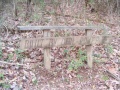
Pair of back-to-back trail bridges
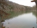
View from nice fishing spot
Sign at grey water disposal station