Darwin's Revenge
| Darwin's Revenge (log in to submit report) | |
|---|---|

| |
| Trail System | Warriors' Path State Park Mountain Bike Trails |
| Park | Warriors' Path State Park |
| Located | Kingsport, TennesseeLocation inherited from associated park |
| Trail Marking | Black Diamond |
| Trail UseThings allowed to do on or near the trail |
|
| FeaturesThings to see on or near the trail |
|
| Difficulty Rating | Medium |
| Hiking TimeTime from car and back. Includes any time hiking to access this trail. | 1 hr0.0625 Days <br />60 Min <br /> round trip |
| Distance: | 2.06 mi3.315 km <br /> trailStrict non-repeating trail length / 2.19 mi3.524 km <br /> round tripTypical or shortest length from the car, hike the trail, and return to car |
| Trail Type | Loop |
| Low / High Point | 1,265 ft421.667 Yards <br />385.572 Meters <br /> / 1,557 Ft519 Yards <br />474.574 Meters <br /> |
| Elev. Gain/LossSee link for details of calculation. Gain/Loss is direction dependent. | 289 Ft88.087 Meters <br /> / (233 Ft71.018 Meters <br />) – Clockwise |
| Trip ReportsFrom user "hiked it" submissions<br />Recent is within last 90 days | 8 logged hikes (0 recent) |
| NearbyWithin 5 mi<br />Click link to view list | 23 trails / 15.2 mi of trail |
| Parking | 36° 29' 31.67" N, 82° 28' 6.85" W Map |
| Trailhead | 36° 29' 27.06" N, 82° 28' 12.94" W Map |
|
| |
| Show In Google Maps | |
Download KML / Upload new version / KML File Page / Create Profile Chart / gpsvisualizer Map
Darwin's Revenge is the red line. Boneyard is dark green. Whitetail Loop with Rock City is dark blue. All three routes start from the parking lot kiosk.
Trail Overview[edit]
Located in Warriors Path State Park and part of the Mountain Bike Trail system, Darwin's Revenge is one of the three main loops to hike or bike. Good for stretching your legs, but don't expect seclusion or sounds of nature as this trail in particular stays close to I-81, but it does offer some good views of the river.
How to get there[edit]
From the main entrance of Warriors Path State Park:
- Go north on Fall Creek Road for 2.4 miles.
- Turn right (east) onto Old Mill Road for 0.8 miles.
- Turn right (south) onto Childress Ferry Road for just roughly 100 yards.
- Turn left (east) onto Buttermilk Road for 1.2 miles.
- Turn right (south) onto Freeman Road for 0.5 mile.
- Continue when road changes from asphalt to gravel.
Trailhead at gravel parking lot.
Route Description[edit]

Darwin's Revenge is typically done as a loop using a little bit of Lake Road and Boneyard Connector to either get started or to finish.
The trail has connections with Boneyard, Boneyard Connector, Wahoo, and Darwin's Connector
Typical Conditions[edit]
The mountain biking association SORBA Tri-Cities handles the trail maintenance, thus generally in good condition. While there are no blazes to guide you through the forest, the narrow single tracks are well established. Grab a trail map at the parking lot kiosk to help you decipher intersections; some which could use signs. Be aware for approaching bike riders who can come up quickly on your group. Step aside to let them safely pass.
Fees, Permits, etc.[edit]
No fee required. Dogs are allowed on or off leash. Do not drink any water without treatment!
Photos[edit]
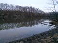
Lakefront view
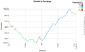
Elevation profile view