Pawpaw
| Pawpaw (log in to submit report) | |
|---|---|

| |
| Highlight | Half mile loop that can be added to Lake Road or connect with Whitetail |
| Trail System | Warriors' Path State Park Mountain Bike Trails |
| Park | Warriors' Path State Park |
| Located | Kingsport, TennesseeLocation inherited from associated park |
| Trail Marking | Blue |
| Trail UseThings allowed to do on or near the trail |
|
| FeaturesThings to see on or near the trail |
|
| Difficulty Rating | Medium |
| Hiking TimeTime from car and back. Includes any time hiking to access this trail. | 30 min0.5 Hours <br />0.0313 Days <br /> round trip |
| Distance: | 0.5608 mi0.903 km <br /> trailStrict non-repeating trail length / 2.0 mi3.219 km <br /> round tripTypical or shortest length from the car, hike the trail, and return to car |
| Trail Type | Segment |
| Low / High Point | 1,333 ft444.333 Yards <br />406.298 Meters <br /> / 1,434 Ft478 Yards <br />437.083 Meters <br /> |
| Elev. Gain/LossSee link for details of calculation. Gain/Loss is direction dependent. | 69 Ft21.031 Meters <br /> / (69 Ft21.031 Meters <br />) – Clockwise |
| Trip ReportsFrom user "hiked it" submissions<br />Recent is within last 90 days | 1 logged hikes (0 recent) |
| NearbyWithin 5 mi<br />Click link to view list | 24 trails / 19.0 mi of trail |
| Parking | 36° 29' 32.06" N, 82° 28' 6.24" W Map |
| Trailhead | 36° 29' 44.23" N, 82° 28' 13.01" W Map |
|
| |
| Show In Google Maps | |
Download KML / Upload new version / KML File Page / Create Profile Chart / gpsvisualizer Map
Darwin's Revenge is the red line. Boneyard is dark green. Whitetail Loop with Rock City is dark blue. All three routes start from the parking lot kiosk.
Trail Overview[edit]
Located in Warriors Path State Park.
How to get there[edit]
From main entrance of Warriors Path State Park:
- Go north on Fall Creek Road for 2.4 miles.
- Turn right (east) onto Old Mill Road for 0.8 miles.
- Turn right (south) onto Childress Ferry Road for just roughly 100 yards.
- Turn left (east) onto Buttermilk Road for 1.2 miles.
- Turn right (south) onto Freeman Road for 0.5 mile.
- Continue when road changes from asphalt to gravel.
Trailhead at gravel parking lot.
Route Description[edit]

Simple loop that ends where it began... if you can figure out the trail routing! Trail connects to Lake Road in the powerline cut by using Pawpaw Connector. At the trailhead, the Pawpaw trail goes both left and right forming the loop. Go clockwise by starting to the left. At about 0.3mi in the trail will intersect with Whitetail Loop. The "proper" way to go is to U-turn and follow Whitetail Loop (not go straight back into the powerline cut), and down the hill slightly where the trail splits again. Whitetail Loop continues straight across the powerline cut, while Pawpaw goes back into the woods to complete the inner trail and finally terminate back where it began.
The round-trip distance is based on taking Lake Road to the Pawpaw Connector, then completing the loop and returning back on Lake Road.
Typical Conditions[edit]
The mountain biking association SORBA Tri-Cities handles the trail maintenance, thus generally in good condition. While there are no blazes to guide you through the forest, the narrow single tracks are well established. Grab a trail map at the parking lot kiosk to help you decipher intersections; some which could use signs. Be aware for approaching bike riders who can come up quickly on your group. Step aside to let them safely pass.
Fees, Permits, etc.[edit]
No fee required. Dogs are allowed on or off leash. Do not drink any water without treatment!
Photos[edit]
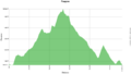
Trail Profile
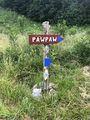
Pawpaw trail sign off Lake Road Trail