Search results
Jump to navigation
Jump to search
Page title matches
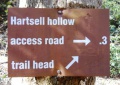
File:White Rock Trail - Hartsell Hollow trail sign.JPG |File name=White Rock Trail - Hartsell Hollow trail sign.JPG |Trail=White Rock Trail(448 × 317 (109 KB)) - 22:52, 23 December 2018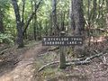
File:PCSP Point Lookout Trail - spur trail sign.JPG |File name=PCSP Point Lookout Trail - spur trail sign.JPG |Trail=Point Lookout Trail(4,032 × 3,024 (7.89 MB)) - 21:04, 11 September 2020
File:PCSP Norris Blackburn Trail - hiking trail marker.JPG |File name=PCSP Norris Blackburn Trail - hiking trail marker.JPG |Trail=Norris Blackburn Trail(3,024 × 4,032 (5.37 MB)) - 21:24, 11 September 2020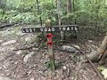
File:PCSP Lost Road Trail - trail junction sign.JPG |File name=PCSP Lost Road Trail - trail junction sign.JPG |Trail=Lost Road Trail(4,032 × 3,024 (5.83 MB)) - 07:50, 14 September 2020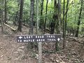
File:PCSP Lost Road Trail - another trail junction sign.JPG |File name=PCSP Lost Road Trail - another trail junction sign.JPG |Trail=Lost Road Trail(4,032 × 3,024 (5.76 MB)) - 08:02, 14 September 2020
File:Phipps Bend Trail - near trail end.jpg |File name=Phipps Bend Trail - near trail end.jpg |Trail=Phipps Bend Trail(600 × 450 (80 KB)) - 12:39, 28 July 2020- ...il' template. It is expected to be typically used by the [[Form:Trail|Form Trail]]. This template creates the 'sidebar' with info about each trail like the state, nearest city, coordinates of the tail head. If not used, en9 KB (1,166 words) - 19:07, 15 April 2023
- ...rsion to the current Trail Template (or Park) format. This would place the trail in the category [[:Category:Trails|Trails]]. {{#ask: [[Category:Trail]]52 members (0 subcategories, 0 files) - 00:14, 30 December 2019
- 119 bytes (22 words) - 23:47, 9 October 2015
- This is the "Trail" form. {{#forminput:form=Trail}}8 KB (1,248 words) - 22:29, 11 September 2020
- ...OLETE" are not to be used and should be deleted in the usage if updating a trail page. They are left here for backward compatibility and will be removed onc {{Infobox Trail6 KB (844 words) - 11:01, 20 November 2018
- {{Trail |Banner Image=File:Lakeside Trail - Bays Mountain Dam.jpg4 KB (663 words) - 17:12, 19 March 2023
- Below are the images seen on the trail infoboxes, what they mean, and how to use them if you edit trails. !Name in trail editing lists2 KB (295 words) - 15:22, 6 October 2019
- -->{{Infobox Trail | Trail Use = {{Hike}} {{Skiing}}4 KB (508 words) - 11:21, 21 November 2015
- {{Trail |Trail Highlight=Access to the Sand Cave and White Rocks (the colloquially known n7 KB (1,173 words) - 23:19, 27 November 2019
- <noinclude>This returns a map of the trails associated with the trail page it is called on. {{Trail Map|Main Trail={{PAGENAME}}|Other Trails= |Zoom Cancel=[any entry will trigger cancel]}}8 KB (992 words) - 13:30, 23 March 2023
- {{Trail |Trail Marking=Signs2 KB (265 words) - 23:30, 15 December 2019
- {{Trail |Trail Highlight=Connects Lakeside Trail with Lake Road2 KB (281 words) - 15:51, 15 December 2019
- {{Trail |Banner Image=File:BMP Azalea Trail.JPG3 KB (372 words) - 20:34, 12 April 2023
- {{Trail |Trail Marking=Signs2 KB (262 words) - 17:03, 15 December 2019
- {{Trail |Trail Marking=Signs2 KB (295 words) - 20:07, 15 December 2019
- {{Trail |Banner Image=File:BMP Orchid Trail sign.JPG2 KB (294 words) - 19:17, 15 December 2019
- {{Trail |Banner Image=File:BMP Cliffside Trail view from obs tower towards firetower.JPG4 KB (520 words) - 22:48, 14 December 2019
- ...ieces will provide background information to allow more folks to enjoy the trail.6 members (0 subcategories, 0 files) - 05:48, 16 April 2012
- ...on of a trail (including park page defined stubs). Its expected use is for trail tables and map balloons.193 bytes (34 words) - 15:36, 24 November 2019
- {{Trail |Banner Image=File:BMP Chinquapin Trail.JPG3 KB (448 words) - 20:49, 14 December 2019
- #REDIRECT [[Barred Owl Trail]]30 bytes (4 words) - 20:34, 12 April 2023
- This trail name is used by more than one park. * [[Lake Trail (Big Ridge State Park)]]181 bytes (29 words) - 23:36, 30 November 2019
- {{Trail |Trail Highlight=5,560' summit with view of northern highlands6 KB (930 words) - 22:36, 2 December 2019
- {{Trail |Trail Marking=Signs3 KB (468 words) - 14:50, 14 December 2019
- -->{{Infobox Trail | Trail Number =5 KB (776 words) - 12:12, 7 January 2023
- -->{{Infobox Trail | Trail Use = {{Hike}} {{Biking}} {{Dogs}}4 KB (565 words) - 09:42, 31 October 2015
- {{Trail |Trail Highlight=Nice views of the viaduct and Grandfather Mountain3 KB (469 words) - 08:20, 7 December 2019
- -->{{Infobox Trail | Trail Use = {{Hike}} {{Dogs}}5 KB (666 words) - 12:12, 7 January 2023
- {{Trail |Trail Marking=White3 KB (493 words) - 14:01, 19 September 2021
- |Trail Condition=Problems147 bytes (21 words) - 18:04, 2 May 2024
- ...of the hike is in the shade. It is a great opportunity to get out on the trail even if you or your family don’t have a lot of experience hiking. <br>'''F/B: Bays Mountain Park - Lakeside Trail, Saturday, May 24''', 2:00 pm – 3:30 pm2 KB (267 words) - 15:32, 30 May 2019
- ...d back down towards the parking lot. We picked up the 2.1-mile Cabin Creek Trail to see the waterfall and ate lunch along the rocks in front of it.2 KB (295 words) - 13:38, 15 June 2014
- -->{{Infobox Trail | Trail Use = {{Hike}} {{Biking}} {{Dogs}}3 KB (501 words) - 15:53, 20 May 2019
- {{Trail |Trail Highlight=A Rails-to-Trail between Bristol and Mendota, VA5 KB (792 words) - 20:01, 16 June 2023
- ...s. This is different than a Park. Most distinct example is the Appalachian Trail System which is made up of trails in many parks, regions, states, etc.254 bytes (46 words) - 14:01, 6 December 2018
- ...the type [[Has type::Page|Page]]. It was created to be the used to log the trail hiked for a hike event.115 bytes (25 words) - 20:35, 29 September 2015
- 37 bytes (4 words) - 21:57, 10 September 2015
- These pages are trail stubs typically expected to be created on Park pages using the form. {{#ask: [[Category:Trail Stubs]]0 members (0 subcategories, 0 files) - 09:09, 26 November 2019
- ..., would be 2.5 mi, where as the field [[Property:Trail distance round trip|Trail distance round trip]] would be 3.0 mi.589 bytes (91 words) - 21:15, 18 September 2015
- ...d to hold the choice of Loop / Segment / In-and-Out to signify roughly the trail type. ...'' hikes are those hikes where a significant portion, at least half of the trail, can be completed without repeating large sections in the reverse. Addition841 bytes (146 words) - 10:08, 4 October 2015
- ...is a property of type [[Has type::Text|Text]]. It is used to describe the trail blaze, unless otherwise unique, simply the color name should suffice.154 bytes (27 words) - 12:25, 26 April 2018
- ...he 'Trail Search' template. It should be called via the [[Special:RunQuery/Trail Search]] form. {{#if: {{{trail uses|}}}|[[Allowed activities::{{{trail uses|}}}]]}}873 bytes (90 words) - 14:25, 24 June 2023
- This is the "Trail Search" form. {{#forminput:form=Trail Search}}844 bytes (114 words) - 14:27, 24 June 2023
- ...ype [[Has type::Text|Text]]. It is used to list the updates needed for the trail page. Intent is to make it easier to find trails that need various updates. ...description;Photos;Winter photos;Stub;Remove trail in name;Update infobox;Trail pins;Update mileage|+sep=;918 bytes (146 words) - 18:47, 16 October 2015


Page text matches
- ...OLETE" are not to be used and should be deleted in the usage if updating a trail page. They are left here for backward compatibility and will be removed onc {{Infobox Trail6 KB (844 words) - 11:01, 20 November 2018
- |Trail Map Link=https://www.nps.gov/cuga/planyourvisit/upload/CUGAmap1-3.pdf {{Park trail map}}4 KB (565 words) - 11:29, 16 June 2023
- #REDIRECT [[Ewing Trail]]25 bytes (3 words) - 23:17, 27 November 2019
- #REDIRECT [[Talk:Ewing Trail]]30 bytes (4 words) - 23:17, 27 November 2019
- [[Template:Trail]] [[Template:Infobox Trail]]1 KB (155 words) - 21:38, 20 February 2011
- '''Welcome to Tennessee Eastman Hiking and Canoeing Club's Trail WIKI''' Our online repository for everything trail related within a reasonable distance from our club's center in Kingsport TN9 KB (1,394 words) - 18:18, 14 July 2023
- {{#ask: [[Category:Waterfalls]][[Trail State::Virginia]]139 bytes (14 words) - 19:43, 31 August 2015
- ...Text|Text]]. It is used to hold the choice of Easy / Medium / Hard for the trail hike difficulty135 bytes (26 words) - 20:57, 17 September 2015
- ...ip distance one would take to get to this trail, hike the entirety of this trail and return to the starting area.486 bytes (75 words) - 10:32, 23 December 2019
- ...2.47760~[[WPSP Sinking Waters|Sinking Waters]]~Here is the location of the trail head~MarkerA.png~ ~This is where Putin Works ...reek_Loop_Trail|Fall Creek Loop]]<br>[[Image:To D Backbone Trail.jpg|150px|Trail head sign]]10 KB (1,633 words) - 12:12, 7 January 2023
- {{Trail |Banner Image=File:BMP Firetower Trail tower.jpg4 KB (529 words) - 22:07, 10 December 2019
- !Trail distance from Damascus1 KB (201 words) - 18:24, 20 February 2023
- ...distance, thus reported for annual data book update. This page, like the trail itself, is a work in progress to figure out how to best use the available t <br>- Backbone Rock Trail (blue blaze)7 KB (1,010 words) - 12:12, 7 January 2023
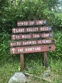
File:WPSP Main Split signs.JPG |Trail=Boneyard, Lake Road (Warriors Path State Park), Whitetail Loop, Zipline |Caption=Signs at main trail split(3,024 × 4,032 (4.76 MB)) - 11:45, 24 June 2023- Arguably the most unique shelter on the entire Appalachian Trail with a great view looking down into Roaring Creek Valley. A classic wooden ...d Carvers Gap. The shelter is 0.3 miles east of AT. on a blue-blazed side trail. In the Pisgah National Forest, Toecane Ranger District. Located on the [[C4 KB (605 words) - 07:28, 20 November 2023
- Water is found 100 yards from the shelter on a blue blaze trail. <!-- Place any pictures from this trail below. Add a picture by typing Image:imagename.extension -->2 KB (282 words) - 12:04, 21 December 2018
- ...il' template. It is expected to be typically used by the [[Form:Trail|Form Trail]]. This template creates the 'sidebar' with info about each trail like the state, nearest city, coordinates of the tail head. If not used, en9 KB (1,166 words) - 19:07, 15 April 2023
- <!-- Add additional columns for distance from Bristol/trail distance/AT or branch --> !Trail5 KB (506 words) - 17:26, 10 June 2023
- {{Trail |Trail Marking=Blue7 KB (1,046 words) - 15:35, 10 January 2023
- {{Trail |Trail Highlight=Your likely trail if you want to "go to The Channels"6 KB (906 words) - 10:47, 8 January 2023
File:The Great Channels1.jpg |Trail=The Channels Natural Area Preserve(768 × 1,024 (139 KB)) - 22:39, 15 November 2018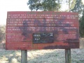
File:Sinking Waters information sign.jpg |Trail=Sinking Waters(768 × 576 (123 KB)) - 15:07, 20 November 2018- |Trail Map Link=https://baysmountainpa.wpengine.com/wp-content/uploads/Trail-Map-Brochure-Front-5-7-18.pdf 36.50803,-82.61255~Lakeside Trail~ ~MarkerG.png9 KB (1,288 words) - 15:10, 13 June 2023
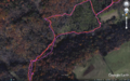
File:Comparison of etrex and forerunner logging.PNG ...nta/pink. The eTrex track was more consistent upon trail returns and known trail locations/shape.(1,566 × 974 (3.49 MB)) - 00:39, 2 January 2020- {{Trail |Banner Image=File:Lakeside Trail - Bays Mountain Dam.jpg4 KB (663 words) - 17:12, 19 March 2023
- == Getting started adding a trail page == Steps to creating a new trail (or filling out a referenced one that has no page)10 KB (1,857 words) - 17:31, 8 March 2020
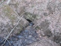
File:Sinking Waters sinkhole.jpg |Trail=Sinking Waters(2,048 × 1,536 (910 KB)) - 12:24, 19 November 2018- |Trail Map Link=https://tnstateparks.com/assets/pdf/additional-content/park-maps/4 |Park Trail Count=9 KB (1,271 words) - 11:59, 19 September 2021
- {{Trail |Trail Highlight=Three connected loops and a stream that disappears into a sinkhol9 KB (1,357 words) - 17:53, 14 December 2019
- |Trail Condition=Clear |Trail Comment=Good. Some decking felt loose and handrail is knocked off in wetlan520 bytes (81 words) - 10:42, 8 December 2018
- {{Trail |Trail Number=FS #1895 KB (728 words) - 20:56, 21 May 2023
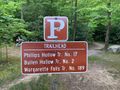
File:IMG 3495.jpg |Trail=Margarette Falls(640 × 480 (161 KB)) - 21:05, 21 May 2023
File:Margarette Falls-profile.png |Trail=Margarette Falls(760 × 460 (22 KB)) - 22:32, 4 December 2018
File:Margarette falls 01.jpg |Trail=Margarette Falls(1,200 × 900 (620 KB)) - 22:08, 4 December 2018- ...slippery, but we made it, took in the sights, and quickly headed back down trail to the warmer weather. Overall it was barely frozen and compared to picture ...in the water. This popular falls is considerably easier to get to now. The trail work is top notch...3 KB (533 words) - 00:54, 14 May 2012

File:Dnr atv.png Trail logo to signify ATV use |Caption=Signifies that ATVs are allowed on at least some of the trail<br>'''Note''': Check with proper authorities for which specific trails allo(80 × 80 (2 KB)) - 18:29, 21 November 2018
File:Dnr bike.png |Caption=Signifies that bicycles are allowed on at least some of the trail<br>'''Note''': Check with proper authorities for which specific trails allo(80 × 80 (2 KB)) - 18:30, 21 November 2018
File:Dnr fishing.png ...ignifies that fishing might be allowed on at least some streams nearby the trail<br>'''Note:''' Check with proper authorities for locations and license requ(80 × 80 (1 KB)) - 18:21, 21 November 2018
File:Dnr hiking.png |Caption=Signifies that hiking is allowed on the trail(80 × 80 (2 KB)) - 17:44, 21 November 2018
File:Dnr skiing.png |Caption=Signifies that skiing is allowed on the trail and is common in the winter(80 × 80 (1 KB)) - 18:26, 21 November 2018
File:Dnr waterfall.png |Caption=There are waterfalls within the park or near the trail(80 × 80 (2 KB)) - 09:17, 23 November 2018- ...g'. It is normally used in infoboxes to display allowed use on or near the trail or at the park.474 bytes (72 words) - 10:57, 20 November 2018
- ...s'. It is normally used in infoboxes to display allowed use on or near the trail or at the park.460 bytes (72 words) - 10:51, 20 November 2018
- ...V'. It is normally used in infoboxes to display allowed use on or near the trail or at the park.457 bytes (72 words) - 10:45, 20 November 2018
- ...g'. It is normally used in infoboxes to display allowed use on or near the trail.456 bytes (68 words) - 10:50, 20 November 2018
- ...g'. It is normally used in infoboxes to display allowed use on or near the trail or at the park.475 bytes (72 words) - 10:51, 20 November 2018
- ...g'. It is normally used in infoboxes to display allowed use on or near the trail or at the park.481 bytes (72 words) - 10:56, 20 November 2018
- ...s'. It is normally used in infoboxes to display allowed use on or near the trail or at the park.483 bytes (73 words) - 10:57, 20 November 2018
- ...r'. It is normally used in infoboxes to display allowed use on or near the trail or at the park.481 bytes (72 words) - 11:35, 20 November 2018
- ...g'. It is normally used in infoboxes to display allowed use on or near the trail or at the park.474 bytes (72 words) - 11:35, 20 November 2018


