Loading map...
{"format":"googlemaps3","type":"TERRAIN","minzoom":false,"maxzoom":false,"types":["SATELLITE","HYBRID","TERRAIN"],"limit":50,"offset":0,"link":"none","sort":[""],"order":[],"headers":"show","mainlabel":"","intro":"","outro":"","searchlabel":"... further results","default":"","import-annotation":false,"width":"auto","height":"600px","centre":false,"title":"","label":"","icon":"","lines":[],"polygons":[],"circles":[],"rectangles":[],"copycoords":false,"static":false,"visitedicon":"","wmsoverlay":false,"zoom":false,"layers":[],"controls":["pan","zoom","type","scale","streetview","rotate"],"zoomstyle":"DEFAULT","typestyle":"DEFAULT","autoinfowindows":false,"resizable":false,"kmlrezoom":true,"poi":true,"cluster":false,"clustergridsize":60,"clustermaxzoom":20,"clusterzoomonclick":true,"clusteraveragecenter":true,"clusterminsize":2,"imageoverlays":[],"kml":[],"gkml":["https://tehcc.org/clubwiki/images/Bays_Mountain_Road.kml","https://tehcc.org/clubwiki/images/Cliffside_Trail.kml"],"searchmarkers":"","fullscreen":false,"scrollwheelzoom":false,"showtitle":false,"hidenamespace":true,"template":"Map Balloon Template","userparam":"","activeicon":"","pagelabel":false,"ajaxcoordproperty":"","ajaxquery":"","locations":[{"text":"\u003Cp\u003E\u003Cb\u003E\u003Ca href=\"/wiki/Bays_Mountain_Road\" title=\"Bays Mountain Road\"\u003EBays Mountain Road\u003C/a\u003E\u003C/b\u003E\u003Cbr /\u003E\u003C/p\u003E\u003Chr /\u003E\u003Cp\u003E2.08\u0026#160;Mi (3.35\u0026#160;km)\u003Cbr /\u003EDifficulty: Medium\u003Cbr /\u003EMarking: Signs\u003C/p\u003E","title":"Bays Mountain Road","link":"","lat":36.50854000000000354475560015998780727386474609375,"lon":-82.6111700000000013233147910796105861663818359375,"icon":"/clubwiki/images/MarkerT.png"},{"text":"\u003Cp\u003E\u003Cb\u003EIntersection\u003C/b\u003E\u003Cbr /\u003E\u003C/p\u003E\u003Chr /\u003E\u003Cp\u003E\u003Ca href=\"/wiki/Azalea\" title=\"Azalea\"\u003EAzalea\u003C/a\u003E\u003C/p\u003E","title":"Bays Mountain Road","link":"","lat":36.52615999999999729652699897997081279754638671875,"lon":-82.5877799999999950841811369173228740692138671875,"icon":"/clubwiki/images/MarkerG.png"},{"text":"\u003Cp\u003E\u003Cb\u003EOverlook platform\u003C/b\u003E\u003Cbr /\u003E\u003C/p\u003E\u003Chr /\u003E\u003Cp\u003EOverlook platform\u003C/p\u003E","title":"Bays Mountain Road","link":"","lat":36.52300000000000324007487506605684757232666015625,"lon":-82.5900100000000065847416408360004425048828125,"icon":"/clubwiki/images/MarkerE.png"},{"text":"\u003Cp\u003E\u003Cb\u003ELocked gate on Bays Mountain Road\u003C/b\u003E\u003Cbr /\u003E\u003C/p\u003E\u003Chr /\u003E\u003Cp\u003E\u003Ca href=\"/wiki/File:BMP_Bays_Mountain_Road_gate.JPG\" class=\"image\"\u003E\u003Cimg alt=\"BMP Bays Mountain Road gate.JPG\" src=\"/clubwiki/images/thumb/BMP_Bays_Mountain_Road_gate.JPG/150px-BMP_Bays_Mountain_Road_gate.JPG\" decoding=\"async\" width=\"150\" height=\"113\" srcset=\"/clubwiki/images/thumb/BMP_Bays_Mountain_Road_gate.JPG/225px-BMP_Bays_Mountain_Road_gate.JPG 1.5x, /clubwiki/images/thumb/BMP_Bays_Mountain_Road_gate.JPG/300px-BMP_Bays_Mountain_Road_gate.JPG 2x\" data-file-width=\"1024\" data-file-height=\"768\" /\u003E\u003C/a\u003E\u003C/p\u003E","title":"Bays Mountain Road","link":"","lat":36.50706000000000273075784207321703433990478515625,"lon":-82.609790000000003828972694464027881622314453125,"icon":"/clubwiki/images/MarkerG.png"},{"text":"\u003Cp\u003E\u003Cb\u003EAntennas, elevation 2250'\u003C/b\u003E\u003Cbr /\u003E\u003C/p\u003E\u003Chr /\u003E\u003Cp\u003E\u003Ca href=\"/wiki/File:BMP_Antennas2.JPG\" class=\"image\"\u003E\u003Cimg alt=\"BMP Antennas2.JPG\" src=\"/clubwiki/images/thumb/BMP_Antennas2.JPG/100px-BMP_Antennas2.JPG\" decoding=\"async\" width=\"100\" height=\"320\" srcset=\"/clubwiki/images/BMP_Antennas2.JPG 1.5x\" data-file-width=\"140\" data-file-height=\"448\" /\u003E\u003C/a\u003E\u003C/p\u003E","title":"Bays Mountain Road","link":"","lat":36.5272599999999982856024871580302715301513671875,"lon":-82.5861000000000018417267710901796817779541015625,"icon":"/clubwiki/images/MarkerE.png"},{"text":"\u003Cp\u003E\u003Cb\u003ELookout tower, elevation 2172'\u003C/b\u003E\u003Cbr /\u003E\u003C/p\u003E\u003Chr /\u003E\u003Cp\u003E\u003Ca href=\"/wiki/File:BMP_Cliffside_Trail_lookout.JPG\" class=\"image\"\u003E\u003Cimg alt=\"BMP Cliffside Trail lookout.JPG\" src=\"/clubwiki/images/thumb/BMP_Cliffside_Trail_lookout.JPG/150px-BMP_Cliffside_Trail_lookout.JPG\" decoding=\"async\" width=\"150\" height=\"200\" srcset=\"/clubwiki/images/thumb/BMP_Cliffside_Trail_lookout.JPG/225px-BMP_Cliffside_Trail_lookout.JPG 1.5x, /clubwiki/images/thumb/BMP_Cliffside_Trail_lookout.JPG/300px-BMP_Cliffside_Trail_lookout.JPG 2x\" data-file-width=\"768\" data-file-height=\"1024\" /\u003E\u003C/a\u003E\u003C/p\u003E","title":"Bays Mountain Road","link":"","lat":36.50842999999999705096342950128018856048583984375,"lon":-82.60448999999999841747921891510486602783203125,"icon":"/clubwiki/images/MarkerE.png"},{"text":"\u003Cp\u003E\u003Cb\u003E\u003Ca class=\"mw-selflink selflink\"\u003ECliffside Trail\u003C/a\u003E\u003C/b\u003E\u003Cbr /\u003E\u003C/p\u003E\u003Chr /\u003E\u003Cp\u003E0.76\u0026#160;Mi (1.22\u0026#160;km)\u003Cbr /\u003EDifficulty: Medium\u003Cbr /\u003EMarking: Signs\u003C/p\u003E","title":"Cliffside Trail","link":"","lat":36.50811999999999812871465110220015048980712890625,"lon":-82.610849999999999226929503493010997772216796875,"icon":"/clubwiki/images/MarkerT.png"},{"text":"\u003Cp\u003E\u003Cb\u003EView from higher overlook along trail\u003C/b\u003E\u003Cbr /\u003E\u003C/p\u003E\u003Chr /\u003E\u003Cp\u003E\u003Ca href=\"/wiki/File:BMP_Cliffside_Trail_higher_overlook.JPG\" class=\"image\"\u003E\u003Cimg alt=\"BMP Cliffside Trail higher overlook.JPG\" src=\"/clubwiki/images/thumb/BMP_Cliffside_Trail_higher_overlook.JPG/150px-BMP_Cliffside_Trail_higher_overlook.JPG\" decoding=\"async\" width=\"150\" height=\"90\" srcset=\"/clubwiki/images/thumb/BMP_Cliffside_Trail_higher_overlook.JPG/225px-BMP_Cliffside_Trail_higher_overlook.JPG 1.5x, /clubwiki/images/thumb/BMP_Cliffside_Trail_higher_overlook.JPG/300px-BMP_Cliffside_Trail_higher_overlook.JPG 2x\" data-file-width=\"448\" data-file-height=\"270\" /\u003E\u003C/a\u003E\u003C/p\u003E","title":"Cliffside Trail","link":"","lat":36.50672999999999746023604529909789562225341796875,"lon":-82.60984999999999445208231918513774871826171875,"icon":"/clubwiki/images/MarkerE.png"},{"text":"\u003Cp\u003E\u003Cb\u003ETrailhead near observatory at \"Sun\"\u003C/b\u003E\u003Cbr /\u003E\u003C/p\u003E\u003Chr /\u003E\u003Cp\u003E\u003Ca href=\"/wiki/File:BMP_Cliffside_Trail_sun.jpg\" class=\"image\"\u003E\u003Cimg alt=\"BMP Cliffside Trail sun.jpg\" src=\"/clubwiki/images/thumb/BMP_Cliffside_Trail_sun.jpg/150px-BMP_Cliffside_Trail_sun.jpg\" decoding=\"async\" width=\"150\" height=\"200\" srcset=\"/clubwiki/images/thumb/BMP_Cliffside_Trail_sun.jpg/225px-BMP_Cliffside_Trail_sun.jpg 1.5x, /clubwiki/images/thumb/BMP_Cliffside_Trail_sun.jpg/300px-BMP_Cliffside_Trail_sun.jpg 2x\" data-file-width=\"600\" data-file-height=\"800\" /\u003E\u003C/a\u003E\u003C/p\u003E","title":"Cliffside Trail","link":"","lat":36.50815999999999661440597265027463436126708984375,"lon":-82.610870000000005575202521868050098419189453125,"icon":"/clubwiki/images/MarkerT.png"},{"text":"\u003Cp\u003E\u003Cb\u003ETrailhead at Bays Mountain Road\u003C/b\u003E\u003Cbr /\u003E\u003C/p\u003E\u003Chr /\u003E\u003Cp\u003ETrailhead at Bays Mountain Road\u003C/p\u003E","title":"Cliffside Trail","link":"","lat":36.5085600000000027876012609340250492095947265625,"lon":-82.6045299999999969031705404631793498992919921875,"icon":"/clubwiki/images/MarkerT.png"},{"text":"\u003Cp\u003E\u003Cb\u003ETrail splits for old steps and alternative route\u003C/b\u003E\u003Cbr /\u003E\u003C/p\u003E\u003Chr /\u003E\u003Cp\u003ETrail splits for old steps and alternative route\u003C/p\u003E","title":"Cliffside Trail","link":"","lat":36.50657000000000351747075910679996013641357421875,"lon":-82.608980000000002519300323911011219024658203125,"icon":"/clubwiki/images/MarkerG.png"},{"text":"\u003Cp\u003E\u003Cb\u003EObservation tower\u003C/b\u003E\u003Cbr /\u003E\u003C/p\u003E\u003Chr /\u003E\u003Cp\u003E\u003Ca href=\"/wiki/File:BMP_Cliffside_Trail_lookout.JPG\" class=\"image\"\u003E\u003Cimg alt=\"BMP Cliffside Trail lookout.JPG\" src=\"/clubwiki/images/thumb/BMP_Cliffside_Trail_lookout.JPG/150px-BMP_Cliffside_Trail_lookout.JPG\" decoding=\"async\" width=\"150\" height=\"200\" srcset=\"/clubwiki/images/thumb/BMP_Cliffside_Trail_lookout.JPG/225px-BMP_Cliffside_Trail_lookout.JPG 1.5x, /clubwiki/images/thumb/BMP_Cliffside_Trail_lookout.JPG/300px-BMP_Cliffside_Trail_lookout.JPG 2x\" data-file-width=\"768\" data-file-height=\"1024\" /\u003E\u003C/a\u003E\u003C/p\u003E","title":"Cliffside Trail","link":"","lat":36.50845000000000339923644787631928920745849609375,"lon":-82.6044499999999999317878973670303821563720703125,"icon":"/clubwiki/images/MarkerE.png"},{"text":"\u003Cp\u003E\u003Cb\u003EView from lower overlook by observatory\u003C/b\u003E\u003Cbr /\u003E\u003C/p\u003E\u003Chr /\u003E\u003Cp\u003E\u003Ca href=\"/wiki/File:BMP_Cliffside_Trail_lower_overlook.JPG\" class=\"image\"\u003E\u003Cimg alt=\"BMP Cliffside Trail lower overlook.JPG\" src=\"/clubwiki/images/thumb/BMP_Cliffside_Trail_lower_overlook.JPG/150px-BMP_Cliffside_Trail_lower_overlook.JPG\" decoding=\"async\" width=\"150\" height=\"113\" srcset=\"/clubwiki/images/thumb/BMP_Cliffside_Trail_lower_overlook.JPG/225px-BMP_Cliffside_Trail_lower_overlook.JPG 1.5x, /clubwiki/images/thumb/BMP_Cliffside_Trail_lower_overlook.JPG/300px-BMP_Cliffside_Trail_lower_overlook.JPG 2x\" data-file-width=\"448\" data-file-height=\"336\" /\u003E\u003C/a\u003E\u003C/p\u003E","title":"Cliffside Trail","link":"","lat":36.5078800000000001091393642127513885498046875,"lon":-82.6107300000000037698555388487875461578369140625,"icon":"/clubwiki/images/MarkerE.png"}]}
From the main parking lot, head over to the observatory. The unmarked trail heads uphill from here. Alternatively, head up Bays Mountain Road to observation tower and take the trail back down.
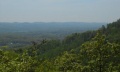
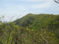
Short steep hike along the ridgeline with couple of lookout points and up to the observation tower.
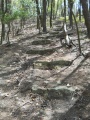
The older trail route is very worn and washed out on steep ascent with stone steps built long ago. Pine needle covered path once up on ridge line. Alternate route is newer side hill trail in excellent condition.
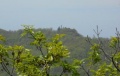
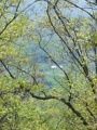
Selective removal of some trees around the lookout tower would greatly improve viewing year around.