Shelter:Abingdon Gap

| ||
| Shelter | Abingdon Gap | |
| Capacity | 5 People | |
| Privy | No | |
| Trail Head Distance N | 10.0 Miles | |
| Trail Head Distance S | 4.8 Miles | |
| Elevation | 3,773 Feet | |
| Latitude | {{#lat_deg2dms: 36.581095}} | |
| Longitude | {{#long_deg2dms: -81.90205}} | |
| Nearest Medical | Abingdon, VA | |
|
|
||
| Show Large Map | ||
Description[edit]
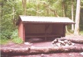
Basic three-sided concrete block/metal roof shelter with wooden sleeping platform and picnic table out front.
Location[edit]
The shelter is directly on AT on Holston Mountain between Damascus and US421 in Maple Springs Gap. Just over ten miles south of Damascus.
Water[edit]
A spring is located 275 yards down a hollow south of the shelter. Follow a fairly steep blue-blazed trail. Has two pipes. Flow depends on rainfall during the prior week. During summer, the spring may dry up, thus plan on traveling further down the hollow or packing in water.
Maintenance History[edit]
- Currently being checked by “Just Jim”.
- Jun 2016: Shelter painted by 3rd Saturday crew, then a graffiti board and sign was installed
- Apr 2007: Complete replacement the sleeping platform (thanks to grant from L.L. Bean). Also repaired water source by installing new pipe and cleaning out the pools.
- May 2003: Roof leak fixed.
- Nov 1992: New metal roof installed (thanks to Forest Service funding). Painted shelter inside and out. Carried donated picnic table to shelter.
- 1989: Roof repaired.
- 1959: Built by US Forest Service.
Misc. Information[edit]
Flint arrowheads were found just north of the shelter in the open clearing, thus demonstrating this spot has been great for travelers over many centuries.
Photo Gallery[edit]
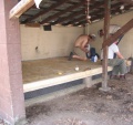
New Sleeping Platform

Water Source (April 2007)


| Shelter name | Section | Trail distance from Damascus |
|---|---|---|
| Abingdon Gap Shelter | US421 to Damascus | 10.2 |
| McQueens Knob Shelter (emergency shelter) | US421 to Damascus | 11.7 |
| Double Springs Shelter | TN91 to US421 | 18.5 |
| Iron Mountain Shelter | Wilbur Dam Rd to TN91 | 26.2 |
| Vandeventer Shelter | Wilbur Dam Rd to TN91 | 33.0 |
| Laurel Fork Shelter | Dennis Cove Rd to Wilbur Dam Rd | 49.5 |
| Moreland Gap Shelter | US19E to Dennis Cove Rd | 57.0 |
| Mountaineer Falls Shelter | US19E to Dennis Cove Rd | 66.6 |
| Stan Murray Shelter | Carver's Gap to US19E | 86.5 |
| Roan High Knob Shelter | Iron Mountain Gap to Carver's Gap | 91.7 |
| Clyde Smith Shelter | Iron Mountain Gap to Carver's Gap | 100.2 |
| Cherry Gap Shelter | Indian Grave Gap to Iron Mountain Gap | 109.3 |
| Curley Maple Gap Shelter | Nolichucky River to Indian Grave Gap | 122.2 |
| No Business Knob Shelter | Spivey Gap to Nolichucky River | 132.7 |
Per the 2021 AT Data Book.