US421 to Damascus
| US421 to Damascus (log in to submit report) | |
|---|---|

| |
| Trail System | Appalachian Trail |
| Land Owner | Cherokee National Forest |
| Located | Erwin, Tennessee |
| Trail Marking | White |
| Trail UseThings allowed to do on or near the trail |
|
| FeaturesThings to see on or near the trail |
|
| Difficulty Rating | Medium |
| Hiking TimeTime from car and back. Includes any time hiking to access this trail. | 5 hrs0.313 Days <br />300 Min <br /> round trip |
| Distance: | 11.3 mi18.186 km <br /> trailStrict non-repeating trail length / 22.4 mi36.049 km <br /> round tripTypical or shortest length from the car, hike the trail, and return to car |
| Trail Type | In-and-Out |
| Low / High Point | 3,204 ft1,068 Yards <br />976.579 Meters <br /> / 3,913 ft1,304.333 Yards <br />1,192.682 Meters <br /> |
| Elev. Gain/LossSee link for details of calculation. Gain/Loss is direction dependent. | 1,682 ft512.674 Meters <br /> / (1,854 ft565.099 Meters <br />) – South-to-North |
| Trip ReportsFrom user "hiked it" submissions<br />Recent is within last 90 days | 1 logged hikes (0 recent) |
| NearbyWithin 5 mi<br />Click link to view list | 2 trails / 24.3 mi of trail |
| Parking | 36° 32' 19.25" N, 81° 56' 56.65" W Map |
| Trailhead | 36° 32' 19.25" N, 81° 56' 56.65" W Map |
|
| |
| Show In Google Maps | |
Download KML / Upload new version / KML File Page / Create Profile Chart / gpsvisualizer Map
Trail Overview[edit]
How to get there[edit]
Route Description[edit]
(Trail South > North)
Low Gap - US421[edit]
Road crossing at US421. This is the closest access point to Bristol, TN/VA. Small parking area along roadside.
McQueen's Knob and McQueen's Knob Shelter[edit]
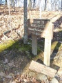
McQueen's Knob Shelter (3840') was built in 1934 and is an original AT log shelter. Today, it is no longer used as an official shelter and should only be used for emergencies. It has a dirt floor and no nearby water.
McQueen Gap Road[edit]
Last road access before reaching Damascus, VA. Parking is not advised here.
Abingdon Gap Shelter[edit]
Abingdon Gap Shelter (3773') is a concrete block shelter built by the United States Forest Service in 1959.
Backbone Rock Trail[edit]
Backbone Rock Trail is located 4.6 miles south of Damascus. It offers a 2.3 mile blue blaze trail on a narrow ridge from the AT to Backbone Rock Recreation Area which has camping and picnic facilities at a prominent rock wall which TN133 tunnels through just south of Damascus.
Tennessee/Virginia State Line[edit]
The "Welcome to Mount Rogers National Recreation Area" signifies entry into Virginia. It is a popular photo spot after the long ridge walk along Cross and Holston Mountains. As of Spring 2013, the TN/VA state line is now the official northern boundary of TEHCC-sponsored section of the Appalachian Trail. Mount Rogers Appalachian Trail Club sponsors the Trail from this point north through Damascus and the Grayson Highlands.
Photos[edit]
The old Mt. Rogers sign indicating the TN/VA border