Shelter:Overmountain: Difference between revisions
Jump to navigation
Jump to search
(Updating infobox information) |
(Removed statements now duplicate with infobox) |
||
| Line 20: | Line 20: | ||
== Description == | == Description == | ||
<!-- describe basic features, attraction, etc... --> | <!-- describe basic features, attraction, etc... --> | ||
Arguably the most unique shelter on the entire Appalachian Trail with | Arguably the most unique shelter on the entire Appalachian Trail with a great view looking down into Roaring Creek Valley. A classic wooden two-story barn built in the 1970s to meet the needs of a local farm, it was later converted to a shelter and renovated in the 1990s. The barn comfortably accommodates up to 30 people and is the only TEHCC shelter with a privy. | ||
== Location == | == Location == | ||
<!-- describe general location info --> | <!-- describe general location info --> | ||
Near Yellow Mountain Gap, between U.S. 19E and Carvers Gap | Near Yellow Mountain Gap, between U.S. 19E and Carvers Gap. The shelter is 0.3 miles east of AT. on a blue-blazed side trail. In the Pisgah National Forest, Toecane Ranger District. Located on the [[Carver's Gap to US19E]] section. | ||
== Water == | == Water == | ||
<!-- describe nearby water sources --> | <!-- describe nearby water sources --> | ||
Spring located on blue-blazed trail between shelter and AT | Spring located on blue-blazed trail between shelter and AT. | ||
== Maintenance History == | == Maintenance History == | ||
Revision as of 12:34, 30 April 2012

| ||
| Shelter | {{{Shelter}}} | |
| Capacity | 30 People | |
| Privy | Yes | |
| Trail Head Distance N | {{{DistanceN}}} Miles | |
| Trail Head Distance S | {{{DistanceS}}} Miles | |
| Elevation | 4,550 Feet | |
| Latitude | {{#lat_deg2dms: 36.123615}} | |
| Longitude | {{#long_deg2dms: -82.054214}} | |
| Nearest Medical | Elizabethton, TN | |
|
|
||
| Show Large Map | ||
Description
Arguably the most unique shelter on the entire Appalachian Trail with a great view looking down into Roaring Creek Valley. A classic wooden two-story barn built in the 1970s to meet the needs of a local farm, it was later converted to a shelter and renovated in the 1990s. The barn comfortably accommodates up to 30 people and is the only TEHCC shelter with a privy.
Location
Near Yellow Mountain Gap, between U.S. 19E and Carvers Gap. The shelter is 0.3 miles east of AT. on a blue-blazed side trail. In the Pisgah National Forest, Toecane Ranger District. Located on the Carver's Gap to US19E section.
Water
Spring located on blue-blazed trail between shelter and AT.
Maintenance History
- Mar 2006: Relocated privy. The platform was enlarged and placed over a 5'x4'x4' hole lined with rough sawn pine boards. Old hole with soil and logs.
- 2002: The "Older American" crew installed braces at each bottom end of the barn on the side where the sleeping areas are located. It should be more stable during wind events now.
- 1996: Framed the ground level and put in gravel to eliminate the dust. Covered the upstairs wall cracks to prevent entry of wind and rain. Built two sleeping platforms on the ground level. Built a bench upstairs. Painted the outside and installed a picnic table.
- 1995: Fred Lashley and Bob ? installed new roof.
- 1993: Reinforced structure in loft area. Dug ditch on back side, lined with plastic and filled with large rock for drainage. Enclosed stairwell and opening in loft with safety rails, cut door opening on ground level and installed bench upstairs.
Photo Gallery
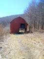
Overmountain Shelter
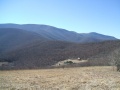
Viewing shelter from above

| Shelter name | Section | Trail distance from Damascus |
|---|---|---|
| Abingdon Gap Shelter | US421 to Damascus | 10.2 |
| McQueens Knob Shelter (emergency shelter) | US421 to Damascus | 11.7 |
| Double Springs Shelter | TN91 to US421 | 18.5 |
| Iron Mountain Shelter | Wilbur Dam Rd to TN91 | 26.2 |
| Vandeventer Shelter | Wilbur Dam Rd to TN91 | 33.0 |
| Laurel Fork Shelter | Dennis Cove Rd to Wilbur Dam Rd | 49.5 |
| Moreland Gap Shelter | US19E to Dennis Cove Rd | 57.0 |
| Mountaineer Falls Shelter | US19E to Dennis Cove Rd | 66.6 |
| Stan Murray Shelter | Carver's Gap to US19E | 86.5 |
| Roan High Knob Shelter | Iron Mountain Gap to Carver's Gap | 91.7 |
| Clyde Smith Shelter | Iron Mountain Gap to Carver's Gap | 100.2 |
| Cherry Gap Shelter | Indian Grave Gap to Iron Mountain Gap | 109.3 |
| Curley Maple Gap Shelter | Nolichucky River to Indian Grave Gap | 122.2 |
| No Business Knob Shelter | Spivey Gap to Nolichucky River | 132.7 |
Per the 2021 AT Data Book.