Shelter:No Business Knob: Difference between revisions
Jump to navigation
Jump to search
m (→Photo Gallery: Copying already uploaded image) |
(Filling in page) |
||
| Line 1: | Line 1: | ||
== Description == | == Description == | ||
<!-- describe basic features, attraction, etc... --> | <!-- describe basic features, attraction, etc... --> | ||
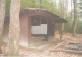
Basic three-sided concrete-block shelter with open front and wooden sleeping platform. | |||
From July 1994 newsletter, we learn that: “No Business Knob is named for a gentleman who tried to climb it a few years after a fire, when the top was impassable due to briars and brush. He decided that he had no business being there.” | |||
== Location == | == Location == | ||
<!-- describe general location info --> | <!-- describe general location info --> | ||
On the east slope of No Business Knob, between Nolichucky River and Spivey Gap. | |||
== Water == | == Water == | ||
<!-- describe nearby water sources --> | <!-- describe nearby water sources --> | ||
A spring is located about 200 yards trail-south on AT. | |||
== Maintenance History == | == Maintenance History == | ||
<!-- describe history of the shelter --> | <!-- describe history of the shelter --> | ||
*1997: Painted inside to remove grafitti. | |||
*1993: Painted inside and out. Painted roof (rust-proofed). Installed picnic table. | |||
*1990: Roof repaired. | |||
*1963: Built by US Forest Service. | |||
== Photo Gallery == | == Photo Gallery == | ||
<gallery> | <gallery> | ||
<!-- Place any pictures from this trail below. Add a picture by typing Image:imagename.extension --> | <!-- Place any pictures from this trail below. Add a picture by typing Image:imagename.extension --> | ||
Image: | Image: Spivey gap - no business knob shelter.jpg|No Business Knob Shelter | ||
</gallery> | </gallery> | ||
<!-- Do not remove the end gallery code.--> | <!-- Do not remove the end gallery code.--> | ||
{{Template:TEHCC Shelters}} | {{Template:TEHCC Shelters}} | ||
Revision as of 06:55, 14 April 2012
Description
Basic three-sided concrete-block shelter with open front and wooden sleeping platform.
From July 1994 newsletter, we learn that: “No Business Knob is named for a gentleman who tried to climb it a few years after a fire, when the top was impassable due to briars and brush. He decided that he had no business being there.”
Location
On the east slope of No Business Knob, between Nolichucky River and Spivey Gap.
Water
A spring is located about 200 yards trail-south on AT.
Maintenance History
- 1997: Painted inside to remove grafitti.
- 1993: Painted inside and out. Painted roof (rust-proofed). Installed picnic table.
- 1990: Roof repaired.
- 1963: Built by US Forest Service.
Photo Gallery
No Business Knob Shelter

| Shelter name | Section | Trail distance from Damascus |
|---|---|---|
| Abingdon Gap Shelter | US421 to Damascus | 10.2 |
| McQueens Knob Shelter (emergency shelter) | US421 to Damascus | 11.7 |
| Double Springs Shelter | TN91 to US421 | 18.5 |
| Iron Mountain Shelter | Wilbur Dam Rd to TN91 | 26.2 |
| Vandeventer Shelter | Wilbur Dam Rd to TN91 | 33.0 |
| Laurel Fork Shelter | Dennis Cove Rd to Wilbur Dam Rd | 49.5 |
| Moreland Gap Shelter | US19E to Dennis Cove Rd | 57.0 |
| Mountaineer Falls Shelter | US19E to Dennis Cove Rd | 66.6 |
| Stan Murray Shelter | Carver's Gap to US19E | 86.5 |
| Roan High Knob Shelter | Iron Mountain Gap to Carver's Gap | 91.7 |
| Clyde Smith Shelter | Iron Mountain Gap to Carver's Gap | 100.2 |
| Cherry Gap Shelter | Indian Grave Gap to Iron Mountain Gap | 109.3 |
| Curley Maple Gap Shelter | Nolichucky River to Indian Grave Gap | 122.2 |
| No Business Knob Shelter | Spivey Gap to Nolichucky River | 132.7 |
Per the 2021 AT Data Book.