Shelter:Mountaineer Falls: Difference between revisions
(Added shelter picture) |
m (→Maintenance History: Oct 2017) |
||
| (11 intermediate revisions by 3 users not shown) | |||
| Line 1: | Line 1: | ||
<!-- | <!-- The following few lines create the "Infobox" table template. Please scroll down to edit the main content of the article. --> | ||
{{Infobox Shelter | |||
| Image Name = Mountaineer Falls Shelter1.jpg | |||
| Shelter = Mountaineer Falls | |||
| Capacity = 14 | |||
| Privy = No | |||
| DistanceN = 1.6 | |||
| DistanceS = 5.2 | |||
| Elevation = 3,200 | |||
| Latitude = 36.2202 | |||
| Longitude = -81.98569 | |||
| Medical = Elizabethton, TN | |||
}} | |||
<!-- End Infobox template table--> | |||
<!-- Start of Main Page --> | |||
== Description == | == Description == | ||
<!-- describe basic features, attraction, etc... --> | <!-- describe basic features, attraction, etc... --> | ||
The newest shelter on the TEHCC section of the Appalachian Trail. Located near its name-sake Mountaineer Falls. A wooden A-frame with two main sleeping platforms and one loft platform | The newest shelter on the TEHCC section of the Appalachian Trail. Located near its name-sake Mountaineer Falls. A wooden A-frame with two main sleeping platforms and one loft platform. | ||
== Location == | == Location == | ||
<!-- describe general location info --> | <!-- describe general location info --> | ||
Located between Elk River and Walnut Mountain Road | Located between Elk River and Walnut Mountain Road. The shelter is 70 yards off the AT on a blue-blazed side trail. In the Cherokee National Forest, Watauga Ranger District. Located on the [[US19E to Dennis Cove Rd]] section. | ||
== Water == | == Water == | ||
<!-- describe nearby water sources --> | <!-- describe nearby water sources --> | ||
The nearest water source is Mountaineer Falls. Either continue on the blue blaze from the shelter to the top of the falls, or follow the | The nearest water source is Mountaineer Falls. Either continue on the blue blaze from the shelter to the top of the falls, or follow the AT south of the shelter to the bottom of the falls. | ||
== Maintenance History == | == Maintenance History == | ||
<!-- describe history of the shelter --> | <!-- describe history of the shelter --> | ||
*2006: Built by the TEHCC and Hardcore Crew | *Oct 2017: Partial repainting (ran out of paint) and installed graffiti board. | ||
*May 2006: Built by the TEHCC and Hardcore Crew | |||
*Aug 2007: Trail distance measured by Collins Chew | |||
== Photo Gallery == | == Photo Gallery == | ||
| Line 25: | Line 37: | ||
<gallery> | <gallery> | ||
<!-- Place any pictures from this trail below. Add a picture by typing Image:imagename.extension --> | <!-- Place any pictures from this trail below. Add a picture by typing Image:imagename.extension --> | ||
Image:Mountaineer Falls Shelter1.jpg | Image:Mountaineer Falls Shelter1.jpg|Mountaineer Falls Shelter | ||
Image: | Image:Mountaineer Falls Shelter2.jpg|View of top "third" floor | ||
Image:Mountaineer Falls Shelter3.jpg|Ladders to second and third sleeping decks | |||
Image:MFSBear.jpg|Wood-carved bear at Mountaineer Falls Shelter | |||
</gallery> | </gallery> | ||
<!-- Do not remove the end gallery code.--> | <!-- Do not remove the end gallery code.--> | ||
{{Template:TEHCC Shelters}} | {{Template:TEHCC Shelters}} | ||
Latest revision as of 05:21, 30 October 2017

| ||
| Shelter | Mountaineer Falls | |
| Capacity | 14 People | |
| Privy | No | |
| Trail Head Distance N | 1.6 Miles | |
| Trail Head Distance S | 5.2 Miles | |
| Elevation | 3,200 Feet | |
| Latitude | {{#lat_deg2dms: 36.2202}} | |
| Longitude | {{#long_deg2dms: -81.98569}} | |
| Nearest Medical | Elizabethton, TN | |
|
|
||
| Show Large Map | ||
Description[edit]
The newest shelter on the TEHCC section of the Appalachian Trail. Located near its name-sake Mountaineer Falls. A wooden A-frame with two main sleeping platforms and one loft platform.
Location[edit]
Located between Elk River and Walnut Mountain Road. The shelter is 70 yards off the AT on a blue-blazed side trail. In the Cherokee National Forest, Watauga Ranger District. Located on the US19E to Dennis Cove Rd section.
Water[edit]
The nearest water source is Mountaineer Falls. Either continue on the blue blaze from the shelter to the top of the falls, or follow the AT south of the shelter to the bottom of the falls.
Maintenance History[edit]
- Oct 2017: Partial repainting (ran out of paint) and installed graffiti board.
- May 2006: Built by the TEHCC and Hardcore Crew
- Aug 2007: Trail distance measured by Collins Chew
Photo Gallery[edit]
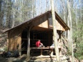
Mountaineer Falls Shelter
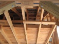
View of top "third" floor
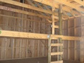
Ladders to second and third sleeping decks
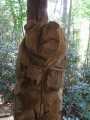
Wood-carved bear at Mountaineer Falls Shelter


| Shelter name | Section | Trail distance from Damascus |
|---|---|---|
| Abingdon Gap Shelter | US421 to Damascus | 10.2 |
| McQueens Knob Shelter (emergency shelter) | US421 to Damascus | 11.7 |
| Double Springs Shelter | TN91 to US421 | 18.5 |
| Iron Mountain Shelter | Wilbur Dam Rd to TN91 | 26.2 |
| Vandeventer Shelter | Wilbur Dam Rd to TN91 | 33.0 |
| Laurel Fork Shelter | Dennis Cove Rd to Wilbur Dam Rd | 49.5 |
| Moreland Gap Shelter | US19E to Dennis Cove Rd | 57.0 |
| Mountaineer Falls Shelter | US19E to Dennis Cove Rd | 66.6 |
| Stan Murray Shelter | Carver's Gap to US19E | 86.5 |
| Roan High Knob Shelter | Iron Mountain Gap to Carver's Gap | 91.7 |
| Clyde Smith Shelter | Iron Mountain Gap to Carver's Gap | 100.2 |
| Cherry Gap Shelter | Indian Grave Gap to Iron Mountain Gap | 109.3 |
| Curley Maple Gap Shelter | Nolichucky River to Indian Grave Gap | 122.2 |
| No Business Knob Shelter | Spivey Gap to Nolichucky River | 132.7 |
Per the 2021 AT Data Book.