Shelter:Laurel Fork: Difference between revisions
Jump to navigation
Jump to search
(Update IB to new format) |
(Added another pix) |
||
| Line 1: | Line 1: | ||
<!-- The following few lines create the "Infobox" table template. Please scroll down to edit the main content of the article. --> | <!-- The following few lines create the "Infobox" table template. Please scroll down to edit the main content of the article. --> | ||
{{Infobox Shelter | {{Infobox Shelter | ||
| Image Name = Laurel Fork Shelter | | Image Name = Laurel Fork Shelter.JPG | ||
| Shelter = Laurel Fork | | Shelter = Laurel Fork | ||
| Capacity = 6 | | Capacity = 6 | ||
| Line 17: | Line 17: | ||
== Description == | == Description == | ||
<!-- describe basic features, attraction, etc... --> | <!-- describe basic features, attraction, etc... --> | ||
Three-sided shelter built out of native stone with open front and wooden sleeping platform. | Three-sided shelter built out of native stone with open front and wooden sleeping platform located high above the Laurel Fork Creek. | ||
== Location == | == Location == | ||
| Line 25: | Line 25: | ||
== Water == | == Water == | ||
<!-- describe nearby water sources --> | <!-- describe nearby water sources --> | ||
A cascading stream is located 150 feet on blue-blazed trail behind the shelter. | |||
== Maintenance History == | == Maintenance History == | ||
| Line 36: | Line 36: | ||
<gallery> | <gallery> | ||
<!-- Place any pictures from this trail below. Add a picture by typing Image:imagename.extension --> | <!-- Place any pictures from this trail below. Add a picture by typing Image:imagename.extension --> | ||
Image:Laurel Fork Shelter-3.jpg | Image:Laurel Fork Shelter-3.jpg|Laurel Fork Shelter | ||
Image:Laurel Fork Shelter sleeping platform.jpg|New platform installed | Image:Laurel Fork Shelter sleeping platform.jpg|New platform installed | ||
Image:Laurel Fork Shelter-1|Laurel Fork Shelter | |||
Image: | |||
</gallery> | </gallery> | ||
<!-- Do not remove the end gallery code.--> | <!-- Do not remove the end gallery code.--> | ||
{{Template:TEHCC Shelters}} | {{Template:TEHCC Shelters}} | ||
Revision as of 15:30, 4 July 2012

| ||
| Shelter | Laurel Fork | |
| Capacity | 6 People | |
| Privy | No | |
| Trail Head Distance N | 7.0 Miles | |
| Trail Head Distance S | 1.9 Miles | |
| Elevation | 2,450 Feet | |
| Latitude | {{#lat_deg2dms: 36.278642}} | |
| Longitude | {{#long_deg2dms: -82.136229}} | |
| Nearest Medical | Elizabethton, TN | |
|
|
||
| Show Large Map | ||
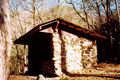
Description
Three-sided shelter built out of native stone with open front and wooden sleeping platform located high above the Laurel Fork Creek.
Location
In Laurel Fork Gorge, between US321 and Dennis Cove Road. The shelter is 300 feet uphill off the AT on a blue-blazed side trail.
Water
A cascading stream is located 150 feet on blue-blazed trail behind the shelter.
Maintenance History
- Feb 2008: Repaired plywood platform.
- 1994: Installed picnic table.
- 1960: Built by US Forest Service.
Photo Gallery
Laurel Fork Shelter
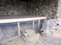
New platform installed
- Laurel Fork Shelter-1
Laurel Fork Shelter


| Shelter name | Section | Trail distance from Damascus |
|---|---|---|
| Abingdon Gap Shelter | US421 to Damascus | 10.2 |
| McQueens Knob Shelter (emergency shelter) | US421 to Damascus | 11.7 |
| Double Springs Shelter | TN91 to US421 | 18.5 |
| Iron Mountain Shelter | Wilbur Dam Rd to TN91 | 26.2 |
| Vandeventer Shelter | Wilbur Dam Rd to TN91 | 33.0 |
| Laurel Fork Shelter | Dennis Cove Rd to Wilbur Dam Rd | 49.5 |
| Moreland Gap Shelter | US19E to Dennis Cove Rd | 57.0 |
| Mountaineer Falls Shelter | US19E to Dennis Cove Rd | 66.6 |
| Stan Murray Shelter | Carver's Gap to US19E | 86.5 |
| Roan High Knob Shelter | Iron Mountain Gap to Carver's Gap | 91.7 |
| Clyde Smith Shelter | Iron Mountain Gap to Carver's Gap | 100.2 |
| Cherry Gap Shelter | Indian Grave Gap to Iron Mountain Gap | 109.3 |
| Curley Maple Gap Shelter | Nolichucky River to Indian Grave Gap | 122.2 |
| No Business Knob Shelter | Spivey Gap to Nolichucky River | 132.7 |
Per the 2021 AT Data Book.