Shelter:Clyde Smith: Difference between revisions
Jump to navigation
Jump to search
(→Description: Namesake) |
|||
| (20 intermediate revisions by 2 users not shown) | |||
| Line 1: | Line 1: | ||
<!-- The following few lines create the "Infobox" table template. Please scroll down to edit the main content of the article. --> | |||
{{Infobox Shelter | |||
| Image Name = Clyde Smith Shelter.jpg | |||
| Shelter = Clyde Smith | |||
| Capacity = 10 | |||
| Privy = No | |||
| DistanceN = 3.3 | |||
| DistanceS = 6.1 | |||
| Elevation = 4,600 | |||
| Latitude = 36.148533 | |||
| Longitude = -82.161184 | |||
| Medical = Erwin, TN | |||
}} | |||
<!-- End Infobox template table--> | |||
<!-- Start of Main Page --> | |||
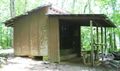
== Description == | == Description == | ||
<!-- describe basic features, attraction, etc... --> | <!-- describe basic features, attraction, etc... --> | ||
Three-sided wood shelter with metal roof – and covered front porch. | Three-sided wood shelter with metal roof – and covered front porch. Named for a prolific maker of wooden signs for the AT, primarily in the White Mountains of New Hampshire and this area of Tennessee. | ||
== Location == | == Location == | ||
<!-- describe general location info --> | <!-- describe general location info --> | ||
Trail-south of Little Rock Knob, between Hughes Gap and Iron Mountain Gap. The shelter is | Trail-south of Little Rock Knob, between [[Iron Mountain Gap to Carver's Gap|Hughes Gap and Iron Mountain Gap]]. The shelter is 120 yards (measured August 2014) from the AT on a blue-blazed side trail. | ||
== Water == | == Water == | ||
<!-- describe nearby water sources --> | <!-- describe nearby water sources --> | ||
A spring is located | A spring is located 205 yards (measured August 2014) west of the shelter down a steep hill. It consists of a buried drum for water collection which overflows from a 2" plastic pipe for easier filling of water bottles. | ||
== Maintenance History == | == Maintenance History == | ||
<!-- describe history of the shelter --> | <!-- describe history of the shelter --> | ||
* | *Oct 2016: Painted the shelter outside. Significant sealing of roof on both inside and outside to hopefully eliminate couple of long term leaks. | ||
*May 2002: | *2012: Caulked all roof screws. | ||
*May 2009: Eagle project improved the spring water source. [http://tehcc.org/pdf/newsletters/news200910.pdf TEHCC newsletter article] | |||
*May 2002: Remodeled from floor up during Hard Core event. Porch with eating area and upper level bunks were added. | |||
*Nov 1993: Roof extended by 2 ft and sides added to reduce the probability of rain blowing into the shelter. | *Nov 1993: Roof extended by 2 ft and sides added to reduce the probability of rain blowing into the shelter. | ||
* | *1976: Built by U.S. Forest Service. | ||
== Photo Gallery == | == Photo Gallery == | ||
<gallery> | <gallery> | ||
<!-- Place any pictures from this trail below. Add a picture by typing Image:imagename.extension --> | <!-- Place any pictures from this trail below. Add a picture by typing Image:imagename.extension --> | ||
Image: Clyde Smith Shelter.jpg | Image: Clyde Smith Shelter.jpg|Pre-2012 | ||
Image: Clyde_Smith_Shelter_water_source.JPG|Water supply | |||
Image: Clyde_Smith_Shelter_sleeping_platform_view.JPG|Sleeping platform | |||
Image: Clyde_Smith_Shelter_north_view.JPG|North side view with Fire ring | |||
Image: Clyde_Smith_Shelter_August2014.JPG|August 2014 | |||
</gallery> | </gallery> | ||
<!-- Do not remove the end gallery code.--> | <!-- Do not remove the end gallery code.--> | ||
{{Template:TEHCC Shelters}} | {{Template:TEHCC Shelters}} | ||
Latest revision as of 14:37, 3 June 2019

| ||
| Shelter | Clyde Smith | |
| Capacity | 10 People | |
| Privy | No | |
| Trail Head Distance N | 3.3 Miles | |
| Trail Head Distance S | 6.1 Miles | |
| Elevation | 4,600 Feet | |
| Latitude | {{#lat_deg2dms: 36.148533}} | |
| Longitude | {{#long_deg2dms: -82.161184}} | |
| Nearest Medical | Erwin, TN | |
|
|
||
| Show Large Map | ||
Description[edit]
Three-sided wood shelter with metal roof – and covered front porch. Named for a prolific maker of wooden signs for the AT, primarily in the White Mountains of New Hampshire and this area of Tennessee.
Location[edit]
Trail-south of Little Rock Knob, between Hughes Gap and Iron Mountain Gap. The shelter is 120 yards (measured August 2014) from the AT on a blue-blazed side trail.
Water[edit]
A spring is located 205 yards (measured August 2014) west of the shelter down a steep hill. It consists of a buried drum for water collection which overflows from a 2" plastic pipe for easier filling of water bottles.
Maintenance History[edit]
- Oct 2016: Painted the shelter outside. Significant sealing of roof on both inside and outside to hopefully eliminate couple of long term leaks.
- 2012: Caulked all roof screws.
- May 2009: Eagle project improved the spring water source. TEHCC newsletter article
- May 2002: Remodeled from floor up during Hard Core event. Porch with eating area and upper level bunks were added.
- Nov 1993: Roof extended by 2 ft and sides added to reduce the probability of rain blowing into the shelter.
- 1976: Built by U.S. Forest Service.
Photo Gallery[edit]
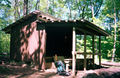
Pre-2012
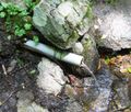
Water supply
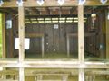
Sleeping platform
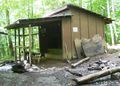
North side view with Fire ring
August 2014


| Shelter name | Section | Trail distance from Damascus |
|---|---|---|
| Abingdon Gap Shelter | US421 to Damascus | 10.2 |
| McQueens Knob Shelter (emergency shelter) | US421 to Damascus | 11.7 |
| Double Springs Shelter | TN91 to US421 | 18.5 |
| Iron Mountain Shelter | Wilbur Dam Rd to TN91 | 26.2 |
| Vandeventer Shelter | Wilbur Dam Rd to TN91 | 33.0 |
| Laurel Fork Shelter | Dennis Cove Rd to Wilbur Dam Rd | 49.5 |
| Moreland Gap Shelter | US19E to Dennis Cove Rd | 57.0 |
| Mountaineer Falls Shelter | US19E to Dennis Cove Rd | 66.6 |
| Stan Murray Shelter | Carver's Gap to US19E | 86.5 |
| Roan High Knob Shelter | Iron Mountain Gap to Carver's Gap | 91.7 |
| Clyde Smith Shelter | Iron Mountain Gap to Carver's Gap | 100.2 |
| Cherry Gap Shelter | Indian Grave Gap to Iron Mountain Gap | 109.3 |
| Curley Maple Gap Shelter | Nolichucky River to Indian Grave Gap | 122.2 |
| No Business Knob Shelter | Spivey Gap to Nolichucky River | 132.7 |
Per the 2021 AT Data Book.