Shelter:Abingdon Gap: Difference between revisions
Jump to navigation
Jump to search
(Expanded shelter information) |
(/* Photo Gallery/ Added photo of water source from TEHCC image folder) |
||
| Line 24: | Line 24: | ||
<!-- Place any pictures from this trail below. Add a picture by typing Image:imagename.extension --> | <!-- Place any pictures from this trail below. Add a picture by typing Image:imagename.extension --> | ||
Image: New Sleeping Platform at Abingdon Gap Shelter.jpg|New Sleeping Platform | Image: New Sleeping Platform at Abingdon Gap Shelter.jpg|New Sleeping Platform | ||
Image: Abingdon_Gap_Shelter_spring_Apr2007.jpg|Water Source (April 2007) | |||
</gallery> | </gallery> | ||
<!-- Do not remove the end gallery code.--> | <!-- Do not remove the end gallery code.--> | ||
{{Template:TEHCC Shelters}} | {{Template:TEHCC Shelters}} | ||
Revision as of 21:02, 12 April 2012
Description
Basic three-sided concrete block shelter with picnic table out front.
Location
In Maple Springs Gap, just over ten miles south of Damascus.
Water
A spring is located 275 yards below the shelter, which has two pipes. Flow depends on rainfall during the prior week. During summer, the spring may dry up, thus plan on packing in water.
Maintenance History
- Currently being checked by “Just Jim”.
- Apr 2007: Complete replacement the sleeping platform (thanks to grant from L.L. Bean). Also repaired water source by installing new pipe and cleaning out the pools.
- May 2003: Roof leak fixed.
- Nov 1992: New metal roof installed (thanks to Forest Service funding), along with donated picnic table carried to shelter.
- 1959: Built by US Forest Service.
Photo Gallery
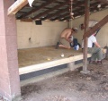
New Sleeping Platform
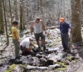
Water Source (April 2007)


| Shelter name | Section | Trail distance from Damascus |
|---|---|---|
| Abingdon Gap Shelter | US421 to Damascus | 10.2 |
| McQueens Knob Shelter (emergency shelter) | US421 to Damascus | 11.7 |
| Double Springs Shelter | TN91 to US421 | 18.5 |
| Iron Mountain Shelter | Wilbur Dam Rd to TN91 | 26.2 |
| Vandeventer Shelter | Wilbur Dam Rd to TN91 | 33.0 |
| Laurel Fork Shelter | Dennis Cove Rd to Wilbur Dam Rd | 49.5 |
| Moreland Gap Shelter | US19E to Dennis Cove Rd | 57.0 |
| Mountaineer Falls Shelter | US19E to Dennis Cove Rd | 66.6 |
| Stan Murray Shelter | Carver's Gap to US19E | 86.5 |
| Roan High Knob Shelter | Iron Mountain Gap to Carver's Gap | 91.7 |
| Clyde Smith Shelter | Iron Mountain Gap to Carver's Gap | 100.2 |
| Cherry Gap Shelter | Indian Grave Gap to Iron Mountain Gap | 109.3 |
| Curley Maple Gap Shelter | Nolichucky River to Indian Grave Gap | 122.2 |
| No Business Knob Shelter | Spivey Gap to Nolichucky River | 132.7 |
Per the 2021 AT Data Book.