Search results
Jump to navigation
Jump to search
Page title matches
- ...OLETE" are not to be used and should be deleted in the usage if updating a trail page. They are left here for backward compatibility and will be removed onc {{Infobox Trail6 KB (844 words) - 11:01, 20 November 2018
- {{Trail |Banner Image=File:Lakeside Trail - Bays Mountain Dam.jpg4 KB (663 words) - 17:12, 19 March 2023
- Below are the images seen on the trail infoboxes, what they mean, and how to use them if you edit trails. !Name in trail editing lists2 KB (295 words) - 15:22, 6 October 2019
- -->{{Infobox Trail | Trail Use = {{Hike}} {{Skiing}}4 KB (508 words) - 11:21, 21 November 2015
- {{Trail |Trail Highlight=Access to the Sand Cave and White Rocks (the colloquially known n7 KB (1,173 words) - 23:19, 27 November 2019
- <noinclude>This returns a map of the trails associated with the trail page it is called on. {{Trail Map|Main Trail={{PAGENAME}}|Other Trails= |Zoom Cancel=[any entry will trigger cancel]}}8 KB (992 words) - 13:30, 23 March 2023
- {{Trail |Trail Marking=Signs2 KB (265 words) - 23:30, 15 December 2019
- {{Trail |Trail Highlight=Connects Lakeside Trail with Lake Road2 KB (281 words) - 15:51, 15 December 2019
- {{Trail |Banner Image=File:BMP Azalea Trail.JPG3 KB (372 words) - 20:34, 12 April 2023
- {{Trail |Trail Marking=Signs2 KB (262 words) - 17:03, 15 December 2019
- {{Trail |Trail Marking=Signs2 KB (295 words) - 20:07, 15 December 2019
- {{Trail |Banner Image=File:BMP Orchid Trail sign.JPG2 KB (294 words) - 19:17, 15 December 2019
- {{Trail |Banner Image=File:BMP Cliffside Trail view from obs tower towards firetower.JPG4 KB (520 words) - 22:48, 14 December 2019
- ...ieces will provide background information to allow more folks to enjoy the trail.6 members (0 subcategories, 0 files) - 05:48, 16 April 2012
- ...on of a trail (including park page defined stubs). Its expected use is for trail tables and map balloons.193 bytes (34 words) - 15:36, 24 November 2019
- {{Trail |Banner Image=File:BMP Chinquapin Trail.JPG3 KB (448 words) - 20:49, 14 December 2019
- #REDIRECT [[Barred Owl Trail]]30 bytes (4 words) - 20:34, 12 April 2023
- This trail name is used by more than one park. * [[Lake Trail (Big Ridge State Park)]]181 bytes (29 words) - 23:36, 30 November 2019
- {{Trail |Trail Highlight=5,560' summit with view of northern highlands6 KB (930 words) - 22:36, 2 December 2019
- {{Trail |Trail Marking=Signs3 KB (468 words) - 14:50, 14 December 2019
Page text matches
- {{Trail |Banner Image=File:BMP Firetower Trail tower.jpg4 KB (529 words) - 22:07, 10 December 2019
- !Trail distance from Damascus1 KB (201 words) - 18:24, 20 February 2023
- ...distance, thus reported for annual data book update. This page, like the trail itself, is a work in progress to figure out how to best use the available t <br>- Backbone Rock Trail (blue blaze)7 KB (1,010 words) - 12:12, 7 January 2023
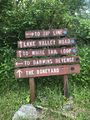
File:WPSP Main Split signs.JPG |Trail=Boneyard, Lake Road (Warriors Path State Park), Whitetail Loop, Zipline |Caption=Signs at main trail split(3,024 × 4,032 (4.76 MB)) - 11:45, 24 June 2023- Arguably the most unique shelter on the entire Appalachian Trail with a great view looking down into Roaring Creek Valley. A classic wooden ...d Carvers Gap. The shelter is 0.3 miles east of AT. on a blue-blazed side trail. In the Pisgah National Forest, Toecane Ranger District. Located on the [[C4 KB (605 words) - 07:28, 20 November 2023
- Water is found 100 yards from the shelter on a blue blaze trail. <!-- Place any pictures from this trail below. Add a picture by typing Image:imagename.extension -->2 KB (282 words) - 12:04, 21 December 2018
- ...il' template. It is expected to be typically used by the [[Form:Trail|Form Trail]]. This template creates the 'sidebar' with info about each trail like the state, nearest city, coordinates of the tail head. If not used, en9 KB (1,166 words) - 19:07, 15 April 2023
- <!-- Add additional columns for distance from Bristol/trail distance/AT or branch --> !Trail5 KB (506 words) - 17:26, 10 June 2023
- {{Trail |Trail Marking=Blue7 KB (1,046 words) - 15:35, 10 January 2023
- {{Trail |Trail Highlight=Your likely trail if you want to "go to The Channels"6 KB (906 words) - 10:47, 8 January 2023
File:The Great Channels1.jpg |Trail=The Channels Natural Area Preserve(768 × 1,024 (139 KB)) - 22:39, 15 November 2018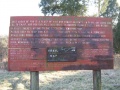
File:Sinking Waters information sign.jpg |Trail=Sinking Waters(768 × 576 (123 KB)) - 15:07, 20 November 2018- |Trail Map Link=https://www.baysmountain.com/wp-content/uploads/BMP-Trail-Nature-Center-Grounds-Map-Georeferenced-20240503.pdf 36.50803,-82.61255~Lakeside Trail~ ~MarkerG.png9 KB (1,286 words) - 17:10, 24 May 2024
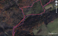
File:Comparison of etrex and forerunner logging.PNG ...nta/pink. The eTrex track was more consistent upon trail returns and known trail locations/shape.(1,566 × 974 (3.49 MB)) - 00:39, 2 January 2020- {{Trail |Banner Image=File:Lakeside Trail - Bays Mountain Dam.jpg4 KB (663 words) - 17:12, 19 March 2023
- == Getting started adding a trail page == Steps to creating a new trail (or filling out a referenced one that has no page)10 KB (1,857 words) - 17:31, 8 March 2020
File:Sinking Waters sinkhole.jpg |Trail=Sinking Waters(2,048 × 1,536 (910 KB)) - 12:24, 19 November 2018- |Trail Map Link=https://tnstateparks.com/assets/pdf/additional-content/park-maps/4 |Park Trail Count=9 KB (1,271 words) - 11:59, 19 September 2021
- {{Trail |Trail Highlight=Three connected loops and a stream that disappears into a sinkhol9 KB (1,357 words) - 17:53, 14 December 2019
- |Trail Condition=Clear |Trail Comment=Good. Some decking felt loose and handrail is knocked off in wetlan520 bytes (81 words) - 10:42, 8 December 2018


