Cliffside Trail
| Cliffside Trail (log in to submit report) | |
|---|---|

| |
| Park | Bays Mountain Park |
| Land Owner | City of Kingsport |
| Located | Kingsport, TennesseeLocation inherited from associated park |
| Trail Marking | Signs |
| Trail UseThings allowed to do on or near the trail |
|
| FeaturesThings to see on or near the trail |
|
| Difficulty Rating | Medium |
| Hiking TimeTime from car and back. Includes any time hiking to access this trail. | 30 min0.5 Hours <br />0.0313 Days <br /> round trip |
| Distance: | 0.76 mi1.223 km <br /> trailStrict non-repeating trail length / 1.0 mi1.609 km <br /> round tripTypical or shortest length from the car, hike the trail, and return to car |
| Trail Type | Segment |
| Low / High Point | 1,858 ft619.333 Yards <br />566.318 Meters <br /> / 2,172 ft724 Yards <br />662.026 Meters <br /> |
| Elev. Gain/LossSee link for details of calculation. Gain/Loss is direction dependent. | 308 ft93.878 Meters <br /> / (188 ft57.302 Meters <br />) – West-to-East |
| Trip ReportsFrom user "hiked it" submissions<br />Recent is within last 90 days | 1 logged hikes (0 recent) |
| NearbyWithin 5 mi<br />Click link to view list | 30 trails / 37.7 mi of trail |
| Parking | 36° 30' 31.75" N, 82° 36' 34.38" W Map |
| Trailhead | 36° 30' 29.23" N, 82° 36' 39.06" W Map |
|
| |
| Show In Google Maps | |
Download KML / Upload new version / KML File Page / GeoJson Page / Create Profile Chart / gpsvisualizer Map
Trail Overview
Located in Bays Mountain Park. Up and along the ridgeline to a lookout tower.
How to get there
From the main parking lot, head over to the observatory. The unmarked trail heads uphill from here. Alternatively, head up Bays Mountain Road to observation tower and take the trail back down.
Route Description

Short steep hike along the ridgeline with couple of lookout points and up to the observation tower.
This trail has connections to Bays Mountain Road.
| Miles | Cliffside Trail | Miles |
|---|---|---|
| 0.0 | Trailhead at Astronomical Observatory. Also first overlook nearby. | 0.5 |
| 0.1 | Overlook near gate on Bays Mountain Road | 0.4 |
| 0.2 | Trail split. Up stairs is older route. Ahead is newer side trail alternative shown on park map. | 0.3 |
| 0.4 | Trail split on ridge line. Down is newer side trail alternative shown on park map, while follow ridge to older route. | 0.1 |
| 0.5 | Observation Tower/Junction with Bays Mountain Road | 0.0 |
Typical Conditions
The older trail route is very worn and washed out on steep ascent with stone steps built long ago. Pine needle covered path once up on ridge line. Alternate route is newer side hill trail in excellent condition.
Regulations
NO BIKES!
Misc. Information
Selective removal of some trees around the lookout tower would greatly improve viewing year around.
Photos
-
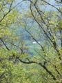
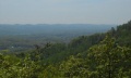 View from higher overlook along trail
 -
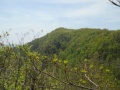 View from the lower overlook along trail
 -
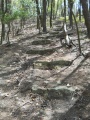 Older steps up Cliffside Trail
 -
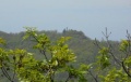 View from observation tower towards firetower
 -
 View from obs tower towards valley
 -
 Trail Profile


