|
|
| (9 intermediate revisions by 2 users not shown) |
| Line 1: |
Line 1: |
| <!-- The following few lines create the "Infobox" table template. Please scroll down to edit the main content of the article. -->
| | {{Trail |
| {{Infobox ATSection | | |Banner Image=File:RoaringForkValley.jpg |
| | Image Name = RoaringForkValley.jpg
| | |Trail System=Appalachian Trail |
| | Section = 13-14abc
| | |City=Roan Mountain |
| | Trail_south = Carver's Gap
| | |Land Owner=Cherokee National Forest |
| | Trail_north = US 19E
| | |Trail Marking=White |
| | Distance = 14.8
| | |Trail Use=Hiking, Camping |
| | Min_elevation = 2,895
| | |Trail Features=Vistas, Mountains |
| | Max_elevation = 5,826
| | |Difficulty Rating=Medium |
| | Governing = Appalachian/ Watauga north of Doll Flats
| | |Hike Time=5 hrs |
| | Latitude = 36.10636
| | |Trail Distance=14.8 mi |
| | Longitude = -82.1105648
| | |Round Trip Distance=29.6 mi |
| | |Trail Type=In-and-Out |
| | |High Point=5,886 ft |
| | |Low Point=2,859 ft |
| | |Elevation Gain=2,054 ft |
| | |Elevation Loss=4,703 ft |
| | |Elevation Change Direction=South-to-North |
| | |Parking location=36.10636, -82.11056 |
| | |Trailhead location=36.10636, -82.11056 |
| }} | | }} |
| <!-- End Infobox template table-->
| | {{Trail Map|Main Trail=Carver's Gap to US19E}} |
| | |
| | __TOC__ |
| | |
| | == Trail Overview == |
| | |
| | == How to get there == |
| | |
| | == Route Description == |
|
| |
|
| (Trail South > North) | | (Trail South > North) |
|
| |
|
| == Carvers Gap == | | === Carvers Gap === |
|
| |
|
| Carvers Gap (5512') is the primary road access for the Roan Highlands. TN143 comes from Roan Mountain, TN and NC261 comes from Bakersville, NC. Large parking area with restrooms. The road to the top of Roan Mountain is open from approximately May-October. | | Carvers Gap (5512') is the primary road access for the Roan Highlands. TN143 comes from Roan Mountain, TN and NC261 comes from Bakersville, NC. Large parking area with restrooms. The road to the top of Roan Mountain is open from approximately May-October. |
|
| |
|
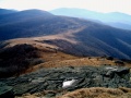
| == Round Bald == | | === Round Bald === |
|
| |
|
| Round Bald (5826') is one of the many famous balds of the Roan Highlands. Round Bald has 360 degree views from its summit. Round Bald is also home to one of the TEHCC's greatest trail maintenance projects - hardened gravel and geotextile over 1 mile of the Trail. This project was completed in 2001. | | Round Bald (5826') is one of the many famous balds of the Roan Highlands. Round Bald has 360 degree views from its summit. Round Bald is also home to one of the TEHCC's greatest trail maintenance projects - hardened gravel and geotextile over 1 mile of the Trail. This project was completed in 2001. |
|
| |
|
| == Jane Bald == | | === Jane Bald === |
|
| |
|
| Jane Bald (5807') is another Roan Highlands bald. It's name is derived from Jane Cook whose sister Harriet died of milk sickness on the bald in November of 1870. | | Jane Bald (5807') is another Roan Highlands bald. It's name is derived from Jane Cook whose sister Harriet died of milk sickness on the bald in November of 1870. |
|
| |
|
| == Grassy Ridge Side Trail == | | === Grassy Ridge Side Trail === |
|
| |
|
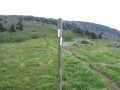
| The [[Grassy Ridge]] side trail leads 0.5 miles to the summit. A plaque, located at the summit, is dedicated to Cornelius Rex Peake who owned and donated much of the mountain. The Grassy Ridge summit is a part of the [http://tehcc.org/hiking/challenges/south-beyond-6000/ South Beyond 6000 Challenge]. | | The [[Grassy Ridge]] side trail leads 0.5 miles to the summit. A plaque, located at the summit, is dedicated to Cornelius Rex Peake who owned and donated much of the mountain. The Grassy Ridge summit is a part of the [http://tehcc.org/hiking/challenges/south-beyond-6000/ South Beyond 6000 Challenge]. |
|
| |
|
| == Shelters == | | === Shelter === |
| *[[Shelter:Stan Murray|Stan Murray Shelter]] | | *[[Shelter:Stan Murray|Stan Murray Shelter]] |
| *[[Shelter:Overmountain|Overmountain Shelter]] (Yellow Mountain Barn)
| |
| *[[Shelter:Apple House|Apple House Shelter]] - Dismantled 2012 - now camping spots
| |
|
| |
|
| == Overmountain Victory Trail == | | === Overmountain Victory Trail === |
|
| |
|
| The [[Overmountain Victory National Historic Trail|Overmountain Victory Trail]] crosses the AT at Yellow Mountain Gap and offers an alternate from Roaring Creek Valley. This is a part of the original 330 mile route used by the Revolutionary War frontiersmen that traveled from Abingdon, VA to Kings Mountain, NC/SC where they defeated the Loyalists. The route officially starts as a walking trail at Hampton Creek Cove State Natural Area outside of Roan Mountain, TN and connects to Roaring Creek, NC. OVTA members can be seen walking this route in the Fall in remembrance of the 1780 march. | | The [[Overmountain Victory National Historic Trail|Overmountain Victory Trail]] crosses the AT at Yellow Mountain Gap and offers an alternate from Roaring Creek Valley. This is a part of the original 330 mile route used by the Revolutionary War frontiersmen that traveled from Abingdon, VA to Kings Mountain, NC/SC where they defeated the Loyalists. The route officially starts as a walking trail at Hampton Creek Cove State Natural Area outside of Roan Mountain, TN and connects to Roaring Creek, NC. OVTA members can be seen walking this route in the Fall in remembrance of the 1780 march. |
|
| |
|
| == Little Hump Mountain and Hump Mountain == | | === Little Hump Mountain and Hump Mountain === |
|
| |
|
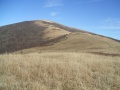
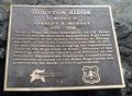
| "The Humps" are quite possibly the greatest balds in the southern Appalachians. At 5587', Hump Mountain stands high above the surrounding hills. It's open meadows can be seen from miles away. One shoulder of Hump Mountain is Houston Ridge where a plaque can be found honoring Stan Murray. | | "The Humps" are quite possibly the greatest balds in the southern Appalachians. At 5587', Hump Mountain stands high above the surrounding hills. It's open meadows can be seen from miles away. One shoulder of Hump Mountain is Houston Ridge where a plaque can be found honoring Stan Murray. |
|
| |
|
| == Doll Flats == | | === Doll Flats === |
|
| |
|
| Primitive camp site on the descent of Hump Mountain before reaching US19E. This is the last point where the Trail touches North Carolina. | | Primitive camp site on the descent of Hump Mountain before reaching US19E. This is the last point where the Trail touches North Carolina. |
|
| |
|
| == US19E - Roan Mountain, TN and Elk Park, NC == | | === US19E - Roan Mountain, TN and Elk Park, NC === |
|
| |
|
| After descending from the Roan Highlands, the Trail reaches US19E (2880'). A few miles west is the town of Roan Mountain, TN where lodging, food and shuttling can be found. To the east is Elk Park, NC where lodging and food can be found. Parking is NOT recommended here. | | After descending from the Roan Highlands, the Trail reaches US19E (2880'). A few miles west is the town of Roan Mountain, TN where lodging, food and shuttling can be found. To the east is Elk Park, NC where lodging and food can be found. Parking is NOT recommended here. |
|
| |
|
| == Photos == | | == Photos == |
| <gallery>
| | {{Park trail gallery|Trail={{PAGENAME}}}} |
| Image:HardcoreMarch.jpg|Hardcore members on the march on the Roan Balds
| |
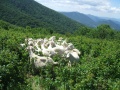
| Image:Goats.jpg|The Baa-tany Project goats on Jane Bald
| |
| Image:GrassyRidgeSplit.jpg|The post at AT & Grassy Ridge Trail split
| |
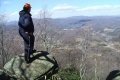
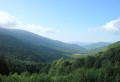
| Image:RoaringForkValley.jpg|View of Roaring Fork Valley from Overmountain Barn Shelter
| |
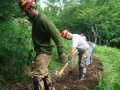
| Image:KonnarockOnLittleHump.jpg|Konnarock Trail Crew working on the Little Hump Relocation
| |
| Image:HumpMtn.jpg|Hump Mountain from Bradley Gap
| |
| Image:HumpMtn2.jpg|View of the Roan Highlands from atop of Hump Mtn
| |
| Image:DollFlatsOverlook.jpg|A hiker at the Doll Flats Overlook
| |
| Image:Plaque on Houston Ridge for Stan Murray.JPG|Plaque on Houston Ridge for Stan Murray
| |
| </gallery>
| |
|
| |
|
| == Maps ==
| |
| <!-- You can place pictures, PDF's, links, or even create a Google map with your waypoints and place it here. -->
| |
| <display_map type="terrain" width="auto" height="600" gkml="http://tehcc.org/clubwiki/kml/Appalachian_Trail_05_Carvers_Gap_to_US19E.kml">
| |
|
| |
| 36.1721300000, -82.011120000~Apple House Campsite~ ~MarkerH.png
| |
| 36.1126711225, -82.028040538~Big Yellow Mountain (5,460 ft)~ ~MarkerP.png
| |
| 36.1273190000, -82.024292000~Campsite~ ~MarkerH.png
| |
| 36.1518710000, -82.010994000~Doll Flats~ ~MarkerH.png
| |
| 36.1504480324, -82.010602467~Doll Flats~ ~MarkerG.png
| |
| 36.1123000000, -82.061400000~Elk Hollow Ridge (5,180 ft)~ ~MarkerP.png
| |
| 36.0960000000, -82.075900000~Grassy Ridge (6,140 ft)~ ~MarkerP.png
| |
| 36.0998000000, -82.080400000~Grassy Ridge Bald (6,180 ft)~ ~MarkerP.png
| |
| 36.1402000000, -82.011900000~Hump Mountain (5,587 ft)~ ~MarkerP.png
| |
| 36.1060000000, -82.093400000~Jane Bald (5,820 ft)~ ~MarkerP.png
| |
| 36.1248000000, -82.028800000~Little Hump Mountain (5,460 ft)~ ~MarkerP.png
| |
| 36.1236150000, -82.054214000~Overmountain Barn~ ~MarkerF.png
| |
| 36.1170074500, -82.048948713~Parking~ ~MarkerA.png
| |
| 36.1063776828, -82.111152795~Parking~ ~MarkerA.png
| |
| 36.1774255669, -82.011786817~Parking~ ~MarkerA.png
| |
| 36.1064640000, -82.111328000~Restrooms~ ~MarkerQ.png
| |
| 36.0932000000, -82.145500000~Roan High Bluff (6,267 ft)~ ~MarkerP.png
| |
| 36.1046000000, -82.122400000~Roan High Knob (6,285 ft)~ ~MarkerP.png
| |
| 36.1070000000, -82.104000000~Round Bald (5,820 ft)~ ~MarkerP.png
| |
| 36.1123620000, -82.065734000~Stan Murray~ ~MarkerF.png
| |
| 36.1396559380, -82.011259441~Stanley Murray Memorial~ ~MarkerG.png
| |
| 36.1393017861, -82.000317779~Stile over fence~ ~MarkerG.png
| |
| 36.1383901555, -82.015412603~Stile over fence~ ~MarkerG.png
| |
| </display_map>
| |
| {{Template:AT_Segments}} | | {{Template:AT_Segments}} |
| | {{Map Marker |
| | |Icon Type=Campground |
| | |Marker Title=Apple House Campsite |
| | |Marker Location=36.1721300000, -82.011120000 |
| | }} |
| | {{Map Marker |
| | |Icon Type=Summit |
| | |Marker Title=Big Yellow Mountain (5,460 ft) |
| | |Marker Location=36.1126711225, -82.028040538 |
| | }} |
| | {{Map Marker |
| | |Icon Type=Campground |
| | |Marker Title=Campsite |
| | |Marker Location=36.1273190000, -82.024292000 |
| | }} |
| | {{Map Marker |
| | |Icon Type=Campground |
| | |Marker Title=Doll Flats |
| | |Marker Location=36.1518710000, -82.010994000 |
| | }} |
| | {{Map Marker |
| | |Icon Type=Point of interest |
| | |Marker Title=Doll Flats |
| | |Marker Location=36.1504480324, -82.010602467 |
| | }} |
| | {{Map Marker |
| | |Icon Type=Summit |
| | |Marker Title=Elk Hollow Ridge (5,180 ft) |
| | |Marker Location=36.1123000000, -82.061400000 |
| | }} |
| | {{Map Marker |
| | |Icon Type=Summit |
| | |Marker Title=Grassy Ridge (6,140 ft) |
| | |Marker Location=36.0960000000, -82.075900000 |
| | }} |
| | {{Map Marker |
| | |Icon Type=Summit |
| | |Marker Title=Grassy Ridge Bald (6,180 ft) |
| | |Marker Location=36.0998000000, -82.080400000 |
| | }} |
| | {{Map Marker |
| | |Icon Type=Summit |
| | |Marker Title=Hump Mountain (5,587 ft) |
| | |Marker Location=36.1402000000, -82.011900000 |
| | }} |
| | {{Map Marker |
| | |Icon Type=Summit |
| | |Marker Title=Jane Bald (5,820 ft) |
| | |Marker Location=36.1060000000, -82.093400000 |
| | }} |
| | {{Map Marker |
| | |Icon Type=Summit |
| | |Marker Title=Little Hump Mountain (5,460 ft) |
| | |Marker Location=36.1248000000, -82.028800000 |
| | }} |
| | {{Map Marker |
| | |Icon Type=Shelter |
| | |Marker Title=Overmountain Barn |
| | |Marker Location=36.1236150000, -82.054214000 |
| | }} |
| | {{Map Marker |
| | |Icon Type=Parking |
| | |Marker Title=Parking |
| | |Marker Location=36.1170074500, -82.048948713 |
| | }} |
| | {{Map Marker |
| | |Icon Type=Parking |
| | |Marker Title=Parking |
| | |Marker Location=36.1063776828, -82.111152795 |
| | }} |
| | {{Map Marker |
| | |Icon Type=Parking |
| | |Marker Title=Parking |
| | |Marker Location=36.1774255669, -82.011786817 |
| | }} |
| | {{Map Marker |
| | |Icon Type=Toilet |
| | |Marker Title=Restrooms |
| | |Marker Location=36.1064640000, -82.111328000 |
| | }} |
| | {{Map Marker |
| | |Icon Type=Summit |
| | |Marker Title=Roan High Bluff (6,267 ft) |
| | |Marker Location=36.0932000000, -82.145500000 |
| | }} |
| | {{Map Marker |
| | |Icon Type=Summit |
| | |Marker Title=Roan High Knob (6,285 ft) |
| | |Marker Location=36.1046000000, -82.122400000 |
| | }} |
| | {{Map Marker |
| | |Icon Type=Summit |
| | |Marker Title=Round Bald (5,820 ft) |
| | |Marker Location=36.1070000000, -82.104000000 |
| | }} |
| | {{Map Marker |
| | |Icon Type=Shelter |
| | |Marker Title=Stan Murray |
| | |Marker Location=36.1123620000, -82.065734000 |
| | }} |
| | {{Map Marker |
| | |Icon Type=Point of interest |
| | |Marker Title=Stanley Murray Memorial |
| | |Marker Location=36.1396559380, -82.011259441 |
| | }} |
| | {{Map Marker |
| | |Icon Type=Point of interest |
| | |Marker Title=Stile over fence |
| | |Marker Location=36.1393017861, -82.000317779 |
| | }} |
| | {{Map Marker |
| | |Icon Type=Point of interest |
| | |Marker Title=Stile over fence |
| | |Marker Location=36.1383901555, -82.015412603 |
| | }} |
| Carver's Gap to US19E
(log in to submit report)
|

|
|
|
| Trail System
|
Appalachian Trail
|
| Land Owner
|
Cherokee National Forest
|
| Located
|
Roan Mountain, Tennessee
|
| Trail Marking
|
White
|
| Trail UseThings allowed to do on or near the trail
|
 
|
| FeaturesThings to see on or near the trail
|
 
|
| Difficulty Rating
|
Medium
|
| Hiking TimeTime from car and back. Includes any time hiking to access this trail.
|
5 hrs0.313 Days <br />300 Min <br /> round trip
|
| Distance:
|
14.8 mi23.818 km <br /> trailStrict non-repeating trail length / 29.6 mi47.636 km <br /> round tripTypical or shortest length from the car, hike the trail, and return to car
|
| Trail Type
|
In-and-Out
|
| Low / High Point
|
2,859 ft953 Yards <br />871.423 Meters <br /> / 5,886 ft1,962 Yards <br />1,794.053 Meters <br />
|
| Elev. Gain/LossSee link for details of calculation. Gain/Loss is direction dependent.
|
2,054 ft626.059 Meters <br /> / (4,703 ft1,433.474 Meters <br />) – South-to-North
|
| Trip ReportsFrom user "hiked it" submissions<br />Recent is within last 90 days
|
1 logged hikes (0 recent)
|
| NearbyWithin 5 mi<br />Click link to view list
|
11 trails / 12.7 mi of trail
|
| Parking
|
36° 6' 22.90" N, 82° 6' 38.02" W Map
|
| Trailhead
|
36° 6' 22.90" N, 82° 6' 38.02" W Map
|
Loading map... {"type":"ROADMAP","minzoom":false,"maxzoom":false,"types":["ROADMAP","SATELLITE","HYBRID","TERRAIN"],"mappingservice":"googlemaps3","width":"100%","height":"180px","centre":false,"title":"","label":"","icon":"","lines":[],"polygons":[],"circles":[],"rectangles":[],"copycoords":false,"static":false,"visitedicon":"","wmsoverlay":false,"zoom":8,"layers":[],"controls":[""],"zoomstyle":"DEFAULT","typestyle":"DEFAULT","autoinfowindows":false,"resizable":false,"kmlrezoom":false,"poi":true,"cluster":false,"clustergridsize":60,"clustermaxzoom":20,"clusterzoomonclick":true,"clusteraveragecenter":true,"clusterminsize":2,"imageoverlays":[],"kml":[],"gkml":[],"searchmarkers":"","fullscreen":false,"scrollwheelzoom":false,"locations":[{"text":"\u003Cb\u003E\u003Cdiv class=\"mw-parser-output\"\u003E\u003Cp\u003ECarver's Gap to US19E\n\u003C/p\u003E\u003C/div\u003E\u003C/b\u003E\u003Cdiv class=\"mw-parser-output\"\u003E\u003Cp\u003EMain Parking Location\n\u003C/p\u003E\u003C/div\u003E","title":"Carver's Gap to US19E\n","link":"","lat":36.10636000000000223053575609810650348663330078125,"lon":-82.1105600000000066529537434689700603485107421875,"icon":""}]} |
| Show In Google Maps
|
Loading map...
{"format":"googlemaps3","type":"TERRAIN","minzoom":false,"maxzoom":false,"types":["SATELLITE","HYBRID","TERRAIN"],"limit":50,"offset":0,"link":"none","sort":[""],"order":[],"headers":"show","mainlabel":"","intro":"","outro":"","searchlabel":"... further results","default":"","import-annotation":false,"width":"auto","height":"600px","centre":false,"title":"","label":"","icon":"","lines":[],"polygons":[],"circles":[],"rectangles":[],"copycoords":false,"static":false,"visitedicon":"","wmsoverlay":false,"zoom":false,"layers":[],"controls":["pan","zoom","type","scale","streetview","rotate"],"zoomstyle":"DEFAULT","typestyle":"DEFAULT","autoinfowindows":false,"resizable":false,"kmlrezoom":true,"poi":true,"cluster":false,"clustergridsize":60,"clustermaxzoom":20,"clusterzoomonclick":true,"clusteraveragecenter":true,"clusterminsize":2,"imageoverlays":[],"kml":[],"gkml":["https://tehcc.org/clubwiki/images/Carver's_Gap_to_US19E.kml"],"searchmarkers":"","fullscreen":false,"scrollwheelzoom":false,"showtitle":false,"hidenamespace":true,"template":"Map Balloon Template","userparam":"","activeicon":"","pagelabel":false,"ajaxcoordproperty":"","ajaxquery":"","locations":[{"text":"\u003Cp\u003E\u003Cb\u003E\u003Ca class=\"mw-selflink selflink\"\u003ECarver's Gap to US19E\u003C/a\u003E\u003C/b\u003E\u003Cbr /\u003E\u003C/p\u003E\u003Chr /\u003E\u003Cp\u003E14.80\u0026#160;Mi (23.82\u0026#160;km)\u003Cbr /\u003EDifficulty: Medium\u003Cbr /\u003EMarking: White\u003C/p\u003E","title":"Carver's Gap to US19E","link":"","lat":36.10636000000000223053575609810650348663330078125,"lon":-82.1105600000000066529537434689700603485107421875,"icon":"/clubwiki/images/MarkerT.png"},{"text":"\u003Cp\u003E\u003Cb\u003ERestrooms\u003C/b\u003E\u003Cbr /\u003E\u003C/p\u003E\u003Chr /\u003E\u003Cp\u003ERestrooms\u003C/p\u003E","title":"Carver's Gap to US19E","link":"","lat":36.1064640000000025565896066837012767791748046875,"lon":-82.1113280000000003155946615152060985565185546875,"icon":"/clubwiki/images/MarkerQ.png"},{"text":"\u003Cp\u003E\u003Cb\u003EHump Mountain (5,587 ft)\u003C/b\u003E\u003Cbr /\u003E\u003C/p\u003E\u003Chr /\u003E\u003Cp\u003EHump Mountain (5,587 ft)\u003C/p\u003E","title":"Carver's Gap to US19E","link":"","lat":36.14020000000000010231815394945442676544189453125,"lon":-82.011899999999997135091689415276050567626953125,"icon":"/clubwiki/images/MarkerP.png"},{"text":"\u003Cp\u003E\u003Cb\u003EElk Hollow Ridge (5,180 ft)\u003C/b\u003E\u003Cbr /\u003E\u003C/p\u003E\u003Chr /\u003E\u003Cp\u003EElk Hollow Ridge (5,180 ft)\u003C/p\u003E","title":"Carver's Gap to US19E","link":"","lat":36.11229999999999762394509161822497844696044921875,"lon":-82.0614000000000061163518694229423999786376953125,"icon":"/clubwiki/images/MarkerP.png"},{"text":"\u003Cp\u003E\u003Cb\u003EStanley Murray Memorial\u003C/b\u003E\u003Cbr /\u003E\u003C/p\u003E\u003Chr /\u003E\u003Cp\u003EStanley Murray Memorial\u003C/p\u003E","title":"Carver's Gap to US19E","link":"","lat":36.13965593799999709290204918943345546722412109375,"lon":-82.0112594410000070865862653590738773345947265625,"icon":"/clubwiki/images/MarkerG.png"},{"text":"\u003Cp\u003E\u003Cb\u003EJane Bald (5,820 ft)\u003C/b\u003E\u003Cbr /\u003E\u003C/p\u003E\u003Chr /\u003E\u003Cp\u003EJane Bald (5,820 ft)\u003C/p\u003E","title":"Carver's Gap to US19E","link":"","lat":36.10600000000000164845914696343243122100830078125,"lon":-82.093400000000002592059900052845478057861328125,"icon":"/clubwiki/images/MarkerP.png"},{"text":"\u003Cp\u003E\u003Cb\u003EOvermountain Barn\u003C/b\u003E\u003Cbr /\u003E\u003C/p\u003E\u003Chr /\u003E\u003Cp\u003EOvermountain Barn\u003C/p\u003E","title":"Carver's Gap to US19E","link":"","lat":36.123615000000000918589648790657520294189453125,"lon":-82.054214000000001760781742632389068603515625,"icon":"/clubwiki/images/MarkerF.png"},{"text":"\u003Cp\u003E\u003Cb\u003ELittle Hump Mountain (5,460 ft)\u003C/b\u003E\u003Cbr /\u003E\u003C/p\u003E\u003Chr /\u003E\u003Cp\u003ELittle Hump Mountain (5,460 ft)\u003C/p\u003E","title":"Carver's Gap to US19E","link":"","lat":36.12480000000000046611603465862572193145751953125,"lon":-82.0288000000000039335645851679146289825439453125,"icon":"/clubwiki/images/MarkerP.png"},{"text":"\u003Cp\u003E\u003Cb\u003EStan Murray\u003C/b\u003E\u003Cbr /\u003E\u003C/p\u003E\u003Chr /\u003E\u003Cp\u003EStan Murray\u003C/p\u003E","title":"Carver's Gap to US19E","link":"","lat":36.11236199999999740839484729804098606109619140625,"lon":-82.0657340000000061763785197399556636810302734375,"icon":"/clubwiki/images/MarkerF.png"},{"text":"\u003Cp\u003E\u003Cb\u003ERoan High Knob (6,285 ft)\u003C/b\u003E\u003Cbr /\u003E\u003C/p\u003E\u003Chr /\u003E\u003Cp\u003ERoan High Knob (6,285 ft)\u003C/p\u003E","title":"Carver's Gap to US19E","link":"","lat":36.10459999999999780584403197281062602996826171875,"lon":-82.122399999999998954081092961132526397705078125,"icon":"/clubwiki/images/MarkerP.png"},{"text":"\u003Cp\u003E\u003Cb\u003ECampsite\u003C/b\u003E\u003Cbr /\u003E\u003C/p\u003E\u003Chr /\u003E\u003Cp\u003ECampsite\u003C/p\u003E","title":"Carver's Gap to US19E","link":"","lat":36.12731899999999995998223312199115753173828125,"lon":-82.02429200000000264481059275567531585693359375,"icon":"/clubwiki/images/MarkerH.png"},{"text":"\u003Cp\u003E\u003Cb\u003EDoll Flats\u003C/b\u003E\u003Cbr /\u003E\u003C/p\u003E\u003Chr /\u003E\u003Cp\u003EDoll Flats\u003C/p\u003E","title":"Carver's Gap to US19E","link":"","lat":36.15044803239999993138553691096603870391845703125,"lon":-82.0106024669999982279477990232408046722412109375,"icon":"/clubwiki/images/MarkerG.png"},{"text":"\u003Cp\u003E\u003Cb\u003EStile over fence\u003C/b\u003E\u003Cbr /\u003E\u003C/p\u003E\u003Chr /\u003E\u003Cp\u003EStile over fence\u003C/p\u003E","title":"Carver's Gap to US19E","link":"","lat":36.13839015549999800214209244586527347564697265625,"lon":-82.0154126030000014679899322800338268280029296875,"icon":"/clubwiki/images/MarkerG.png"},{"text":"\u003Cp\u003E\u003Cb\u003ERound Bald (5,820 ft)\u003C/b\u003E\u003Cbr /\u003E\u003C/p\u003E\u003Chr /\u003E\u003Cp\u003ERound Bald (5,820 ft)\u003C/p\u003E","title":"Carver's Gap to US19E","link":"","lat":36.106999999999999317878973670303821563720703125,"lon":-82.1039999999999992041921359486877918243408203125,"icon":"/clubwiki/images/MarkerP.png"},{"text":"\u003Cp\u003E\u003Cb\u003EApple House Campsite\u003C/b\u003E\u003Cbr /\u003E\u003C/p\u003E\u003Chr /\u003E\u003Cp\u003EApple House Campsite\u003C/p\u003E","title":"Carver's Gap to US19E","link":"","lat":36.17213000000000278078005067072808742523193359375,"lon":-82.0111200000000053478288464248180389404296875,"icon":"/clubwiki/images/MarkerH.png"},{"text":"\u003Cp\u003E\u003Cb\u003EGrassy Ridge (6,140 ft)\u003C/b\u003E\u003Cbr /\u003E\u003C/p\u003E\u003Chr /\u003E\u003Cp\u003EGrassy Ridge (6,140 ft)\u003C/p\u003E","title":"Carver's Gap to US19E","link":"","lat":36.09599999999999653255144949071109294891357421875,"lon":-82.0759000000000042973624658770859241485595703125,"icon":"/clubwiki/images/MarkerP.png"},{"text":"\u003Cp\u003E\u003Cb\u003EParking\u003C/b\u003E\u003Cbr /\u003E\u003C/p\u003E\u003Chr /\u003E\u003Cp\u003EParking\u003C/p\u003E","title":"Carver's Gap to US19E","link":"","lat":36.106377682800001593932393006980419158935546875,"lon":-82.1111527949999953079895931296050548553466796875,"icon":"/clubwiki/images/MarkerA.png"},{"text":"\u003Cp\u003E\u003Cb\u003ERoan High Bluff (6,267 ft)\u003C/b\u003E\u003Cbr /\u003E\u003C/p\u003E\u003Chr /\u003E\u003Cp\u003ERoan High Bluff (6,267 ft)\u003C/p\u003E","title":"Carver's Gap to US19E","link":"","lat":36.09320000000000305817593471147119998931884765625,"lon":-82.145499999999998408384271897375583648681640625,"icon":"/clubwiki/images/MarkerP.png"},{"text":"\u003Cp\u003E\u003Cb\u003EGrassy Ridge Bald (6,180 ft)\u003C/b\u003E\u003Cbr /\u003E\u003C/p\u003E\u003Chr /\u003E\u003Cp\u003EGrassy Ridge Bald (6,180 ft)\u003C/p\u003E","title":"Carver's Gap to US19E","link":"","lat":36.0998000000000018872015061788260936737060546875,"lon":-82.08039999999999736246536485850811004638671875,"icon":"/clubwiki/images/MarkerP.png"},{"text":"\u003Cp\u003E\u003Cb\u003EParking\u003C/b\u003E\u003Cbr /\u003E\u003C/p\u003E\u003Chr /\u003E\u003Cp\u003EParking\u003C/p\u003E","title":"Carver's Gap to US19E","link":"","lat":36.1774255668999984436595696024596691131591796875,"lon":-82.011786817000000837651896290481090545654296875,"icon":"/clubwiki/images/MarkerA.png"},{"text":"\u003Cp\u003E\u003Cb\u003EStile over fence\u003C/b\u003E\u003Cbr /\u003E\u003C/p\u003E\u003Chr /\u003E\u003Cp\u003EStile over fence\u003C/p\u003E","title":"Carver's Gap to US19E","link":"","lat":36.13930178609999899208560236729681491851806640625,"lon":-82.00031777899999951841891743242740631103515625,"icon":"/clubwiki/images/MarkerG.png"},{"text":"\u003Cp\u003E\u003Cb\u003EBig Yellow Mountain (5,460 ft)\u003C/b\u003E\u003Cbr /\u003E\u003C/p\u003E\u003Chr /\u003E\u003Cp\u003EBig Yellow Mountain (5,460 ft)\u003C/p\u003E","title":"Carver's Gap to US19E","link":"","lat":36.11267112249999655659848940558731555938720703125,"lon":-82.028040537999999060048139654099941253662109375,"icon":"/clubwiki/images/MarkerP.png"},{"text":"\u003Cp\u003E\u003Cb\u003EDoll Flats\u003C/b\u003E\u003Cbr /\u003E\u003C/p\u003E\u003Chr /\u003E\u003Cp\u003EDoll Flats\u003C/p\u003E","title":"Carver's Gap to US19E","link":"","lat":36.151870999999999867213773541152477264404296875,"lon":-82.0109939999999966175892041064798831939697265625,"icon":"/clubwiki/images/MarkerH.png"},{"text":"\u003Cp\u003E\u003Cb\u003EParking\u003C/b\u003E\u003Cbr /\u003E\u003C/p\u003E\u003Chr /\u003E\u003Cp\u003EParking\u003C/p\u003E","title":"Carver's Gap to US19E","link":"","lat":36.1170074500000026773705030791461467742919921875,"lon":-82.0489487130000014758479665033519268035888671875,"icon":"/clubwiki/images/MarkerA.png"}]}
Download KML / Upload new version / KML File Page / Create Profile Chart / gpsvisualizer Map
Trail Overview[edit]
How to get there[edit]
Route Description[edit]
(Trail South > North)
Carvers Gap[edit]
Carvers Gap (5512') is the primary road access for the Roan Highlands. TN143 comes from Roan Mountain, TN and NC261 comes from Bakersville, NC. Large parking area with restrooms. The road to the top of Roan Mountain is open from approximately May-October.
Round Bald[edit]
Round Bald (5826') is one of the many famous balds of the Roan Highlands. Round Bald has 360 degree views from its summit. Round Bald is also home to one of the TEHCC's greatest trail maintenance projects - hardened gravel and geotextile over 1 mile of the Trail. This project was completed in 2001.
Jane Bald[edit]
Jane Bald (5807') is another Roan Highlands bald. It's name is derived from Jane Cook whose sister Harriet died of milk sickness on the bald in November of 1870.
Grassy Ridge Side Trail[edit]
The Grassy Ridge side trail leads 0.5 miles to the summit. A plaque, located at the summit, is dedicated to Cornelius Rex Peake who owned and donated much of the mountain. The Grassy Ridge summit is a part of the South Beyond 6000 Challenge.
Shelter[edit]
Overmountain Victory Trail[edit]
The Overmountain Victory Trail crosses the AT at Yellow Mountain Gap and offers an alternate from Roaring Creek Valley. This is a part of the original 330 mile route used by the Revolutionary War frontiersmen that traveled from Abingdon, VA to Kings Mountain, NC/SC where they defeated the Loyalists. The route officially starts as a walking trail at Hampton Creek Cove State Natural Area outside of Roan Mountain, TN and connects to Roaring Creek, NC. OVTA members can be seen walking this route in the Fall in remembrance of the 1780 march.
Little Hump Mountain and Hump Mountain[edit]
"The Humps" are quite possibly the greatest balds in the southern Appalachians. At 5587', Hump Mountain stands high above the surrounding hills. It's open meadows can be seen from miles away. One shoulder of Hump Mountain is Houston Ridge where a plaque can be found honoring Stan Murray.
Doll Flats[edit]
Primitive camp site on the descent of Hump Mountain before reaching US19E. This is the last point where the Trail touches North Carolina.
US19E - Roan Mountain, TN and Elk Park, NC[edit]
After descending from the Roan Highlands, the Trail reaches US19E (2880'). A few miles west is the town of Roan Mountain, TN where lodging, food and shuttling can be found. To the east is Elk Park, NC where lodging and food can be found. Parking is NOT recommended here.
A hiker at the Doll Flats Overlook
The Baa-tany Project goats on Jane Bald
The post at AT & Grassy Ridge Trail split
Hardcore members on the march on the Roan Balds
Hump Mountain from Bradley Gap
View of the Roan Highlands from atop of Hump Mtn
Konnarock Trail Crew working on the Little Hump Relocation
Plaque on Houston Ridge for Stan Murray
View of Roaring Fork Valley from Overmountain Barn Shelter