|
|
|
|
|
| Trail Name
|
Grassy Ridge
|
| Nearest City
|
Roan Mountain
|
| State
|
Tennessee
|
| Trail Marking
|
White blaze
|
| Trail Use/Features
|
 
|
| Difficulty Rating
|
Easy
|
| Hiking Time
|
44 Hours <br />0.25 Days <br />240 Min <br />
|
| Distance, round-trip
|
44 mi <br />6.437 km <br />
|
| Climb/Descent Elevation
|
650650 Feet <br />198.12 Meters <br /> / {{{Elevation Loss}}}"{{{Elevation Loss}}}" is not a number.
|
| High Point
|
6,1606,160 Feet <br />2,053.333 Yards <br />1,877.568 Meters <br />
|
| Nearest Medical
|
Elizabethton, TN
|
| Trip Reports
|
Click Here
|
|
|
Loading map... {"type":"ROADMAP","minzoom":false,"maxzoom":false,"types":["ROADMAP","SATELLITE","HYBRID","TERRAIN"],"mappingservice":"googlemaps3","width":"270px","height":"180px","centre":false,"title":"","label":"","icon":"","lines":[],"polygons":[],"circles":[],"rectangles":[],"copycoords":false,"static":false,"visitedicon":"","wmsoverlay":false,"zoom":8,"layers":[],"controls":["zoom"],"zoomstyle":"DEFAULT","typestyle":"DEFAULT","autoinfowindows":false,"resizable":false,"kmlrezoom":false,"poi":true,"cluster":false,"clustergridsize":60,"clustermaxzoom":20,"clusterzoomonclick":true,"clusteraveragecenter":true,"clusterminsize":2,"imageoverlays":[],"kml":[],"gkml":[],"searchmarkers":"","fullscreen":false,"scrollwheelzoom":false,"locations":[{"text":"","title":"","link":"","lat":36.1062500000000028421709430404007434844970703125,"lon":-82.110183000000006359186954796314239501953125,"icon":""}]} |
|
| Show Large Map
|
|
Trail Overview[edit]
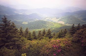
Spur trail off AT above Carver's Gap. Hike across balds by Catawba rhododendron (late June to September), pick huckleberries (August to mid-September), see the goats (July thru September), and reach the natural 360˚ view on the summit.
How to get there[edit]
From Kingsport, TN
- Take I-26 south to Exit 24 for US-321/TN-67 toward Elizabethton.
- Continue through Elizabethton and right at traffic light to stay on US-321 South.
- At Hampton, stay on US19E as it veers right.
- At Roan Mountain, turn right (south) onto TN143.
- Travel 13 miles to the TN/NC border and park at Carver's Gap.
(Alternatively at Steps 2-3, once just inside Elizabethton city limits, turn right on TN-362, then right again and follow Gap Creek Rd for 8 miles to US19E, thus bypassing around Elizabethton and Hampton.)
Route Description[edit]
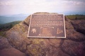
From Carver's Gap, take AT northbound up and over the balds. (Stay on the trail path!) At roughly two miles along the AT, a junction sign will show the spur trail up to Grassy Ridge, which climbs up an established rut (which can become a creek in the rain). Reach the rock outcropping at the summit. Read the dedication plaque to Cornelious Rex Peake. Have lunch. And then return by reverse route.
For family, hiking just to Round or Jane Bald will be sufficient - and avoids the rougher trail path heading up to Grassy Ridge.
Typical Conditions[edit]
From the trailhead, follow path which has been specifically routed and hardened using gravel on geotextile. Stay on this route to avoid damage to the fragile landscape. Accessible year-around, thus can be snow covered trail in winter to summer rainshowers. High enough elevation to sometimes be "up in the clouds" as mist passes up and over the gap. The temperature up on the balds can be 10-15F lower than down in the valley, so bringing a light jacket is a good idea - even if you don't need it when you leave town.
Fees, Permits, etc.[edit]
No permits or fees.
After the Hike[edit]
Grab a drink and/or a cone in Elizabethton on the way back.
Misc. Information[edit]
Grassy Ridge is one of the South Beyond 6000 peaks.
Loading map...
{"type":"TERRAIN","minzoom":false,"maxzoom":false,"types":["ROADMAP","SATELLITE","HYBRID","TERRAIN"],"mappingservice":"googlemaps3","width":"90%","height":"600px","centre":false,"title":"","label":"","icon":"","lines":[],"polygons":[],"circles":[],"rectangles":[],"copycoords":false,"static":false,"visitedicon":"","wmsoverlay":false,"zoom":false,"layers":[],"controls":["pan","zoom","type","scale","streetview","rotate"],"zoomstyle":"DEFAULT","typestyle":"DEFAULT","autoinfowindows":false,"resizable":false,"kmlrezoom":false,"poi":true,"cluster":false,"clustergridsize":60,"clustermaxzoom":20,"clusterzoomonclick":true,"clusteraveragecenter":true,"clusterminsize":2,"imageoverlays":[],"kml":[],"gkml":["https://tehcc.org/clubwiki/kml/Grassy_Ridge.kml"],"searchmarkers":"","fullscreen":false,"scrollwheelzoom":false,"locations":[{"text":"\u003Cdiv class=\"mw-parser-output\"\u003E\u003Cp\u003EParking at Carver's Gap\n\u003C/p\u003E\u003C/div\u003E","title":"Parking at Carver's Gap\n","link":"","lat":36.1062500000000028421709430404007434844970703125,"lon":-82.110183000000006359186954796314239501953125,"icon":"/clubwiki/images/MarkerA.png"},{"text":"\u003Cdiv class=\"mw-parser-output\"\u003E\u003Cp\u003ERound Bald (5826')\n\u003C/p\u003E\u003C/div\u003E","title":"Round Bald (5826')\n","link":"","lat":36.106819999999999026840669102966785430908203125,"lon":-82.1036830000000037443896871991455554962158203125,"icon":"/clubwiki/images/MarkerE.png"},{"text":"\u003Cdiv class=\"mw-parser-output\"\u003E\u003Cp\u003EJane Bald (5807')\n\u003C/p\u003E\u003C/div\u003E","title":"Jane Bald (5807')\n","link":"","lat":36.10593000000000074578565545380115509033203125,"lon":-82.0933830000000028803697205148637294769287109375,"icon":"/clubwiki/images/MarkerE.png"},{"text":"\u003Cdiv class=\"mw-parser-output\"\u003E\u003Cp\u003ESpur trail to Grassy Ridge\n\u003C/p\u003E\u003C/div\u003E","title":"Spur trail to Grassy Ridge\n","link":"","lat":36.10548000000000001818989403545856475830078125,"lon":-82.0853670000000050777089199982583522796630859375,"icon":"/clubwiki/images/MarkerG.png"},{"text":"\u003Cdiv class=\"mw-parser-output\"\u003E\u003Cp\u003EGrassy Ridge\n\u003C/p\u003E\u003C/div\u003E","title":"Grassy Ridge\n","link":"","lat":36.1000999999999976353137753903865814208984375,"lon":-82.080883000000000038198777474462985992431640625,"icon":"/clubwiki/images/MarkerE.png"}]}
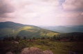
View back the way you came
Plaque dedicated to Cornelious Rex Peake
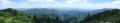
Panorama of the southern end of Grassy Ridge