Twin Pinnacles Trail: Difference between revisions
m (→Route Description: Fixed typo) |
m (Tim moved page Twin Pinnacles to Twin Pinnacles Trail without leaving a redirect: Consistent naming) |
||
| (7 intermediate revisions by 2 users not shown) | |||
| Line 1: | Line 1: | ||
<!-- The following few lines create the "Infobox" table template. Please scroll down to edit the main content of the article. | <!-- The following few lines create the "Infobox" table template. Please scroll down to edit the main content of the article. | ||
-->{{Infobox Trail | |||
| Image Name = Grayson_Highlands_SP_-_Little_Pinnacle.jpg | |||
| Park = Grayson Highlands State Park | |||
| City = Mouth of Wilson | |||
| State = Virginia | |||
| Marking = Red Blaze | |||
| Trail Use = {{Dogs}} {{Hike}} | |||
| Difficulty Rating = Easy | |||
| Hike Time = 1.5 Hours | |||
| Round Trip Distance = 1.6 Mi | |||
| Trail Distance = 1.6 Mi | |||
| Trail Type = In-and-Out | |||
| Elevation Gain = 100 Ft | |||
| Elevation Loss = -100 Ft | |||
| High Point = 5,089 Ft | |||
| Parking coords = 36.628479,-81.496582 | |||
| Trailhead coords = 36.628479,-81.496582 | |||
| Medical = Damascus | |||
}}<!-- | |||
End Infobox template table | |||
-->{{Trail page needs | |||
| Hide needs = | |||
| KML = Yes | |||
| Updated KML = | |||
| Detail route description = Yes | |||
| Photos = Yes | |||
| Winter photos = | |||
| Remove prefix = | |||
| Update infobox = | |||
| Infobox data update = Yes | |||
| Trail pins = | |||
| Other = | |||
| Comment = | |||
| Date reviewed = 1/2/2016 | |||
}}<!-- | |||
Start of Main Page --> | |||
== Trail Overview == | == Trail Overview == | ||
<!-- Enter a overview of the trail. What attracts you to this trail, points of interest, types of flowers, lakes, and peaks that you see along the way. --> | <!-- Enter a overview of the trail. What attracts you to this trail, points of interest, types of flowers, lakes, and peaks that you see along the way. --> | ||
| Line 27: | Line 48: | ||
Driving direction are given on the [[Grayson Highlands State Park]] page. | Driving direction are given on the [[Grayson Highlands State Park]] page. | ||
Trailhead is behind the visitors' center. Start at bright orange marker to begin following red blazed trail. | Trailhead is behind the visitors' center. Start at bright orange marker to begin following the red blazed trail. | ||
Alternatively, park at Massie Gap and take the 0.4 mile Big Pinnacle Trail up the mountain. Once at Twin Pinnacles Trail, head right for Big Pinnacle or left for Little Pinnacle. | Alternatively, park at Massie Gap and take the 0.4 mile Big Pinnacle Trail up the mountain. Once at Twin Pinnacles Trail, head right for Big Pinnacle or left for Little Pinnacle. | ||
| Line 43: | Line 64: | ||
==Fees, Permits, etc. == | ==Fees, Permits, etc. == | ||
<!-- Please list any Fees, Permits, Regulations, etc. that may be required on this trail.--> | <!-- Please list any Fees, Permits, Regulations, etc. that may be required on this trail.--> | ||
Daily parking fee for passenger vehicles | Daily parking fee for passenger vehicles (as of 2018) is now $5 for Virginia tags, $7 out-of-state. | ||
== After the Hike == | == After the Hike == | ||
| Line 55: | Line 76: | ||
== Maps == | == Maps == | ||
<!-- You can place pictures, PDF's, links, or even create a Google map with your waypoints and place it here. --> | <!-- You can place pictures, PDF's, links, or even create a Google map with your waypoints and place it here. --> | ||
< | <display_map center="36.63002,-81.50955" type="terrain" zoom="14" width="auto" height="550"> | ||
36.6248, -81.50103~Trailhead behind visitors' center~ ~MarkerT.png | |||
Trailhead behind visitors' center | 36.6267, -81.5041~Temporary storm shelter~ ~MarkerF.png | ||
36.63002,-81.50955~Big Pinnacle (5,068 feet)~ ~MarkerE.png | |||
Temporary storm shelter | 36.62678,-81.50507~Little Pinnacle (5,089 feet)~ ~MarkerE.png | ||
36.62778,-81.50347~Temporary storm shelter~ ~MarkerF.png | |||
Big Pinnacle (5,068 feet) | 36.63332,-81.50903~Massie Gap Parking~ ~MarkerA.png | ||
</display_map> | |||
Little Pinnacle (5,089 feet) | |||
Temporary storm shelter | |||
</ | |||
== Photos == | == Photos == | ||
<gallery> | <gallery> | ||
<!-- Place any pictures from this trail below. Ideally we would have a picture of the trailhead to help people know when they found it --> | <!-- Place any pictures from this trail below. Ideally we would have a picture of the trailhead to help people know when they found it --> | ||
Image:GHSP View from Big Pinnacle.jpg|View from Big Pinnacle | |||
<!-- Do not remove the end gallery code.--> | <!-- Do not remove the end gallery code.--> | ||
</gallery> | </gallery> | ||
Latest revision as of 08:03, 29 August 2020
| |||||||||||||||||||||||||||||||||||||||||||||

Trail Overview[edit]
This popular park route bags its two highest peaks of Little Pinnacle (5,089 feet) and Big Pinnacle (5,068 feet).
How to get there[edit]
Driving direction are given on the Grayson Highlands State Park page.
Trailhead is behind the visitors' center. Start at bright orange marker to begin following the red blazed trail.
Alternatively, park at Massie Gap and take the 0.4 mile Big Pinnacle Trail up the mountain. Once at Twin Pinnacles Trail, head right for Big Pinnacle or left for Little Pinnacle.
Route Description[edit]
From the visitors' center, the hike begin walking through the forest until a large map sign is reached. At that point the loop can be taken either left towards Little Pinnacle or right towards Big Pinnacle. The path is through thickets of mountain laurel and rhododendron plus a favorite of many: huckleberries, which are like small blueberries (ripe in August to early September). The climb to top of Big Pinnacle is steep, but great place for lunch to look out over the valley. (Warning: Dangerous, sharp drop-off!) Part of the trail also proceeds through scrub forest with ferns.
Typical Conditions[edit]
Well established trail with some switchbacks through rocky outcroppings.
There are several covered 3-4 person shelters along the trail to provide some protection against sudden storms which can blow over the mountain.
Fees, Permits, etc.[edit]
Daily parking fee for passenger vehicles (as of 2018) is now $5 for Virginia tags, $7 out-of-state.
After the Hike[edit]
Misc. Information[edit]
Maps[edit]
Photos[edit]
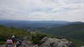
View from Big Pinnacle
