This popular park route bags its two highest peaks of Little Pinnacle (5,089 feet) and Big Pinnacle (5,068 feet).
Trailhead is behind the visitors' center. Start at bright orange marker to begin following the red blazed trail.
Alternatively, park at Massie Gap and take the 0.4 mile Big Pinnacle Trail up the mountain. Once at Twin Pinnacles Trail, head right for Big Pinnacle or left for Little Pinnacle.
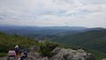
From the visitors' center, the hike begin walking through the forest until a large map sign is reached. At that point the loop can be taken either left towards Little Pinnacle or right towards Big Pinnacle. The path is through thickets of mountain laurel and rhododendron plus a favorite of many: huckleberries, which are like small blueberries (ripe in August to early September). The climb to top of Big Pinnacle is steep, but great place for lunch to look out over the valley. (Warning: Dangerous, sharp drop-off!) Part of the trail also proceeds through scrub forest with ferns.
Well established trail with some switchbacks through rocky outcroppings.
There are several covered 3-4 person shelters along the trail to provide some protection against sudden storms which can blow over the mountain.
Daily parking fee for passenger vehicles (as of 2018) is now $5 for Virginia tags, $7 out-of-state.
Loading map...
{"type":"TERRAIN","minzoom":false,"maxzoom":false,"types":["ROADMAP","SATELLITE","HYBRID","TERRAIN"],"mappingservice":"googlemaps3","width":"auto","height":"550px","centre":{"text":"","title":"","link":"","lat":36.63002000000000180079950951039791107177734375,"lon":-81.5095500000000043883119360543787479400634765625,"icon":""},"title":"","label":"","icon":"","lines":[],"polygons":[],"circles":[],"rectangles":[],"copycoords":false,"static":false,"visitedicon":"","wmsoverlay":false,"zoom":14,"layers":[],"controls":["pan","zoom","type","scale","streetview","rotate"],"zoomstyle":"DEFAULT","typestyle":"DEFAULT","autoinfowindows":false,"resizable":false,"kmlrezoom":false,"poi":true,"cluster":false,"clustergridsize":60,"clustermaxzoom":20,"clusterzoomonclick":true,"clusteraveragecenter":true,"clusterminsize":2,"imageoverlays":[],"kml":[],"gkml":[],"searchmarkers":"","fullscreen":false,"scrollwheelzoom":false,"locations":[{"text":"\u003Cdiv class=\"mw-parser-output\"\u003E\u003Cp\u003ETrailhead behind visitors' center\n\u003C/p\u003E\u003C/div\u003E","title":"Trailhead behind visitors' center\n","link":"","lat":36.62480000000000046611603465862572193145751953125,"lon":-81.5010300000000000864019966684281826019287109375,"icon":"/clubwiki/images/MarkerT.png"},{"text":"\u003Cdiv class=\"mw-parser-output\"\u003E\u003Cp\u003ETemporary storm shelter\n\u003C/p\u003E\u003C/div\u003E","title":"Temporary storm shelter\n","link":"","lat":36.626699999999999590727384202182292938232421875,"lon":-81.5040999999999939973349682986736297607421875,"icon":"/clubwiki/images/MarkerF.png"},{"text":"\u003Cdiv class=\"mw-parser-output\"\u003E\u003Cp\u003EBig Pinnacle (5,068 feet)\n\u003C/p\u003E\u003C/div\u003E","title":"Big Pinnacle (5,068 feet)\n","link":"","lat":36.63002000000000180079950951039791107177734375,"lon":-81.5095500000000043883119360543787479400634765625,"icon":"/clubwiki/images/MarkerE.png"},{"text":"\u003Cdiv class=\"mw-parser-output\"\u003E\u003Cp\u003ELittle Pinnacle (5,089 feet)\n\u003C/p\u003E\u003C/div\u003E","title":"Little Pinnacle (5,089 feet)\n","link":"","lat":36.62677999999999656211002729833126068115234375,"lon":-81.5050700000000034606273402459919452667236328125,"icon":"/clubwiki/images/MarkerE.png"},{"text":"\u003Cdiv class=\"mw-parser-output\"\u003E\u003Cp\u003ETemporary storm shelter\n\u003C/p\u003E\u003C/div\u003E","title":"Temporary storm shelter\n","link":"","lat":36.627780000000001336957211606204509735107421875,"lon":-81.5034699999999929787009023129940032958984375,"icon":"/clubwiki/images/MarkerF.png"},{"text":"\u003Cdiv class=\"mw-parser-output\"\u003E\u003Cp\u003EMassie Gap Parking\n\u003C/p\u003E\u003C/div\u003E","title":"Massie Gap Parking\n","link":"","lat":36.633319999999997662598616443574428558349609375,"lon":-81.50902999999999565261532552540302276611328125,"icon":"/clubwiki/images/MarkerA.png"}]}