Turkey Trot: Difference between revisions
(Update IB to new format) |
No edit summary |
||
| (7 intermediate revisions by 2 users not shown) | |||
| Line 1: | Line 1: | ||
{{Trail | |||
{{ | |Banner Image=File:Roan Forest Road and Turkey Trot.jpg | ||
|Trail Highlight=Connects the cabins to the trail artery Forest Road | |||
|Park=Roan Mountain State Park | |||
|Trail Marking=Red | |||
|Trail Use=Hiking | |||
|Difficulty Rating=Medium | |||
|Hike Time=20 min | |||
|Trail Distance=0.4090 mi | |||
|Round Trip Distance=0.8 mi | |||
|Trail Type=Segment | |||
|High Point=3,090 ft | |||
|Low Point=2,887 ft | |||
|Elevation Gain=200 ft | |||
|Elevation Loss=0 ft | |||
|Elevation Change Direction=South-to-North | |||
|Parking location=36.16735, -82.09421 | |||
|Trailhead location=36.16735, -82.09421 | |||
}} | }} | ||
{{Trail Map|Other Trails=Forest Road}} | |||
__TOC__ | |||
== Trail Overview == | == Trail Overview == | ||
This is part of the [[Roan Mountain State Park]] trail system and can be used as part of a circuit from the campground or the cabins using one of the many access trails along this and [[Forest Road|Forest Road Trail]]. | |||
This is part of the [[Roan Mountain State Park]] trail system | |||
== How to get there == | == How to get there == | ||
| Line 35: | Line 35: | ||
== Route Description== | == Route Description== | ||
[[File:Turkey trot profile.png|thumb|right]]A spur off of [[Trail connects to::Forest Road|Forest Road Trail]]. Likely use is for cabin renters to get to the Forest Road Trail to for options of making it to the Visitor's Center, [[Raven Rock]], or for the really adventurous the [[Chestnut Ridge|Miller Homestead]]. | |||
A spur off of [[Trail connects to::Forest Road|Forest Road Trail]]. | |||
== Typical Conditions == | == Typical Conditions == | ||
<!-- Typical conditions throughout the year of what to expect on the trail. Rocky, muddy, sandy, flowers, lots of downed trees? --> | <!-- Typical conditions throughout the year of what to expect on the trail. Rocky, muddy, sandy, flowers, lots of downed trees? --> | ||
Being a TN state park, the dirt and gravel trails are kept in good condition. Some of the trail sections are steep, thus can be slippery after a rain. | Being a TN state park, the dirt and gravel trails are kept in good condition. Some of the trail sections are steep, thus can be slippery after a rain. | ||
== Photos == | == Photos == | ||
{{Park trail gallery|Trail={{PAGENAME}}}} | |||
{{Map Marker | |||
|Icon Type=Trail sign | |||
Image: | |Marker Title=Intersection with Forest Road Trail | ||
|Marker Description=[[Image:Roan Forest Road and Turkey Trot.jpg|150px|Intersection of Forest Road and Turkey Trot Trails]] | |||
|Marker Location=36.169924,-82.092525 | |||
}} | |||
{{Map Marker | |||
[[ | |Icon Type=Trail sign | ||
|Marker Title=Unknown trail intersection | |||
|Marker Description=[[Image:Roan Turkey Trot sign.jpg|150px|mid-trail sign]] | |||
|Marker Location=36.168618,-82.095173 | |||
}} | |||
{{Map Marker | |||
|Icon Type=Point of interest | |||
|Marker Title=Trail terminus at cabins | |||
|Marker Location=36.167352,-82.094209 | |||
}} | |||
Latest revision as of 23:05, 4 January 2020
| Turkey Trot (log in to submit report) | |
|---|---|

| |
| Highlight | Connects the cabins to the trail artery Forest Road |
| Park | Roan Mountain State Park |
| Located | Roan Mountain, TennesseeLocation inherited from associated park |
| Trail Marking | Red |
| Trail UseThings allowed to do on or near the trail |
|
| FeaturesThings to see on or near the trail |
|
| Difficulty Rating | Medium |
| Hiking TimeTime from car and back. Includes any time hiking to access this trail. | 20 min0.333 Hours <br />0.0208 Days <br /> round trip |
| Distance: | 0.4090 mi0.658 km <br /> trailStrict non-repeating trail length / 0.8 mi1.287 km <br /> round tripTypical or shortest length from the car, hike the trail, and return to car |
| Trail Type | Segment |
| Low / High Point | 2,887 ft962.333 Yards <br />879.958 Meters <br /> / 3,090 ft1,030 Yards <br />941.832 Meters <br /> |
| Elev. Gain/LossSee link for details of calculation. Gain/Loss is direction dependent. | 200 ft60.96 Meters <br /> / (0 ft0 Meters <br />) – South-to-North |
| Trip ReportsFrom user "hiked it" submissions<br />Recent is within last 90 days | No hikes logged yet |
| NearbyWithin 5 mi<br />Click link to view list | 12 trails / 50.2 mi of trail |
| Parking | 36° 10' 2.46" N, 82° 5' 39.16" W Map |
| Trailhead | 36° 10' 2.46" N, 82° 5' 39.16" W Map |
|
| |
| Show In Google Maps | |
Download KML / Upload new version / KML File Page / Create Profile Chart / gpsvisualizer Map
Trail Overview[edit]
This is part of the Roan Mountain State Park trail system and can be used as part of a circuit from the campground or the cabins using one of the many access trails along this and Forest Road Trail.
How to get there[edit]
From Johnson City (I-26 Exit 24):
- Take TN67/US321 over to Elizabethton (about eight miles).
- Turn right/south at traffic light for TN37/US19E/US321 and travel for 17 miles.
- Turn right/south for TN143 for five miles to park visitors center.
- Trailheads are in several places around the park.
GPS address is 1015 Hwy 143 Roan Mountain, TN 37687.
Route Description[edit]

A spur off of Forest Road Trail. Likely use is for cabin renters to get to the Forest Road Trail to for options of making it to the Visitor's Center, Raven Rock, or for the really adventurous the Miller Homestead.
Typical Conditions[edit]
Being a TN state park, the dirt and gravel trails are kept in good condition. Some of the trail sections are steep, thus can be slippery after a rain.
Photos[edit]
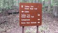
Intersection of Forest Road and Turkey Trot Trails
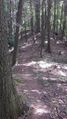
View of the trail
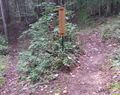
Trail intersection

Trail Profile

