Loading map...
{"format":"googlemaps3","type":"TERRAIN","minzoom":false,"maxzoom":false,"types":["SATELLITE","HYBRID","TERRAIN"],"limit":50,"offset":0,"link":"none","sort":[""],"order":[],"headers":"show","mainlabel":"","intro":"","outro":"","searchlabel":"... further results","default":"","import-annotation":false,"width":"auto","height":"600px","centre":false,"title":"","label":"","icon":"","lines":[],"polygons":[],"circles":[],"rectangles":[],"copycoords":false,"static":false,"visitedicon":"","wmsoverlay":false,"zoom":false,"layers":[],"controls":["pan","zoom","type","scale","streetview","rotate"],"zoomstyle":"DEFAULT","typestyle":"DEFAULT","autoinfowindows":false,"resizable":false,"kmlrezoom":true,"poi":true,"cluster":false,"clustergridsize":60,"clustermaxzoom":20,"clusterzoomonclick":true,"clusteraveragecenter":true,"clusterminsize":2,"imageoverlays":[],"kml":[],"gkml":["https://tehcc.org/clubwiki/images/Chestnut_Ridge.kml","https://tehcc.org/clubwiki/images/Forest_Road.kml"],"searchmarkers":"","fullscreen":false,"scrollwheelzoom":false,"showtitle":false,"hidenamespace":true,"template":"Map Balloon Template","userparam":"","activeicon":"","pagelabel":false,"ajaxcoordproperty":"","ajaxquery":"","locations":[{"text":"\u003Cp\u003E\u003Cb\u003E\u003Ca class=\"mw-selflink selflink\"\u003EChestnut Ridge\u003C/a\u003E\u003C/b\u003E\u003Cbr /\u003E\u003C/p\u003E\u003Chr /\u003E\u003Cp\u003E2.19\u0026#160;Mi (3.53\u0026#160;km)\u003Cbr /\u003EDifficulty: Medium\u003Cbr /\u003EMarking: Orange\u003C/p\u003E","title":"Chestnut Ridge","link":"","lat":36.1782699999999977080733515322208404541015625,"lon":-82.1123400000000032150637707673013210296630859375,"icon":"/clubwiki/images/MarkerT.png"},{"text":"\u003Cp\u003E\u003Cb\u003EParking\u003C/b\u003E\u003Cbr /\u003E\u003C/p\u003E\u003Chr /\u003E\u003Cp\u003EParking\u003C/p\u003E","title":"Chestnut Ridge","link":"","lat":36.178776999999996633050614036619663238525390625,"lon":-82.11263700000000653744791634380817413330078125,"icon":"/clubwiki/images/MarkerA.png"},{"text":"\u003Cp\u003E\u003Cb\u003ETrail head\u003C/b\u003E\u003Cbr /\u003E\u003C/p\u003E\u003Chr /\u003E\u003Cp\u003E\u003Ca href=\"/wiki/File:Roan_Chestnut_Miller_Trail_head.jpg\" class=\"image\" title=\"Trail head at Miller Homestead\"\u003E\u003Cimg alt=\"Trail head at Miller Homestead\" src=\"/clubwiki/images/thumb/Roan_Chestnut_Miller_Trail_head.jpg/150px-Roan_Chestnut_Miller_Trail_head.jpg\" decoding=\"async\" width=\"150\" height=\"113\" srcset=\"/clubwiki/images/thumb/Roan_Chestnut_Miller_Trail_head.jpg/225px-Roan_Chestnut_Miller_Trail_head.jpg 1.5x, /clubwiki/images/thumb/Roan_Chestnut_Miller_Trail_head.jpg/300px-Roan_Chestnut_Miller_Trail_head.jpg 2x\" data-file-width=\"2816\" data-file-height=\"2112\" /\u003E\u003C/a\u003E\u003C/p\u003E","title":"Chestnut Ridge","link":"","lat":36.1782680000000027575879357755184173583984375,"lon":-82.1123410000000006903064786456525325775146484375,"icon":"/clubwiki/images/MarkerG.png"},{"text":"\u003Cp\u003E\u003Cb\u003EJunction with \u003Ca href=\"/wiki/Forest_Road\" title=\"Forest Road\"\u003EForest Road Trail\u003C/a\u003E\u003C/b\u003E\u003Cbr /\u003E\u003C/p\u003E\u003Chr /\u003E\u003Cp\u003E\u003Ca href=\"/wiki/File:Roan_intersection_of_Chestnut_and_Forest_Road.jpg\" class=\"image\" title=\"Intersection of Chestnut and Forest Road\"\u003E\u003Cimg alt=\"Intersection of Chestnut and Forest Road\" src=\"/clubwiki/images/thumb/Roan_intersection_of_Chestnut_and_Forest_Road.jpg/150px-Roan_intersection_of_Chestnut_and_Forest_Road.jpg\" decoding=\"async\" width=\"150\" height=\"113\" srcset=\"/clubwiki/images/thumb/Roan_intersection_of_Chestnut_and_Forest_Road.jpg/225px-Roan_intersection_of_Chestnut_and_Forest_Road.jpg 1.5x, /clubwiki/images/thumb/Roan_intersection_of_Chestnut_and_Forest_Road.jpg/300px-Roan_intersection_of_Chestnut_and_Forest_Road.jpg 2x\" data-file-width=\"2816\" data-file-height=\"2112\" /\u003E\u003C/a\u003E\u003C/p\u003E","title":"Chestnut Ridge","link":"","lat":36.17318499999999659166860510595142841339111328125,"lon":-82.0906580000000047903085942380130290985107421875,"icon":"/clubwiki/images/MarkerT.png"},{"text":"\u003Cp\u003E\u003Cb\u003EViewing platform\u003C/b\u003E\u003Cbr /\u003E\u003C/p\u003E\u003Chr /\u003E\u003Cp\u003E\u003Ca href=\"/wiki/File:Roan_view_from_Miller_cemetery_platform.jpg\" class=\"image\" title=\"View from platform\"\u003E\u003Cimg alt=\"View from platform\" src=\"/clubwiki/images/thumb/Roan_view_from_Miller_cemetery_platform.jpg/150px-Roan_view_from_Miller_cemetery_platform.jpg\" decoding=\"async\" width=\"150\" height=\"113\" srcset=\"/clubwiki/images/thumb/Roan_view_from_Miller_cemetery_platform.jpg/225px-Roan_view_from_Miller_cemetery_platform.jpg 1.5x, /clubwiki/images/thumb/Roan_view_from_Miller_cemetery_platform.jpg/300px-Roan_view_from_Miller_cemetery_platform.jpg 2x\" data-file-width=\"2816\" data-file-height=\"2112\" /\u003E\u003C/a\u003E\u003C/p\u003E","title":"Chestnut Ridge","link":"","lat":36.18015100000000217050910578109323978424072265625,"lon":-82.1109019999999958372427499853074550628662109375,"icon":"/clubwiki/images/MarkerE.png"},{"text":"\u003Cp\u003E\u003Cb\u003ECemetery\u003C/b\u003E\u003Cbr /\u003E\u003C/p\u003E\u003Chr /\u003E\u003Cp\u003ECemetery\u003C/p\u003E","title":"Chestnut Ridge","link":"","lat":36.1805650000000014188117347657680511474609375,"lon":-82.1108980000000059362719184719026088714599609375,"icon":"/clubwiki/images/MarkerN.png"},{"text":"\u003Cp\u003E\u003Cb\u003E\u003Ca href=\"/wiki/Forest_Road\" title=\"Forest Road\"\u003EForest Road\u003C/a\u003E\u003C/b\u003E\u003Cbr /\u003E\u003C/p\u003E\u003Chr /\u003E\u003Cp\u003E3.22\u0026#160;Mi (5.19\u0026#160;km)\u003Cbr /\u003EDifficulty: Medium\u003Cbr /\u003EMarking: Purple\u003C/p\u003E","title":"Forest Road","link":"","lat":36.17607000000000283534973277710378170013427734375,"lon":-82.0797500000000042064129956997931003570556640625,"icon":"/clubwiki/images/MarkerT.png"},{"text":"\u003Cp\u003E\u003Cb\u003EIntersection with Raven Rock Trail\u003C/b\u003E\u003Cbr /\u003E\u003C/p\u003E\u003Chr /\u003E\u003Cp\u003EIntersection with Raven Rock Trail\u003C/p\u003E","title":"Forest Road","link":"","lat":36.16292800000000084992279880680143833160400390625,"lon":-82.0921309999999948558979667723178863525390625,"icon":"/clubwiki/images/MarkerT.png"},{"text":"\u003Cp\u003E\u003Cb\u003ETrail split\u003C/b\u003E\u003Cbr /\u003E\u003C/p\u003E\u003Chr /\u003E\u003Cp\u003ETurn right/east to continue, street access to left\u003C/p\u003E","title":"Forest Road","link":"","lat":36.16578200000000009595169103704392910003662109375,"lon":-82.0875840000000067675500758923590183258056640625,"icon":"/clubwiki/images/MarkerT.png"},{"text":"\u003Cp\u003E\u003Cb\u003EConnector to rear of cabins\u003C/b\u003E\u003Cbr /\u003E\u003C/p\u003E\u003Chr /\u003E\u003Cp\u003E\u003Ca href=\"/wiki/File:Roan_Mystery_Mountain_Trail_Monster.jpg\" class=\"image\" title=\"Mystery Mountain Trail Monster\"\u003E\u003Cimg alt=\"Mystery Mountain Trail Monster\" src=\"/clubwiki/images/thumb/Roan_Mystery_Mountain_Trail_Monster.jpg/150px-Roan_Mystery_Mountain_Trail_Monster.jpg\" decoding=\"async\" width=\"150\" height=\"267\" srcset=\"/clubwiki/images/thumb/Roan_Mystery_Mountain_Trail_Monster.jpg/225px-Roan_Mystery_Mountain_Trail_Monster.jpg 1.5x, /clubwiki/images/thumb/Roan_Mystery_Mountain_Trail_Monster.jpg/300px-Roan_Mystery_Mountain_Trail_Monster.jpg 2x\" data-file-width=\"576\" data-file-height=\"1024\" /\u003E\u003C/a\u003E\u003C/p\u003E","title":"Forest Road","link":"","lat":36.1666450000000025966073735617101192474365234375,"lon":-82.0909589999999980136635713279247283935546875,"icon":"/clubwiki/images/MarkerG.png"},{"text":"\u003Cp\u003E\u003Cb\u003ETrail split\u003C/b\u003E\u003Cbr /\u003E\u003C/p\u003E\u003Chr /\u003E\u003Cp\u003Eunknown white left, Forest Road right\u003C/p\u003E","title":"Forest Road","link":"","lat":36.1722409999999996443875716067850589752197265625,"lon":-82.0916289999999975179889588616788387298583984375,"icon":"/clubwiki/images/MarkerT.png"},{"text":"\u003Cp\u003E\u003Cb\u003ERiver swim spot\u003C/b\u003E\u003Cbr /\u003E\u003C/p\u003E\u003Chr /\u003E\u003Cp\u003ETrail splits, trail continues left/north, unknown other direction\u003C/p\u003E","title":"Forest Road","link":"","lat":36.1724099999999992860466591082513332366943359375,"lon":-82.0920430000000038717189454473555088043212890625,"icon":"/clubwiki/images/MarkerL.png"},{"text":"\u003Cp\u003E\u003Cb\u003ETN143 Crossing\u003C/b\u003E\u003Cbr /\u003E\u003C/p\u003E\u003Chr /\u003E\u003Cp\u003ETN143 Crossing\u003C/p\u003E","title":"Forest Road","link":"","lat":36.172866999999996551196090877056121826171875,"lon":-82.092025000000006684786058031022548675537109375,"icon":"/clubwiki/images/MarkerU.png"},{"text":"\u003Cp\u003E\u003Cb\u003ELarge rock along trail\u003C/b\u003E\u003Cbr /\u003E\u003C/p\u003E\u003Chr /\u003E\u003Cp\u003ELarge rock along trail\u003C/p\u003E","title":"Forest Road","link":"","lat":36.17062899999999814326656633056700229644775390625,"lon":-82.0925330000000030850060284137725830078125,"icon":"/clubwiki/images/MarkerG.png"},{"text":"\u003Cp\u003E\u003Cb\u003EAccess to conference center\u003C/b\u003E\u003Cbr /\u003E\u003C/p\u003E\u003Chr /\u003E\u003Cp\u003EStay on blazed trail\u003C/p\u003E","title":"Forest Road","link":"","lat":36.16362600000000071531758294440805912017822265625,"lon":-82.0914020000000022037056623958051204681396484375,"icon":"/clubwiki/images/MarkerG.png"},{"text":"\u003Cp\u003E\u003Cb\u003ELarge rock\u003C/b\u003E\u003Cbr /\u003E\u003C/p\u003E\u003Chr /\u003E\u003Cp\u003ELarge rock\u003C/p\u003E","title":"Forest Road","link":"","lat":36.16498399999999691090124542824923992156982421875,"lon":-82.088515000000001009539118967950344085693359375,"icon":"/clubwiki/images/MarkerG.png"},{"text":"\u003Cp\u003E\u003Cb\u003EConnect with Turkey Trot\u003C/b\u003E\u003Cbr /\u003E\u003C/p\u003E\u003Chr /\u003E\u003Cp\u003EConnect with Turkey Trot\u003C/p\u003E","title":"Forest Road","link":"","lat":36.16992400000000174031811184249818325042724609375,"lon":-82.092524999999994861354934982955455780029296875,"icon":"/clubwiki/images/MarkerT.png"},{"text":"\u003Cp\u003E\u003Cb\u003EAccess to park ranger office\u003C/b\u003E\u003Cbr /\u003E\u003C/p\u003E\u003Chr /\u003E\u003Cp\u003EAccess to park ranger office\u003C/p\u003E","title":"Forest Road","link":"","lat":36.16171299999999888541424297727644443511962890625,"lon":-82.0935869999999994206518749706447124481201171875,"icon":"/clubwiki/images/MarkerT.png"}]}
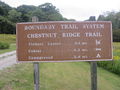
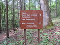
Chestnut Ridge Trail is the highest and steepest and therefore most challenging trail of the Roan Mountain State Park trail system. Offering the most remote and secluded hike within the park. Leave the Miller homestead imagining it's 100 years ago and you're a family member headed to town for some supplies. If you want to get away and not hear cars roaring by for a while, hike this trail. It's recommended to get shuttled or car pool to Miller Homestead parking lot to avoid the very long and steep ascent to return. Hike down to Forest Road Trail and continue to either the Visitor center to the left or head right and make your way back to the cabins or campground.
The trail begins at Miller Homestead and heads east along Chestnut Ridge until it meets up with Forest Road Trail.
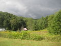
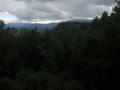
A classic Appalachian hiking trail. You're up on a ridge, but the trees obscure 90% of the view to the surrounding mountains. A winter hike after the leaves have fallen would likely offer wonderful views.
The typical foliage up top is mostly deciduous trees with a few pines. The middle layer is classic Roan Mountain rhododendron, and the ground cover seems to be predominated with ferns.
The trail is decently maintained and likely doesn't see much traffic. It's a fairly narrow trail in parts and the steep descent is lacking steps in most places. A hike up the ridge is likely challenging.
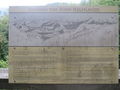
Historical access to Miller Homestead was not by this trail or the current day road. Routine access to town or church was through the back of the property, behind the barn.