Loading map...
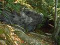
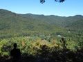
{"format":"googlemaps3","type":"TERRAIN","minzoom":false,"maxzoom":false,"types":["SATELLITE","HYBRID","TERRAIN"],"limit":50,"offset":0,"link":"none","sort":[""],"order":[],"headers":"show","mainlabel":"","intro":"","outro":"","searchlabel":"... further results","default":"","import-annotation":false,"width":"auto","height":"600px","centre":false,"title":"","label":"","icon":"","lines":[],"polygons":[],"circles":[],"rectangles":[],"copycoords":false,"static":false,"visitedicon":"","wmsoverlay":false,"zoom":false,"layers":[],"controls":["pan","zoom","type","scale","streetview","rotate"],"zoomstyle":"DEFAULT","typestyle":"DEFAULT","autoinfowindows":false,"resizable":false,"kmlrezoom":true,"poi":true,"cluster":false,"clustergridsize":60,"clustermaxzoom":20,"clusterzoomonclick":true,"clusteraveragecenter":true,"clusterminsize":2,"imageoverlays":[],"kml":[],"gkml":["https://tehcc.org/clubwiki/images/Forest_Road.kml","https://tehcc.org/clubwiki/images/Raven_Rock.kml"],"searchmarkers":"","fullscreen":false,"scrollwheelzoom":false,"showtitle":false,"hidenamespace":true,"template":"Map Balloon Template","userparam":"","activeicon":"","pagelabel":false,"ajaxcoordproperty":"","ajaxquery":"","locations":[{"text":"\u003Cp\u003E\u003Cb\u003E\u003Ca href=\"/wiki/Forest_Road\" title=\"Forest Road\"\u003EForest Road\u003C/a\u003E\u003C/b\u003E\u003Cbr /\u003E\u003C/p\u003E\u003Chr /\u003E\u003Cp\u003E3.22\u0026#160;Mi (5.19\u0026#160;km)\u003Cbr /\u003EDifficulty: Medium\u003Cbr /\u003EMarking: Purple\u003C/p\u003E","title":"Forest Road","link":"","lat":36.17607000000000283534973277710378170013427734375,"lon":-82.0797500000000042064129956997931003570556640625,"icon":"/clubwiki/images/MarkerT.png"},{"text":"\u003Cp\u003E\u003Cb\u003EIntersection with Raven Rock Trail\u003C/b\u003E\u003Cbr /\u003E\u003C/p\u003E\u003Chr /\u003E\u003Cp\u003EIntersection with Raven Rock Trail\u003C/p\u003E","title":"Forest Road","link":"","lat":36.16292800000000084992279880680143833160400390625,"lon":-82.0921309999999948558979667723178863525390625,"icon":"/clubwiki/images/MarkerT.png"},{"text":"\u003Cp\u003E\u003Cb\u003ETrail split\u003C/b\u003E\u003Cbr /\u003E\u003C/p\u003E\u003Chr /\u003E\u003Cp\u003ETurn right/east to continue, street access to left\u003C/p\u003E","title":"Forest Road","link":"","lat":36.16578200000000009595169103704392910003662109375,"lon":-82.0875840000000067675500758923590183258056640625,"icon":"/clubwiki/images/MarkerT.png"},{"text":"\u003Cp\u003E\u003Cb\u003EConnector to rear of cabins\u003C/b\u003E\u003Cbr /\u003E\u003C/p\u003E\u003Chr /\u003E\u003Cp\u003E\u003Ca href=\"/wiki/File:Roan_Mystery_Mountain_Trail_Monster.jpg\" class=\"image\" title=\"Mystery Mountain Trail Monster\"\u003E\u003Cimg alt=\"Mystery Mountain Trail Monster\" src=\"/clubwiki/images/thumb/Roan_Mystery_Mountain_Trail_Monster.jpg/150px-Roan_Mystery_Mountain_Trail_Monster.jpg\" decoding=\"async\" width=\"150\" height=\"267\" srcset=\"/clubwiki/images/thumb/Roan_Mystery_Mountain_Trail_Monster.jpg/225px-Roan_Mystery_Mountain_Trail_Monster.jpg 1.5x, /clubwiki/images/thumb/Roan_Mystery_Mountain_Trail_Monster.jpg/300px-Roan_Mystery_Mountain_Trail_Monster.jpg 2x\" data-file-width=\"576\" data-file-height=\"1024\" /\u003E\u003C/a\u003E\u003C/p\u003E","title":"Forest Road","link":"","lat":36.1666450000000025966073735617101192474365234375,"lon":-82.0909589999999980136635713279247283935546875,"icon":"/clubwiki/images/MarkerG.png"},{"text":"\u003Cp\u003E\u003Cb\u003ETrail split\u003C/b\u003E\u003Cbr /\u003E\u003C/p\u003E\u003Chr /\u003E\u003Cp\u003Eunknown white left, Forest Road right\u003C/p\u003E","title":"Forest Road","link":"","lat":36.1722409999999996443875716067850589752197265625,"lon":-82.0916289999999975179889588616788387298583984375,"icon":"/clubwiki/images/MarkerT.png"},{"text":"\u003Cp\u003E\u003Cb\u003ERiver swim spot\u003C/b\u003E\u003Cbr /\u003E\u003C/p\u003E\u003Chr /\u003E\u003Cp\u003ETrail splits, trail continues left/north, unknown other direction\u003C/p\u003E","title":"Forest Road","link":"","lat":36.1724099999999992860466591082513332366943359375,"lon":-82.0920430000000038717189454473555088043212890625,"icon":"/clubwiki/images/MarkerL.png"},{"text":"\u003Cp\u003E\u003Cb\u003ETN143 Crossing\u003C/b\u003E\u003Cbr /\u003E\u003C/p\u003E\u003Chr /\u003E\u003Cp\u003ETN143 Crossing\u003C/p\u003E","title":"Forest Road","link":"","lat":36.172866999999996551196090877056121826171875,"lon":-82.092025000000006684786058031022548675537109375,"icon":"/clubwiki/images/MarkerU.png"},{"text":"\u003Cp\u003E\u003Cb\u003ELarge rock along trail\u003C/b\u003E\u003Cbr /\u003E\u003C/p\u003E\u003Chr /\u003E\u003Cp\u003ELarge rock along trail\u003C/p\u003E","title":"Forest Road","link":"","lat":36.17062899999999814326656633056700229644775390625,"lon":-82.0925330000000030850060284137725830078125,"icon":"/clubwiki/images/MarkerG.png"},{"text":"\u003Cp\u003E\u003Cb\u003EAccess to conference center\u003C/b\u003E\u003Cbr /\u003E\u003C/p\u003E\u003Chr /\u003E\u003Cp\u003EStay on blazed trail\u003C/p\u003E","title":"Forest Road","link":"","lat":36.16362600000000071531758294440805912017822265625,"lon":-82.0914020000000022037056623958051204681396484375,"icon":"/clubwiki/images/MarkerG.png"},{"text":"\u003Cp\u003E\u003Cb\u003ELarge rock\u003C/b\u003E\u003Cbr /\u003E\u003C/p\u003E\u003Chr /\u003E\u003Cp\u003ELarge rock\u003C/p\u003E","title":"Forest Road","link":"","lat":36.16498399999999691090124542824923992156982421875,"lon":-82.088515000000001009539118967950344085693359375,"icon":"/clubwiki/images/MarkerG.png"},{"text":"\u003Cp\u003E\u003Cb\u003EConnect with Turkey Trot\u003C/b\u003E\u003Cbr /\u003E\u003C/p\u003E\u003Chr /\u003E\u003Cp\u003EConnect with Turkey Trot\u003C/p\u003E","title":"Forest Road","link":"","lat":36.16992400000000174031811184249818325042724609375,"lon":-82.092524999999994861354934982955455780029296875,"icon":"/clubwiki/images/MarkerT.png"},{"text":"\u003Cp\u003E\u003Cb\u003EAccess to park ranger office\u003C/b\u003E\u003Cbr /\u003E\u003C/p\u003E\u003Chr /\u003E\u003Cp\u003EAccess to park ranger office\u003C/p\u003E","title":"Forest Road","link":"","lat":36.16171299999999888541424297727644443511962890625,"lon":-82.0935869999999994206518749706447124481201171875,"icon":"/clubwiki/images/MarkerT.png"},{"text":"\u003Cp\u003E\u003Cb\u003E\u003Ca class=\"mw-selflink selflink\"\u003ERaven Rock\u003C/a\u003E\u003C/b\u003E\u003Cbr /\u003E\u003C/p\u003E\u003Chr /\u003E\u003Cp\u003E0.97\u0026#160;Mi (1.55\u0026#160;km)\u003Cbr /\u003EDifficulty: Medium\u003Cbr /\u003EMarking: Red\u003C/p\u003E","title":"Raven Rock","link":"","lat":36.15982000000000340378392138518393039703369140625,"lon":-82.09591000000000349245965480804443359375,"icon":"/clubwiki/images/MarkerT.png"},{"text":"\u003Cp\u003E\u003Cb\u003ELarge rock over trail\u003C/b\u003E\u003Cbr /\u003E\u003C/p\u003E\u003Chr /\u003E\u003Cp\u003E\u003Ca href=\"/wiki/File:Roan_Raven_Rock_on_the_trail.jpg\" class=\"image\" title=\"Large rock along the trail\"\u003E\u003Cimg alt=\"Large rock along the trail\" src=\"/clubwiki/images/thumb/Roan_Raven_Rock_on_the_trail.jpg/150px-Roan_Raven_Rock_on_the_trail.jpg\" decoding=\"async\" width=\"150\" height=\"113\" srcset=\"/clubwiki/images/thumb/Roan_Raven_Rock_on_the_trail.jpg/225px-Roan_Raven_Rock_on_the_trail.jpg 1.5x, /clubwiki/images/thumb/Roan_Raven_Rock_on_the_trail.jpg/300px-Roan_Raven_Rock_on_the_trail.jpg 2x\" data-file-width=\"1280\" data-file-height=\"960\" /\u003E\u003C/a\u003E\u003C/p\u003E","title":"Raven Rock","link":"","lat":36.15977500000000333102434524334967136383056640625,"lon":-82.0937569999999965375536703504621982574462890625,"icon":"/clubwiki/images/MarkerG.png"},{"text":"\u003Cp\u003E\u003Cb\u003ETrail high point\u003C/b\u003E\u003Cbr /\u003E\u003C/p\u003E\u003Chr /\u003E\u003Cp\u003ETrail splits, proper way marked, unknown trail the other way\u003C/p\u003E","title":"Raven Rock","link":"","lat":36.15934299999999979036147124134004116058349609375,"lon":-82.092183000000005677065928466618061065673828125,"icon":"/clubwiki/images/MarkerG.png"},{"text":"\u003Cp\u003E\u003Cb\u003EOverlook\u003C/b\u003E\u003Cbr /\u003E\u003C/p\u003E\u003Chr /\u003E\u003Cp\u003E\u003Ca href=\"/wiki/File:Roan_View_from_Raven_Rock.jpg\" class=\"image\" title=\"View from the outlook\"\u003E\u003Cimg alt=\"View from the outlook\" src=\"/clubwiki/images/thumb/Roan_View_from_Raven_Rock.jpg/150px-Roan_View_from_Raven_Rock.jpg\" decoding=\"async\" width=\"150\" height=\"113\" srcset=\"/clubwiki/images/thumb/Roan_View_from_Raven_Rock.jpg/225px-Roan_View_from_Raven_Rock.jpg 1.5x, /clubwiki/images/thumb/Roan_View_from_Raven_Rock.jpg/300px-Roan_View_from_Raven_Rock.jpg 2x\" data-file-width=\"1280\" data-file-height=\"960\" /\u003E\u003C/a\u003E\u003C/p\u003E","title":"Raven Rock","link":"","lat":36.16023700000000218324203160591423511505126953125,"lon":-82.0932719999999989113348419778048992156982421875,"icon":"/clubwiki/images/MarkerE.png"}]}
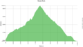
A fairly easy hike with a great lookout payoff. Use this trail as a destination or an excursion of a longer circuit using Forest Road Trail or other trails. With its proximity to the campground, anyone staying the night there should take the time for the hike and the view.
Route description based on starting from Forest Road Trail head near the campground
Being a TN state park, the dirt and gravel trails are kept in good condition. Some of the trail sections are steep, thus can be slippery after a rain.