Loading map...
{"format":"googlemaps3","type":"TERRAIN","minzoom":false,"maxzoom":false,"types":["SATELLITE","HYBRID","TERRAIN"],"limit":50,"offset":0,"link":"none","sort":[""],"order":[],"headers":"show","mainlabel":"","intro":"","outro":"","searchlabel":"... further results","default":"","import-annotation":false,"width":"auto","height":"600px","centre":false,"title":"","label":"","icon":"","lines":[],"polygons":[],"circles":[],"rectangles":[],"copycoords":false,"static":false,"visitedicon":"","wmsoverlay":false,"zoom":false,"layers":[],"controls":["pan","zoom","type","scale","streetview","rotate"],"zoomstyle":"DEFAULT","typestyle":"DEFAULT","autoinfowindows":false,"resizable":false,"kmlrezoom":true,"poi":true,"cluster":false,"clustergridsize":60,"clustermaxzoom":20,"clusterzoomonclick":true,"clusteraveragecenter":true,"clusterminsize":2,"imageoverlays":[],"kml":[],"gkml":["https://tehcc.org/clubwiki/images/Chestnut_Ridge.kml","https://tehcc.org/clubwiki/images/Forest_Road.kml","https://tehcc.org/clubwiki/images/Raven_Rock.kml","https://tehcc.org/clubwiki/images/Turkey_Trot.kml"],"searchmarkers":"","fullscreen":false,"scrollwheelzoom":false,"showtitle":false,"hidenamespace":true,"template":"Map Balloon Template","userparam":"","activeicon":"","pagelabel":false,"ajaxcoordproperty":"","ajaxquery":"","locations":[{"text":"\u003Cp\u003E\u003Cb\u003E\u003Ca href=\"/wiki/Chestnut_Ridge\" title=\"Chestnut Ridge\"\u003EChestnut Ridge\u003C/a\u003E\u003C/b\u003E\u003Cbr /\u003E\u003C/p\u003E\u003Chr /\u003E\u003Cp\u003E2.19\u0026#160;Mi (3.53\u0026#160;km)\u003Cbr /\u003EDifficulty: Medium\u003Cbr /\u003EMarking: Orange\u003C/p\u003E","title":"Chestnut Ridge","link":"","lat":36.1782699999999977080733515322208404541015625,"lon":-82.1123400000000032150637707673013210296630859375,"icon":"/clubwiki/images/MarkerT.png"},{"text":"\u003Cp\u003E\u003Cb\u003EParking\u003C/b\u003E\u003Cbr /\u003E\u003C/p\u003E\u003Chr /\u003E\u003Cp\u003EParking\u003C/p\u003E","title":"Chestnut Ridge","link":"","lat":36.178776999999996633050614036619663238525390625,"lon":-82.11263700000000653744791634380817413330078125,"icon":"/clubwiki/images/MarkerA.png"},{"text":"\u003Cp\u003E\u003Cb\u003ETrail head\u003C/b\u003E\u003Cbr /\u003E\u003C/p\u003E\u003Chr /\u003E\u003Cp\u003E\u003Ca href=\"/wiki/File:Roan_Chestnut_Miller_Trail_head.jpg\" class=\"image\" title=\"Trail head at Miller Homestead\"\u003E\u003Cimg alt=\"Trail head at Miller Homestead\" src=\"/clubwiki/images/thumb/Roan_Chestnut_Miller_Trail_head.jpg/150px-Roan_Chestnut_Miller_Trail_head.jpg\" decoding=\"async\" width=\"150\" height=\"113\" srcset=\"/clubwiki/images/thumb/Roan_Chestnut_Miller_Trail_head.jpg/225px-Roan_Chestnut_Miller_Trail_head.jpg 1.5x, /clubwiki/images/thumb/Roan_Chestnut_Miller_Trail_head.jpg/300px-Roan_Chestnut_Miller_Trail_head.jpg 2x\" data-file-width=\"2816\" data-file-height=\"2112\" /\u003E\u003C/a\u003E\u003C/p\u003E","title":"Chestnut Ridge","link":"","lat":36.1782680000000027575879357755184173583984375,"lon":-82.1123410000000006903064786456525325775146484375,"icon":"/clubwiki/images/MarkerG.png"},{"text":"\u003Cp\u003E\u003Cb\u003EJunction with \u003Ca class=\"mw-selflink selflink\"\u003EForest Road Trail\u003C/a\u003E\u003C/b\u003E\u003Cbr /\u003E\u003C/p\u003E\u003Chr /\u003E\u003Cp\u003E\u003Ca href=\"/wiki/File:Roan_intersection_of_Chestnut_and_Forest_Road.jpg\" class=\"image\" title=\"Intersection of Chestnut and Forest Road\"\u003E\u003Cimg alt=\"Intersection of Chestnut and Forest Road\" src=\"/clubwiki/images/thumb/Roan_intersection_of_Chestnut_and_Forest_Road.jpg/150px-Roan_intersection_of_Chestnut_and_Forest_Road.jpg\" decoding=\"async\" width=\"150\" height=\"113\" srcset=\"/clubwiki/images/thumb/Roan_intersection_of_Chestnut_and_Forest_Road.jpg/225px-Roan_intersection_of_Chestnut_and_Forest_Road.jpg 1.5x, /clubwiki/images/thumb/Roan_intersection_of_Chestnut_and_Forest_Road.jpg/300px-Roan_intersection_of_Chestnut_and_Forest_Road.jpg 2x\" data-file-width=\"2816\" data-file-height=\"2112\" /\u003E\u003C/a\u003E\u003C/p\u003E","title":"Chestnut Ridge","link":"","lat":36.17318499999999659166860510595142841339111328125,"lon":-82.0906580000000047903085942380130290985107421875,"icon":"/clubwiki/images/MarkerT.png"},{"text":"\u003Cp\u003E\u003Cb\u003EViewing platform\u003C/b\u003E\u003Cbr /\u003E\u003C/p\u003E\u003Chr /\u003E\u003Cp\u003E\u003Ca href=\"/wiki/File:Roan_view_from_Miller_cemetery_platform.jpg\" class=\"image\" title=\"View from platform\"\u003E\u003Cimg alt=\"View from platform\" src=\"/clubwiki/images/thumb/Roan_view_from_Miller_cemetery_platform.jpg/150px-Roan_view_from_Miller_cemetery_platform.jpg\" decoding=\"async\" width=\"150\" height=\"113\" srcset=\"/clubwiki/images/thumb/Roan_view_from_Miller_cemetery_platform.jpg/225px-Roan_view_from_Miller_cemetery_platform.jpg 1.5x, /clubwiki/images/thumb/Roan_view_from_Miller_cemetery_platform.jpg/300px-Roan_view_from_Miller_cemetery_platform.jpg 2x\" data-file-width=\"2816\" data-file-height=\"2112\" /\u003E\u003C/a\u003E\u003C/p\u003E","title":"Chestnut Ridge","link":"","lat":36.18015100000000217050910578109323978424072265625,"lon":-82.1109019999999958372427499853074550628662109375,"icon":"/clubwiki/images/MarkerE.png"},{"text":"\u003Cp\u003E\u003Cb\u003ECemetery\u003C/b\u003E\u003Cbr /\u003E\u003C/p\u003E\u003Chr /\u003E\u003Cp\u003ECemetery\u003C/p\u003E","title":"Chestnut Ridge","link":"","lat":36.1805650000000014188117347657680511474609375,"lon":-82.1108980000000059362719184719026088714599609375,"icon":"/clubwiki/images/MarkerN.png"},{"text":"\u003Cp\u003E\u003Cb\u003E\u003Ca class=\"mw-selflink selflink\"\u003EForest Road\u003C/a\u003E\u003C/b\u003E\u003Cbr /\u003E\u003C/p\u003E\u003Chr /\u003E\u003Cp\u003E3.22\u0026#160;Mi (5.19\u0026#160;km)\u003Cbr /\u003EDifficulty: Medium\u003Cbr /\u003EMarking: Purple\u003C/p\u003E","title":"Forest Road","link":"","lat":36.17607000000000283534973277710378170013427734375,"lon":-82.0797500000000042064129956997931003570556640625,"icon":"/clubwiki/images/MarkerT.png"},{"text":"\u003Cp\u003E\u003Cb\u003EIntersection with Raven Rock Trail\u003C/b\u003E\u003Cbr /\u003E\u003C/p\u003E\u003Chr /\u003E\u003Cp\u003EIntersection with Raven Rock Trail\u003C/p\u003E","title":"Forest Road","link":"","lat":36.16292800000000084992279880680143833160400390625,"lon":-82.0921309999999948558979667723178863525390625,"icon":"/clubwiki/images/MarkerT.png"},{"text":"\u003Cp\u003E\u003Cb\u003ETrail split\u003C/b\u003E\u003Cbr /\u003E\u003C/p\u003E\u003Chr /\u003E\u003Cp\u003ETurn right/east to continue, street access to left\u003C/p\u003E","title":"Forest Road","link":"","lat":36.16578200000000009595169103704392910003662109375,"lon":-82.0875840000000067675500758923590183258056640625,"icon":"/clubwiki/images/MarkerT.png"},{"text":"\u003Cp\u003E\u003Cb\u003EConnector to rear of cabins\u003C/b\u003E\u003Cbr /\u003E\u003C/p\u003E\u003Chr /\u003E\u003Cp\u003E\u003Ca href=\"/wiki/File:Roan_Mystery_Mountain_Trail_Monster.jpg\" class=\"image\" title=\"Mystery Mountain Trail Monster\"\u003E\u003Cimg alt=\"Mystery Mountain Trail Monster\" src=\"/clubwiki/images/thumb/Roan_Mystery_Mountain_Trail_Monster.jpg/150px-Roan_Mystery_Mountain_Trail_Monster.jpg\" decoding=\"async\" width=\"150\" height=\"267\" srcset=\"/clubwiki/images/thumb/Roan_Mystery_Mountain_Trail_Monster.jpg/225px-Roan_Mystery_Mountain_Trail_Monster.jpg 1.5x, /clubwiki/images/thumb/Roan_Mystery_Mountain_Trail_Monster.jpg/300px-Roan_Mystery_Mountain_Trail_Monster.jpg 2x\" data-file-width=\"576\" data-file-height=\"1024\" /\u003E\u003C/a\u003E\u003C/p\u003E","title":"Forest Road","link":"","lat":36.1666450000000025966073735617101192474365234375,"lon":-82.0909589999999980136635713279247283935546875,"icon":"/clubwiki/images/MarkerG.png"},{"text":"\u003Cp\u003E\u003Cb\u003ETrail split\u003C/b\u003E\u003Cbr /\u003E\u003C/p\u003E\u003Chr /\u003E\u003Cp\u003Eunknown white left, Forest Road right\u003C/p\u003E","title":"Forest Road","link":"","lat":36.1722409999999996443875716067850589752197265625,"lon":-82.0916289999999975179889588616788387298583984375,"icon":"/clubwiki/images/MarkerT.png"},{"text":"\u003Cp\u003E\u003Cb\u003ERiver swim spot\u003C/b\u003E\u003Cbr /\u003E\u003C/p\u003E\u003Chr /\u003E\u003Cp\u003ETrail splits, trail continues left/north, unknown other direction\u003C/p\u003E","title":"Forest Road","link":"","lat":36.1724099999999992860466591082513332366943359375,"lon":-82.0920430000000038717189454473555088043212890625,"icon":"/clubwiki/images/MarkerL.png"},{"text":"\u003Cp\u003E\u003Cb\u003ETN143 Crossing\u003C/b\u003E\u003Cbr /\u003E\u003C/p\u003E\u003Chr /\u003E\u003Cp\u003ETN143 Crossing\u003C/p\u003E","title":"Forest Road","link":"","lat":36.172866999999996551196090877056121826171875,"lon":-82.092025000000006684786058031022548675537109375,"icon":"/clubwiki/images/MarkerU.png"},{"text":"\u003Cp\u003E\u003Cb\u003ELarge rock along trail\u003C/b\u003E\u003Cbr /\u003E\u003C/p\u003E\u003Chr /\u003E\u003Cp\u003ELarge rock along trail\u003C/p\u003E","title":"Forest Road","link":"","lat":36.17062899999999814326656633056700229644775390625,"lon":-82.0925330000000030850060284137725830078125,"icon":"/clubwiki/images/MarkerG.png"},{"text":"\u003Cp\u003E\u003Cb\u003EAccess to conference center\u003C/b\u003E\u003Cbr /\u003E\u003C/p\u003E\u003Chr /\u003E\u003Cp\u003EStay on blazed trail\u003C/p\u003E","title":"Forest Road","link":"","lat":36.16362600000000071531758294440805912017822265625,"lon":-82.0914020000000022037056623958051204681396484375,"icon":"/clubwiki/images/MarkerG.png"},{"text":"\u003Cp\u003E\u003Cb\u003ELarge rock\u003C/b\u003E\u003Cbr /\u003E\u003C/p\u003E\u003Chr /\u003E\u003Cp\u003ELarge rock\u003C/p\u003E","title":"Forest Road","link":"","lat":36.16498399999999691090124542824923992156982421875,"lon":-82.088515000000001009539118967950344085693359375,"icon":"/clubwiki/images/MarkerG.png"},{"text":"\u003Cp\u003E\u003Cb\u003EConnect with Turkey Trot\u003C/b\u003E\u003Cbr /\u003E\u003C/p\u003E\u003Chr /\u003E\u003Cp\u003EConnect with Turkey Trot\u003C/p\u003E","title":"Forest Road","link":"","lat":36.16992400000000174031811184249818325042724609375,"lon":-82.092524999999994861354934982955455780029296875,"icon":"/clubwiki/images/MarkerT.png"},{"text":"\u003Cp\u003E\u003Cb\u003EAccess to park ranger office\u003C/b\u003E\u003Cbr /\u003E\u003C/p\u003E\u003Chr /\u003E\u003Cp\u003EAccess to park ranger office\u003C/p\u003E","title":"Forest Road","link":"","lat":36.16171299999999888541424297727644443511962890625,"lon":-82.0935869999999994206518749706447124481201171875,"icon":"/clubwiki/images/MarkerT.png"},{"text":"\u003Cp\u003E\u003Cb\u003E\u003Ca href=\"/wiki/Raven_Rock\" title=\"Raven Rock\"\u003ERaven Rock\u003C/a\u003E\u003C/b\u003E\u003Cbr /\u003E\u003C/p\u003E\u003Chr /\u003E\u003Cp\u003E0.97\u0026#160;Mi (1.55\u0026#160;km)\u003Cbr /\u003EDifficulty: Medium\u003Cbr /\u003EMarking: Red\u003C/p\u003E","title":"Raven Rock","link":"","lat":36.15982000000000340378392138518393039703369140625,"lon":-82.09591000000000349245965480804443359375,"icon":"/clubwiki/images/MarkerT.png"},{"text":"\u003Cp\u003E\u003Cb\u003ELarge rock over trail\u003C/b\u003E\u003Cbr /\u003E\u003C/p\u003E\u003Chr /\u003E\u003Cp\u003E\u003Ca href=\"/wiki/File:Roan_Raven_Rock_on_the_trail.jpg\" class=\"image\" title=\"Large rock along the trail\"\u003E\u003Cimg alt=\"Large rock along the trail\" src=\"/clubwiki/images/thumb/Roan_Raven_Rock_on_the_trail.jpg/150px-Roan_Raven_Rock_on_the_trail.jpg\" decoding=\"async\" width=\"150\" height=\"113\" srcset=\"/clubwiki/images/thumb/Roan_Raven_Rock_on_the_trail.jpg/225px-Roan_Raven_Rock_on_the_trail.jpg 1.5x, /clubwiki/images/thumb/Roan_Raven_Rock_on_the_trail.jpg/300px-Roan_Raven_Rock_on_the_trail.jpg 2x\" data-file-width=\"1280\" data-file-height=\"960\" /\u003E\u003C/a\u003E\u003C/p\u003E","title":"Raven Rock","link":"","lat":36.15977500000000333102434524334967136383056640625,"lon":-82.0937569999999965375536703504621982574462890625,"icon":"/clubwiki/images/MarkerG.png"},{"text":"\u003Cp\u003E\u003Cb\u003ETrail high point\u003C/b\u003E\u003Cbr /\u003E\u003C/p\u003E\u003Chr /\u003E\u003Cp\u003ETrail splits, proper way marked, unknown trail the other way\u003C/p\u003E","title":"Raven Rock","link":"","lat":36.15934299999999979036147124134004116058349609375,"lon":-82.092183000000005677065928466618061065673828125,"icon":"/clubwiki/images/MarkerG.png"},{"text":"\u003Cp\u003E\u003Cb\u003EOverlook\u003C/b\u003E\u003Cbr /\u003E\u003C/p\u003E\u003Chr /\u003E\u003Cp\u003E\u003Ca href=\"/wiki/File:Roan_View_from_Raven_Rock.jpg\" class=\"image\" title=\"View from the outlook\"\u003E\u003Cimg alt=\"View from the outlook\" src=\"/clubwiki/images/thumb/Roan_View_from_Raven_Rock.jpg/150px-Roan_View_from_Raven_Rock.jpg\" decoding=\"async\" width=\"150\" height=\"113\" srcset=\"/clubwiki/images/thumb/Roan_View_from_Raven_Rock.jpg/225px-Roan_View_from_Raven_Rock.jpg 1.5x, /clubwiki/images/thumb/Roan_View_from_Raven_Rock.jpg/300px-Roan_View_from_Raven_Rock.jpg 2x\" data-file-width=\"1280\" data-file-height=\"960\" /\u003E\u003C/a\u003E\u003C/p\u003E","title":"Raven Rock","link":"","lat":36.16023700000000218324203160591423511505126953125,"lon":-82.0932719999999989113348419778048992156982421875,"icon":"/clubwiki/images/MarkerE.png"},{"text":"\u003Cp\u003E\u003Cb\u003E\u003Ca href=\"/wiki/Turkey_Trot\" title=\"Turkey Trot\"\u003ETurkey Trot\u003C/a\u003E\u003C/b\u003E\u003Cbr /\u003E\u003C/p\u003E\u003Chr /\u003E\u003Cp\u003E0.41\u0026#160;Mi (0.66\u0026#160;km)\u003Cbr /\u003EDifficulty: Medium\u003Cbr /\u003EMarking: Red\u003C/p\u003E","title":"Turkey Trot","link":"","lat":36.16734999999999899955582804977893829345703125,"lon":-82.094210000000003901732270605862140655517578125,"icon":"/clubwiki/images/MarkerT.png"},{"text":"\u003Cp\u003E\u003Cb\u003ETrail terminus at cabins\u003C/b\u003E\u003Cbr /\u003E\u003C/p\u003E\u003Chr /\u003E\u003Cp\u003ETrail terminus at cabins\u003C/p\u003E","title":"Turkey Trot","link":"","lat":36.16735200000000105546860140748322010040283203125,"lon":-82.094209000000006426489562727510929107666015625,"icon":"/clubwiki/images/MarkerG.png"},{"text":"\u003Cp\u003E\u003Cb\u003EUnknown trail intersection\u003C/b\u003E\u003Cbr /\u003E\u003C/p\u003E\u003Chr /\u003E\u003Cp\u003E\u003Ca href=\"/wiki/File:Roan_Turkey_Trot_sign.jpg\" class=\"image\" title=\"mid-trail sign\"\u003E\u003Cimg alt=\"mid-trail sign\" src=\"/clubwiki/images/thumb/Roan_Turkey_Trot_sign.jpg/150px-Roan_Turkey_Trot_sign.jpg\" decoding=\"async\" width=\"150\" height=\"119\" srcset=\"/clubwiki/images/thumb/Roan_Turkey_Trot_sign.jpg/225px-Roan_Turkey_Trot_sign.jpg 1.5x, /clubwiki/images/thumb/Roan_Turkey_Trot_sign.jpg/300px-Roan_Turkey_Trot_sign.jpg 2x\" data-file-width=\"1095\" data-file-height=\"870\" /\u003E\u003C/a\u003E\u003C/p\u003E","title":"Turkey Trot","link":"","lat":36.16861800000000215504769585095345973968505859375,"lon":-82.0951730000000026166162570007145404815673828125,"icon":"/clubwiki/images/MarkerT.png"},{"text":"\u003Cp\u003E\u003Cb\u003EIntersection with Forest Road Trail\u003C/b\u003E\u003Cbr /\u003E\u003C/p\u003E\u003Chr /\u003E\u003Cp\u003E\u003Ca href=\"/wiki/File:Roan_Forest_Road_and_Turkey_Trot.jpg\" class=\"image\" title=\"Intersection of Forest Road and Turkey Trot Trails\"\u003E\u003Cimg alt=\"Intersection of Forest Road and Turkey Trot Trails\" src=\"/clubwiki/images/thumb/Roan_Forest_Road_and_Turkey_Trot.jpg/150px-Roan_Forest_Road_and_Turkey_Trot.jpg\" decoding=\"async\" width=\"150\" height=\"84\" srcset=\"/clubwiki/images/thumb/Roan_Forest_Road_and_Turkey_Trot.jpg/225px-Roan_Forest_Road_and_Turkey_Trot.jpg 1.5x, /clubwiki/images/thumb/Roan_Forest_Road_and_Turkey_Trot.jpg/300px-Roan_Forest_Road_and_Turkey_Trot.jpg 2x\" data-file-width=\"1280\" data-file-height=\"720\" /\u003E\u003C/a\u003E\u003C/p\u003E","title":"Turkey Trot","link":"","lat":36.16992400000000174031811184249818325042724609375,"lon":-82.092524999999994861354934982955455780029296875,"icon":"/clubwiki/images/MarkerT.png"}]}
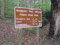
The northern trail head begins across the street from the Visitor Center marked as part of the Boundary Trail System.
Trail begins at the Visitor Center and heads south then west until turning south again to cross 143. Afterwards it continues south behind the cabins, and ranger residence until it terminates at the Campground entrance on 143.
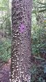
The northern section can be very rocky and rugged at parts. Trail is well blazed and most trail splits are clearly marked or a trail blaze can be seen down the proper trail to take.