Turkey Trot: Difference between revisions
m (cleanup cats) |
m (add needs) |
||
| Line 1: | Line 1: | ||
<!-- The following few lines create the "Infobox" table template. Please scroll down to edit the main content of the article. --> | <!-- The following few lines create the "Infobox" table template. Please scroll down to edit the main content of the article. | ||
{{Infobox Trail | |||
-->{{Infobox Trail | |||
| Image Name = Roan Turkey Trot sign.jpg | | Image Name = Roan Turkey Trot sign.jpg | ||
| Park = Roan Mountain State Park | | Park = Roan Mountain State Park | ||
| Line 18: | Line 19: | ||
| Trailhead coords = 36.167352,-82.094209 | | Trailhead coords = 36.167352,-82.094209 | ||
| Medical = Elizabethton, TN | | Medical = Elizabethton, TN | ||
}} | }}<!-- | ||
<!-- End Infobox template table--> | |||
<!-- Start of Main Page --> | End Infobox template table | ||
-->{{Trail page needs | |||
| Hide needs = Yes | |||
| KML = | |||
| Updated KML = | |||
| Detail route description = | |||
| Photos = | |||
| Winter photos = | |||
| Remove prefix = | |||
| Update infobox = | |||
| Infobox data update = | |||
| Trail pins = | |||
| Other = | |||
| Comment = Looks good given significance/length | |||
| Date reviewed = 1/2/2016 | |||
}}<!-- | |||
Start of Main Page --> | |||
== Trail Overview == | == Trail Overview == | ||
<!-- Enter a overview of the trail. What attracts you to this trail, points of interest, types of flowers, lakes, and peaks that you see along the way. --> | <!-- Enter a overview of the trail. What attracts you to this trail, points of interest, types of flowers, lakes, and peaks that you see along the way. --> | ||
Revision as of 23:08, 2 January 2016
| |||||||||||||||||||||||||||||||||||||||||||||

Trail Overview
This is part of the Roan Mountain State Park trail system and can be used as part of a circuit from the campground or the cabins using one of the many access trails along this and Forest Road Trail.
How to get there
From Johnson City (I-26 Exit 24):
- Take TN67/US321 over to Elizabethton (about eight miles).
- Turn right/south at traffic light for TN37/US19E/US321 and travel for 17 miles.
- Turn right/south for TN143 for five miles to park visitors center.
- Trailheads are in several places around the park.
GPS address is 1015 Hwy 143 Roan Mountain, TN 37687.
Route Description
A spur off of Forest Road Trail. Likely use is for cabin renters to get to the Forest Road Trail to for options of making it to the Visitor's Center, Raven Rock, or for the really adventurous the Miller Homestead.
Typical Conditions
Being a TN state park, the dirt and gravel trails are kept in good condition. Some of the trail sections are steep, thus can be slippery after a rain.
Misc. Information
Maps
Turkey Trot Trail is shown below in its blaze color red.
Photos
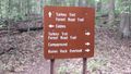
Intersection of Forest Road and Turkey Trot Trails
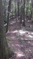
View of the trail

