TN91 to US421: Difference between revisions
(→TN91: Noted that north side parking lot has a handicap sign) |
(→Osborne Farm: "Recent" was 2001. Time to update the reference.) |
||
| Line 22: | Line 22: | ||
== Osborne Farm == | == Osborne Farm == | ||
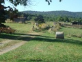
Osborne Farm | Osborne Farm tract was acquired by the ATC and Cherokee National Forest in 2001 for the protection of the AT. A 0.5 mile section is built to accessible standards through beautiful pasture with views of Shady Valley and Mt. Rogers area. Easy hike to end of field is slightly less than a mile before entering the woods going towards Double Springs Shelter. | ||
== Double Springs Shelter == | == Double Springs Shelter == | ||
Revision as of 05:41, 12 October 2015

| ||
| Section | 4ab-5 | |
| Trail south point | TN91 | |
| Trail north point | US421 | |
| Distance | 6.5 Miles | |
| Min Elevation | 3,450 Feet | |
| Max Elevation | 4,080' Feet | |
| Governing Body | Watauga | |
|
|
||
| Show Large Map | ||
(Trail South > North)
TN91
Located at the ridge crest of Cross Mountain between Stoney Creek and Shady Valley at Osborne Farm. There are two parking areas at the highway - space for three vehicles on north side (designated handicap) and 10-12 on the south by the Cherokee National Forest information display.
Osborne Farm
Osborne Farm tract was acquired by the ATC and Cherokee National Forest in 2001 for the protection of the AT. A 0.5 mile section is built to accessible standards through beautiful pasture with views of Shady Valley and Mt. Rogers area. Easy hike to end of field is slightly less than a mile before entering the woods going towards Double Springs Shelter.
Double Springs Shelter
Double Springs Shelter (4060') is a concrete block shelter built by the United States Forest Service in 1960. It is located at the junction of Holston and Cross Mountains.
Holston Mountain Trail
Holston Mountain Trail is a 9.5 mile blue blaze trail that was once part of the AT. It follows the ridgeline toward Holston Mountain High Knob above South Holston Lake and Stoney Creek township.
Low Gap - US421
Road crossing at US421. This is the closest access point to Bristol, TN/VA. Small parking area along roadside.
Recent Conditions
1/21/2014 - Reports are in of repeated vandalism at the Cross Mountain trailhead. Either do not leave vehicles here for extended periods of time or hide/lockup/take with you any valuables from your vehicle.
Photos
Osborne Tract