Forest Road: Difference between revisions
(Add photos) |
m (remove marker with raven rock since that's its trailhead coords) |
||
| (12 intermediate revisions by the same user not shown) | |||
| Line 1: | Line 1: | ||
{{Trail | |||
{{ | |Banner Image=File:Roan Forest Road Purple Blaze.jpg | ||
|Park=Roan Mountain State Park | |||
|Trail Marking=Purple | |||
|Trail Use=Hiking, Fishing | |||
|Difficulty Rating=Medium | |||
|Hike Time=2 hrs | |||
|Trail Distance=3.223 mi | |||
|Round Trip Distance=6.4 mi | |||
|Trail Type=In-and-Out | |||
|High Point=3,097 ft | |||
|Low Point=2,674 ft | |||
|Elevation Gain=755 ft | |||
|Elevation Loss=486 ft | |||
|Elevation Change Direction=North-to-South | |||
|Parking location=36.17654, -82.0794 | |||
|Trailhead location=36.17607, -82.07975 | |||
}} | }} | ||
{{Trail Map|Other Trails=Chestnut Ridge,Raven Rock,Turkey Trot}} | |||
__TOC__ | |||
== Trail Overview == | == Trail Overview == | ||
The longest trail within the [[Roan Mountain State Park]] trail system. It largely follows 143 (including all of its road noise) connecting the Visitor Center with the Conference Center, Cabins, and Campground. The {{#show: Raven Rock | ?Trail distance round trip }} hike of Raven Rock is accessed from this trail. | The longest trail within the [[Roan Mountain State Park]] trail system. It largely follows 143 (including all of its road noise) connecting the Visitor Center with the Conference Center, Cabins, and Campground. The {{#show: Raven Rock | ?Trail distance round trip }} hike of Raven Rock is accessed from this trail. | ||
| Line 30: | Line 29: | ||
== Route Description== | == Route Description== | ||
[[File:Forest road profile.png|thumb|right]] | |||
Trail begins at the Visitor Center and heads south then west until turning south again to cross 143. Afterwards it continues south behind the cabins, and ranger residence until it terminates at the Campground entrance on 143. | Trail begins at the Visitor Center and heads south then west until turning south again to cross 143. Afterwards it continues south behind the cabins, and ranger residence until it terminates at the Campground entrance on 143. | ||
{| class="wikitable" border="1" | |||
|- | |||
!Miles Out | |||
!{{PAGENAME}} | |||
!Miles Back | |||
!Elevation (ft) | |||
|- | |||
|0.0 | |||
|Trail head at Visitor's Center | |||
|3.27 | |||
|2,677 | |||
|- | |||
|0.3 | |||
|Difficult to pass blow down | |||
|2.97 | |||
|2,806 | |||
|- | |||
|1.17 | |||
|Intersection with Chestnut Ridge Trail | |||
|2.1 | |||
|2,902 | |||
|- | |||
|1.32 | |||
|Cross TN 143 and Doe River | |||
|1.95 | |||
|2,818 | |||
|- | |||
|1.8 | |||
|Intersection with Turkey Trot Trail<br>Trail high point | |||
|1.47 | |||
|3,133 | |||
|- | |||
|2.14 | |||
|Cabin area access<br>Mystery Mountain Trail Monster | |||
|1.13 | |||
|2,978 | |||
|- | |||
|2.36 | |||
|Tom Birchfield Rd access | |||
|0.91 | |||
|2,839 | |||
|- | |||
|2.47 | |||
|Large boulders | |||
|0.8 | |||
|2,946 | |||
|- | |||
|2.68 | |||
|Conference Center access | |||
|0.59 | |||
|3,055 | |||
|- | |||
|2.76 | |||
|Raven Rock Trail access | |||
|0.51 | |||
|3,039 | |||
|- | |||
|2.92 | |||
|Park offices access | |||
|0.35 | |||
|3,055 | |||
|- | |||
|3.15 | |||
|Raven Rock Trail Access | |||
|0.12 | |||
|2,677 | |||
|- | |||
|3.27 | |||
|Trail head at TN143 near campground | |||
|0.0 | |||
|2,940 | |||
|} | |||
Accessible from this trail is [[Trail connects to::Chestnut Ridge]], [[Trail connects to::Turkey Trot]], and [[Trail connects to::Raven Rock]]. | Accessible from this trail is [[Trail connects to::Chestnut Ridge]], [[Trail connects to::Turkey Trot]], and [[Trail connects to::Raven Rock]]. | ||
| Line 38: | Line 110: | ||
<!-- Typical conditions throughout the year of what to expect on the trail. Rocky, muddy, sandy, flowers, lots of downed trees? --> | <!-- Typical conditions throughout the year of what to expect on the trail. Rocky, muddy, sandy, flowers, lots of downed trees? --> | ||
The northern section can be very rocky and rugged at parts. Trail is well blazed and most trail splits are clearly marked or a trail blaze can be seen down the proper trail to take. | The northern section can be very rocky and rugged at parts. Trail is well blazed and most trail splits are clearly marked or a trail blaze can be seen down the proper trail to take. | ||
== Photos == | == Photos == | ||
{{Park trail gallery|Trail={{PAGENAME}}}} | |||
{{Map Marker | |||
|Icon Type=Road crossing | |||
Image:Roan | |Marker Title=TN143 Crossing | ||
|Marker Location=36.172867,-82.092025 | |||
}} | |||
{{Map Marker | |||
|Icon Type=Trail bridge | |||
|Marker Title=River swim spot | |||
|Marker Description=Trail splits, trail continues left/north, unknown other direction | |||
|Marker Location=36.17241,-82.092043 | |||
}} | |||
{{Map Marker | |||
|Icon Type=Trail sign | |||
|Marker Title=Trail split | |||
|Marker Description=unknown white left, Forest Road right | |||
|Marker Location=36.172241,-82.091629 | |||
}} | |||
{{Map Marker | |||
|Icon Type=Point of interest | |||
|Marker Title=Large rock along trail | |||
|Marker Location=36.170629,-82.092533 | |||
}} | |||
{{Map Marker | |||
|Icon Type=Trail sign | |||
|Marker Title=Connect with Turkey Trot | |||
|Marker Location=36.169924,-82.092525 | |||
}} | |||
{{Map Marker | |||
|Icon Type=Point of interest | |||
|Marker Title=Connector to rear of cabins | |||
|Marker Description=[[Image:Roan Mystery Mountain Trail Monster.jpg|150px|Mystery Mountain Trail Monster]] | |||
|Marker Location=36.166645,-82.090959 | |||
}} | |||
{{Map Marker | |||
|Icon Type=Trail sign | |||
|Marker Title=Trail split | |||
|Marker Description=Turn right/east to continue, street access to left | |||
|Marker Location=36.165782,-82.087584 | |||
}} | |||
{{Map Marker | |||
|Icon Type=Point of interest | |||
|Marker Title=Large rock | |||
|Marker Location=36.164984,-82.088515 | |||
}} | |||
{{Map Marker | |||
|Icon Type=Point of interest | |||
|Marker Title=Access to conference center | |||
|Marker Description=Stay on blazed trail | |||
|Marker Location=36.163626,-82.091402 | |||
}} | |||
{{Map Marker | |||
|Icon Type=Trail sign | |||
|Marker Title=Intersection with Raven Rock Trail | |||
|Marker Location=36.162928,-82.092131 | |||
}} | |||
{{Map Marker | |||
|Icon Type=Trail sign | |||
|Marker Title=Access to park ranger office | |||
|Marker Location=36.161713,-82.093587 | |||
}} | |||
Latest revision as of 13:13, 28 December 2019
| Forest Road (log in to submit report) | |
|---|---|

| |
| Park | Roan Mountain State Park |
| Located | Roan Mountain, TennesseeLocation inherited from associated park |
| Trail Marking | Purple |
| Trail UseThings allowed to do on or near the trail |
|
| FeaturesThings to see on or near the trail |
|
| Difficulty Rating | Medium |
| Hiking TimeTime from car and back. Includes any time hiking to access this trail. | 2 hrs0.125 Days <br />120 Min <br /> round trip |
| Distance: | 3.223 mi5.187 km <br /> trailStrict non-repeating trail length / 6.4 mi10.3 km <br /> round tripTypical or shortest length from the car, hike the trail, and return to car |
| Trail Type | In-and-Out |
| Low / High Point | 2,674 ft891.333 Yards <br />815.035 Meters <br /> / 3,097 ft1,032.333 Yards <br />943.966 Meters <br /> |
| Elev. Gain/LossSee link for details of calculation. Gain/Loss is direction dependent. | 755 ft230.124 Meters <br /> / (486 ft148.133 Meters <br />) – North-to-South |
| Trip ReportsFrom user "hiked it" submissions<br />Recent is within last 90 days | No hikes logged yet |
| NearbyWithin 5 mi<br />Click link to view list | 12 trails / 47.4 mi of trail |
| Parking | 36° 10' 35.54" N, 82° 4' 45.84" W Map |
| Trailhead | 36° 10' 33.85" N, 82° 4' 47.10" W Map |
|
| |
| Show In Google Maps | |
Download KML / Upload new version / KML File Page / Create Profile Chart / gpsvisualizer Map
Trail Overview[edit]
The longest trail within the Roan Mountain State Park trail system. It largely follows 143 (including all of its road noise) connecting the Visitor Center with the Conference Center, Cabins, and Campground. The 1.65 mi2.655 km <br /> hike of Raven Rock is accessed from this trail.
How to get there[edit]
The northern trail head begins across the street from the Visitor Center marked as part of the Boundary Trail System.
Route Description[edit]

Trail begins at the Visitor Center and heads south then west until turning south again to cross 143. Afterwards it continues south behind the cabins, and ranger residence until it terminates at the Campground entrance on 143.
| Miles Out | Forest Road | Miles Back | Elevation (ft) |
|---|---|---|---|
| 0.0 | Trail head at Visitor's Center | 3.27 | 2,677 |
| 0.3 | Difficult to pass blow down | 2.97 | 2,806 |
| 1.17 | Intersection with Chestnut Ridge Trail | 2.1 | 2,902 |
| 1.32 | Cross TN 143 and Doe River | 1.95 | 2,818 |
| 1.8 | Intersection with Turkey Trot Trail Trail high point |
1.47 | 3,133 |
| 2.14 | Cabin area access Mystery Mountain Trail Monster |
1.13 | 2,978 |
| 2.36 | Tom Birchfield Rd access | 0.91 | 2,839 |
| 2.47 | Large boulders | 0.8 | 2,946 |
| 2.68 | Conference Center access | 0.59 | 3,055 |
| 2.76 | Raven Rock Trail access | 0.51 | 3,039 |
| 2.92 | Park offices access | 0.35 | 3,055 |
| 3.15 | Raven Rock Trail Access | 0.12 | 2,677 |
| 3.27 | Trail head at TN143 near campground | 0.0 | 2,940 |
Accessible from this trail is Chestnut Ridge, Turkey Trot, and Raven Rock.
Typical Conditions[edit]
The northern section can be very rocky and rugged at parts. Trail is well blazed and most trail splits are clearly marked or a trail blaze can be seen down the proper trail to take.
Photos[edit]

Trail Profile
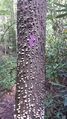
Trail blaze
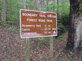
Trail head sign

Park occasionally does "find the Sasquatch" in the park
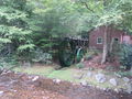
Water wheel at visitor's center


