Boneyard: Difference between revisions
(add lake rd to map) |
(Add banner image choice) |
||
| Line 1: | Line 1: | ||
{{Trail | {{Trail | ||
|Banner Image=File:WPSP Main Split signs.JPG | |||
|Trail System=Warriors' Path State Park Mountain Bike Trails | |Trail System=Warriors' Path State Park Mountain Bike Trails | ||
|Park=Warriors' Path State Park | |Park=Warriors' Path State Park | ||
Revision as of 11:46, 24 June 2023
| Boneyard (log in to submit report) | |
|---|---|

| |
| Trail System | Warriors' Path State Park Mountain Bike Trails |
| Park | Warriors' Path State Park |
| Located | Kingsport, TennesseeLocation inherited from associated park |
| Trail Marking | Black Triangle |
| Trail UseThings allowed to do on or near the trail |
|
| FeaturesThings to see on or near the trail |
|
| Difficulty Rating | Medium |
| Hiking TimeTime from car and back. Includes any time hiking to access this trail. | 1.5 hrs0.0938 Days <br />90 Min <br /> round trip |
| Distance: | 2.408 mi3.875 km <br /> trailStrict non-repeating trail length / 2.92 mi4.699 km <br /> round tripTypical or shortest length from the car, hike the trail, and return to car |
| Trail Type | Segment |
| Low / High Point | 1,275 ft425 Yards <br />388.62 Meters <br /> / 1,487 Ft495.667 Yards <br />453.238 Meters <br /> |
| Elev. Gain/LossSee link for details of calculation. Gain/Loss is direction dependent. | 145 Ft44.196 Meters <br /> / (279 Ft85.039 Meters <br />) – Clockwise |
| Trip ReportsFrom user "hiked it" submissions<br />Recent is within last 90 days | 4 logged hikes (0 recent) |
| NearbyWithin 5 mi<br />Click link to view list | 23 trails / 15.2 mi of trail |
| Parking | 36° 29' 31.67" N, 82° 28' 6.85" W Map |
| Trailhead | 36° 29' 27.13" N, 82° 28' 12.94" W Map |
|
| |
| Show In Google Maps | |
Download KML / Upload new version / KML File Page / Create Profile Chart / gpsvisualizer Map
Trail Overview
Located in Warriors' Path State Park and part of the bike trails system at the park.
How to get there
From main entrance of Warriors Path State Park:
- Go north on Fall Creek Road for 2.4 miles.
- Turn right (east) onto Old Mill Road for 0.8 miles.
- Turn right (south) onto Childress Ferry Road for just roughly 100 yards.
- Turn left (east) onto Buttermilk Road for 1.2 miles.
- Turn right (south) onto Freeman Road for 0.5 mile.
- Continue when road changes from asphalt to gravel.
Trailhead at gravel parking lot.
Route Description

The trail has some decent climbs but none sustained over a long period of time.
A common route is to start at the parking lot and use Lake Road to access Boneyard Connector. This will take you to the true trailhead to the right as it splits with Darwin's Revenge to the left. After the trail completes you will return to the power line cut where it intersects with Pawpaw and Lake Road. Take Lake Road back to the parking lot to complete the loop. This is approximately 3.0 miles (the summary box's "Round Trip Distance").
Typical Conditions
The mountain biking association SORBA Tri-Cities handles the trail maintenance, thus generally in good condition. While there are no blazes to guide you through the forest, the narrow single tracks are well established. Grab a trail map at the parking lot kiosk to help you decipher intersections; some which could use signs. Be aware for approaching bike riders who can come up quickly on your group. Step aside to let them safely pass.
Fees, Permits, etc.
No fee required. Dogs are allowed on or off leash. Do not drink any water without treatment!
Photos

Profile view of Boneyard
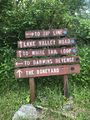
Signs at main trail split