Spivey Gap to Nolichucky River: Difference between revisions
m (added trails template and made section headers) |
(show next trail as well) |
||
| (18 intermediate revisions by 4 users not shown) | |||
| Line 1: | Line 1: | ||
{{Trail | |||
|Banner Image=File:Spivey gap - nolichucky river gorge.jpg | |||
|Trail System=Appalachian Trail | |||
|City=Erwin | |||
|Land Owner=Cherokee National Forest | |||
|Trail Marking=White | |||
|Trail Use=Hiking, Camping | |||
|Trail Features=Vistas, Rivers, Mountains | |||
|Difficulty Rating=Medium | |||
|Hike Time=5 hrs | |||
|Trail Distance=11.2 mi | |||
|Round Trip Distance=22.4 | |||
|Trail Type=In-and-Out | |||
|High Point=3,839 ft | |||
|Low Point=1,683 ft | |||
|Elevation Gain=2,275 ft | |||
|Elevation Loss=3,764 ft | |||
|Elevation Change Direction=South-to-North | |||
|Parking location=36.03198, -82.42029 | |||
|Trailhead location=36.03198, -82.42029 | |||
}} | |||
{{Trail Map|Other Trails=Nolichucky River to Indian Grave Gap}} | |||
__TOC__ | |||
== Trail Overview == | |||
== How to get there == | |||
== Route Description == | |||
(Trail South > North) | (Trail South > North) | ||
== Spivey Gap == | === Spivey Gap === | ||
Spivey Gap (3200') is the southern boundary of the TEHCC's maintenance responsibility and where US19W cross the Trail. South of Spivey Gap, the Trail is maintained by the Carolina Mountain Club. Oglesby Branch, named after TEHCC founder Frank Oglesby, is trail north on Flattop Mountain. | Spivey Gap (3200') is the southern boundary of the TEHCC's maintenance responsibility and where US19W cross the Trail. South of Spivey Gap, the Trail is maintained by the [http://www.carolinamtnclub.org/ Carolina Mountain Club]. Oglesby Branch, named after TEHCC founder Frank Oglesby, is trail north on Flattop Mountain. | ||
== No Business Knob Shelter == | === No Business Knob Shelter === | ||
No Business Knob Shelter (3251') is a concrete block shelter built in 1963 by the United States Forest Service | [[Shelter:No Business Knob|No Business Knob Shelter]] (3251') is a concrete block shelter built in 1963 by the United States Forest Service. | ||
== Cliff Ridge == | === Cliff Ridge === | ||
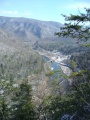
Overlooking the Nolichucky River, Cliff Ridge is the last high point before descending to the Chestoa Bridge crossing of the Nolichucky River. | Overlooking the Nolichucky River, Cliff Ridge is the last high point before descending to the Chestoa Bridge crossing of the Nolichucky River. | ||
== Nolichucky River and Erwin, TN == | === Nolichucky River and Erwin, TN === | ||
The AT meets the Nolichucky River at Chestoa Bridge. Downtown Erwin is approximately 2 miles from this point. Food, resupply, shuttles and lodging are available. | The AT meets the Nolichucky River at Chestoa Bridge. Downtown Erwin is approximately 2 miles from this point. Food, resupply, shuttles and lodging are available. | ||
== Photos == | |||
{{Park trail gallery|Trail={{PAGENAME}}}} | |||
{{Template:AT_Segments}} | {{Template:AT_Segments}} | ||
{{Map Marker | |||
|Icon Type=Point of interest | |||
|Marker Title=Chestoa Bridge | |||
|Marker Location=36.1054571362, -82.447814864 | |||
}} | |||
{{Map Marker | |||
|Icon Type=Summit | |||
|Marker Title=No Business Knob (4,160 ft) | |||
|Marker Location=36.0649000000, -82.443000000 | |||
}} | |||
{{Map Marker | |||
|Icon Type=Shelter | |||
|Marker Title=No Business Knob Shelter | |||
|Marker Location=36.0668799690, -82.433451018 | |||
}} | |||
{{Map Marker | |||
|Icon Type=Summit | |||
|Marker Title=Temple Hill (3,710 ft) | |||
|Marker Location=36.0801000000, -82.460900000 | |||
}} | |||
Latest revision as of 08:16, 21 December 2018
| Spivey Gap to Nolichucky River (log in to submit report) | |
|---|---|

| |
| Trail System | Appalachian Trail |
| Land Owner | Cherokee National Forest |
| Located | Erwin, Tennessee |
| Trail Marking | White |
| Trail UseThings allowed to do on or near the trail |
|
| FeaturesThings to see on or near the trail |
|
| Difficulty Rating | Medium |
| Hiking TimeTime from car and back. Includes any time hiking to access this trail. | 5 hrs0.313 Days <br />300 Min <br /> round trip |
| Distance: | 11.2 mi18.025 km <br /> trailStrict non-repeating trail length / 22.422.4 mi <br />36.049 km <br /> round tripTypical or shortest length from the car, hike the trail, and return to car |
| Trail Type | In-and-Out |
| Low / High Point | 1,683 ft561 Yards <br />512.978 Meters <br /> / 3,839 ft1,279.667 Yards <br />1,170.127 Meters <br /> |
| Elev. Gain/LossSee link for details of calculation. Gain/Loss is direction dependent. | 2,275 ft693.42 Meters <br /> / (3,764 ft1,147.267 Meters <br />) – South-to-North |
| Trip ReportsFrom user "hiked it" submissions<br />Recent is within last 90 days | 1 logged hikes (0 recent) |
| NearbyWithin 5 mi<br />Click link to view list | 1 trails / 7.5 mi of trail |
| Parking | 36° 1' 55.13" N, 82° 25' 13.04" W Map |
| Trailhead | 36° 1' 55.13" N, 82° 25' 13.04" W Map |
|
| |
| Show In Google Maps | |
Download KML / Upload new version / KML File Page / Create Profile Chart / gpsvisualizer Map
Trail Overview[edit]
How to get there[edit]
Route Description[edit]
(Trail South > North)
Spivey Gap[edit]
Spivey Gap (3200') is the southern boundary of the TEHCC's maintenance responsibility and where US19W cross the Trail. South of Spivey Gap, the Trail is maintained by the Carolina Mountain Club. Oglesby Branch, named after TEHCC founder Frank Oglesby, is trail north on Flattop Mountain.
No Business Knob Shelter[edit]
No Business Knob Shelter (3251') is a concrete block shelter built in 1963 by the United States Forest Service.
Cliff Ridge[edit]
Overlooking the Nolichucky River, Cliff Ridge is the last high point before descending to the Chestoa Bridge crossing of the Nolichucky River.
Nolichucky River and Erwin, TN[edit]
The AT meets the Nolichucky River at Chestoa Bridge. Downtown Erwin is approximately 2 miles from this point. Food, resupply, shuttles and lodging are available.
Photos[edit]

White Rhododendron
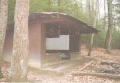
No Business Knob Shelter
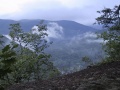
Nolichucky River Gorge
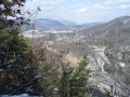
Spivey Gap as viewed from Temple Hill
Spivey Gap as viewed from Temple Hill


