Take Fort Henry to Hemlock Rd. Make the hard left to follow the road on to Fall Creek Rd, go across the bridge. Turn left on Moody and take until it meets Cedar Branch Rd and turn left. The parking area will be on your left as the road makes a hard right.
There are two side tracks that can be taken to get up on to the ridge for some nice views to the south.
The trails are fairly well maintained with boardwalks in the wetter parts and stairs on the steeper parts.
None needed, just park and go.
Blackberries and raspberries abound in late June and July.
Loading map...
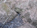
{"type":"TERRAIN","minzoom":false,"maxzoom":false,"types":["ROADMAP","SATELLITE","HYBRID","TERRAIN"],"mappingservice":"googlemaps3","width":"auto","height":"450px","centre":{"text":"","title":"","link":"","lat":36.51432700000000153295331983827054500579833984375,"lon":-82.478398999999996021870174445211887359619140625,"icon":""},"title":"","label":"","icon":"","lines":[],"polygons":[],"circles":[],"rectangles":[],"copycoords":false,"static":false,"visitedicon":"","wmsoverlay":false,"zoom":15,"layers":[],"controls":["pan","zoom","type","scale","streetview","rotate"],"zoomstyle":"DEFAULT","typestyle":"DEFAULT","autoinfowindows":false,"resizable":false,"kmlrezoom":false,"poi":true,"cluster":false,"clustergridsize":60,"clustermaxzoom":20,"clusterzoomonclick":true,"clusteraveragecenter":true,"clusterminsize":2,"imageoverlays":[],"kml":[],"gkml":["http://tehcc.org/clubwiki/kml/WPSP_sinking_water.kml"],"searchmarkers":"","fullscreen":false,"scrollwheelzoom":false,"locations":[{"text":"\u003Cdiv class=\"mw-parser-output\"\u003E\u003Cp\u003EMarker A\n\u003C/p\u003E\u003C/div\u003E","title":"Marker A\n","link":"","lat":36.51659099999999824603946763090789318084716796875,"lon":-82.4736649999999968940755934454500675201416015625,"icon":"/clubwiki/images/MarkerA.png"},{"text":"\u003Cdiv class=\"mw-parser-output\"\u003E\u003Cp\u003E\u003Ca href=\"/wiki/File:Sinking_Waters_sinkhole.jpg\" class=\"image\" title=\"The namesake sinking waters disappearing into a hole\"\u003E\u003Cimg alt=\"The namesake sinking waters disappearing into a hole\" src=\"/clubwiki/images/thumb/Sinking_Waters_sinkhole.jpg/150px-Sinking_Waters_sinkhole.jpg\" decoding=\"async\" width=\"150\" height=\"113\" srcset=\"/clubwiki/images/thumb/Sinking_Waters_sinkhole.jpg/225px-Sinking_Waters_sinkhole.jpg 1.5x, /clubwiki/images/thumb/Sinking_Waters_sinkhole.jpg/300px-Sinking_Waters_sinkhole.jpg 2x\" data-file-width=\"2048\" data-file-height=\"1536\" /\u003E\u003C/a\u003E\u003Cbr /\u003EThe namesake sinking waters\u003Cbr /\u003Edisappearing into a hole\n\u003C/p\u003E\u003C/div\u003E","title":"","link":"","lat":36.51004999999999967030817060731351375579833984375,"lon":-82.4812749999999965666575008071959018707275390625,"icon":"/clubwiki/images/MarkerB.png"},{"text":"\u003Cb\u003E\u003Cdiv class=\"mw-parser-output\"\u003E\u003Cp\u003EUnmarked trail turn\n\u003C/p\u003E\u003C/div\u003E\u003C/b\u003E\u003Cdiv class=\"mw-parser-output\"\u003E\u003Cp\u003EMust turn right uphill or left to follow the creek on your right to continue in the correct direction. Not sure where the other path will take you\n\u003C/p\u003E\u003C/div\u003E","title":"Unmarked trail turn\n","link":"","lat":36.51294500000000198269844986498355865478515625,"lon":-82.4809609999999935325831756927073001861572265625,"icon":"/clubwiki/images/MarkerT.png"}]}