|
|
| Line 2: |
Line 2: |
| {{Infobox Trail | | {{Infobox Trail |
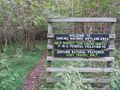
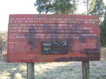
| | Image Name = Sinking Waters information sign.jpg | | | Image Name = Sinking Waters information sign.jpg |
| | | Trail Number = |
| | Park = Warriors Path State Park | | | Park = Warriors Path State Park |
| | City = Kingsport | | | City = Kingsport |
| Line 9: |
Line 10: |
| | Difficulty Rating = Easy | | | Difficulty Rating = Easy |
| | Hike Time = 1 Hour | | | Hike Time = 1 Hour |
| | Round Trip Distance = 1.94 Mi | | | Round Trip Distance = 2.23 Mi |
| | Trail Distance = 1.94 Mi | | | Trail Distance = 2.23 Mi |
| | Trail Type = Loop | | | Trail Type = Loop |
| | Elevation Gain = 645 Ft | | | Elevation Gain = 751 Ft |
| | Elevation Loss = -645 Ft | | | Elevation Loss = -751 Ft |
| | High Point = 1,648 Ft | | | High Point = 1,637 Ft |
| | Parking coords = 36.516591,-82.473665 | | | Parking coords = 36.516591,-82.473665 |
| | Trailhead coords = 36.516591,-82.473665 | | | Trailhead coords = 36.516591,-82.473665 |
| Line 23: |
Line 24: |
| == Trail Overview == | | == Trail Overview == |
| <!-- Enter a overview of the trail. What attracts you to this trail, points of interest, types of flowers, lakes, and peaks that you see along the way. --> | | <!-- Enter a overview of the trail. What attracts you to this trail, points of interest, types of flowers, lakes, and peaks that you see along the way. --> |
| Located in [[Warriors Path State Park]]. Nice quick hike nearby for those in Kingsport. Interesting view of a stream flowing and disappearing into a sink hole (thus the name sinking waters). Can also be made part of a nice jogging route. Also a good location for blackberries and raspberries during the warm summer months. | | Located in [[Warriors Path State Park]]. Nice quick hike nearby for those in Kingsport. Interesting view of a stream flowing and disappearing into a sink hole (thus the name sinking waters). Can also be made part of a nice jogging route. Good views to the south for those that make it to the ridge top, especially on winter early mornings. Also a good location for blackberries and raspberries during the warm summer months. |
|
| |
|
| == How to get there == | | == How to get there == |
| <!-- Please enter detailed instruction on how to find the trail head. --> | | <!-- Please enter detailed instruction on how to find the trail head. --> |
| Take Fort Henry to Hemlock Rd. Make the hard left to follow the road on to Fall Creek Rd, go across the bridge. Turn left on Moody and take until it meets Cedar Branch Rd and turn left. The parking area will be on your left as the road makes a hard right.
| | From the [[Warriors Path State Park#How to get there|park headquarters]]... |
| | # Take Fall Creek Rd across the Holston River. |
| | # Continue past the golf course and turn left on Moody Lane. |
| | # Turn left on to Cedar Branch Rd |
| | # Gravel parking lot on your left as the road turns right |
|
| |
|
| == Route Description== | | == Route Description== |
| <!-- Detailed description of the route. Is there any side trails that are worth traveling? --> | | <!-- Detailed description of the route. Is there any side trails that are worth traveling? --> |
| There are two side tracks that can be taken to get up on to the ridge for some nice views to the south.
| | The trail can be made very short or long by taking the loops as desired. The description below is for an "always turn right" route, (almost always) taking the trail to the right when it splits. |
| | |
| | {| class="wikitable" border="1" |
| | |- |
| | !Miles Out |
| | !{{PAGENAME}} |
| | !Miles Back |
| | !Elevation (ft) |
| | |- |
| | |0.0 |
| | |Trail head |
| | |2.19 |
| | |1,479 |
| | |- |
| | |0.05 |
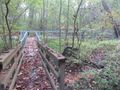
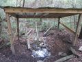
| | |Trail bridge and spring house |
| | |2.14 |
| | |1,457 |
| | |- |
| | |0.1 |
| | |Trail head |
| | |2.09 |
| | |1,494 |
| | |- |
| | |0.3 |
| | |Pass ridge sign and trail high point |
| | |1.89 |
| | |1,637 |
| | |- |
| | |0.5 |
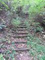
| | |Descend ridge on stairs |
| | |1.69 |
| | |1,499 |
| | |- |
| | |0.54 |
| | |Rejoin lower trail at sign |
| | |1.65 |
| | |1,448 |
| | |- |
| | |0.62 |
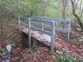
| | |Turn right at bench for 2nd loop |
| | |1.57 |
| | |1,426 |
| | |- |
| | |0.73 |
| | |Bench on upper part of the middle loop |
| | |1.46 |
| | |1,498 |
| | |- |
| | |0.95 |
| | |Trail head |
| | |1.24 |
| | |1,373 |
| | |- |
| | |1.0 |
| | |Bench and sign at paved section and small bridge |
| | |1.19 |
| | |1,382 |
| | |- |
| | |1.09 |
| | |Enter boardwalk section |
| | |1.10 |
| | |1,330 |
| | |- |
| | |1.2 |
| | |Turn right to head to golf course |
| | |0.99 |
| | |1,368 |
| | |- |
| | |1.29 |
| | |Trail head |
| | |0.90 |
| | |1,388 |
| | |- |
| | |1.44 |
| | |View sinking waters |
| | |0.75 |
| | |1,375 |
| | |- |
| | |1.48 |
| | |Leave boardwalk section |
| | |0.71 |
| | |1,479 |
| | |- |
| | |1.6 |
| | |Stay right for middle loop |
| | |0.59 |
| | |1,372 |
| | |- |
| | |1.63 |
| | |Sign about Coffman family |
| | |0.56 |
| | |1,373 |
| | |- |
| | |1.83 |
| | |Complete middle loop |
| | |0.36 |
| | |1,418 |
| | |- |
| | |1.9 |
| | |Begin lower portion of the first loop |
| | |0.29 |
| | |1,443 |
| | |- |
| | |2.1 |
| | |Complete the first loop |
| | |0.09 |
| | |1,499 |
| | |- |
| | |0.0 |
| | |Hike complete |
| | |2.19 |
| | |1,479 |
| | |} |
|
| |
|
| == Typical Conditions == | | == Typical Conditions == |
| <!-- Typical conditions throughout the year of what to expect on the trail. Rocky, muddy, sandy, flowers, lots of downed trees? --> | | <!-- Typical conditions throughout the year of what to expect on the trail. Rocky, muddy, sandy, flowers, lots of downed trees? --> |
| The trails are fairly well maintained with boardwalks in the wetter parts and stairs on the steeper parts. | | The trails are fairly well maintained with boardwalks in the wetter parts and stairs on the steeper parts. Some side trails exist without posted signs. No trail blazes. |
|
| |
|
| ==Fees, Permits, etc. == | | ==Fees, Permits, etc. == |
| <!-- Please list any Fees, Permits, Regulations, etc. that may be required on this trail.--> | | <!-- Please list any Fees, Permits, Regulations, etc. that may be required on this trail.--> |
| None needed, just park and go. | | None needed, just park and go. |
|
| |
| == After the Hike ==
| |
| <!-- Where to get a good meal after a long days hike. Because I know everyone will be hungry!! -->
| |
|
| |
|
| == Misc. Information == | | == Misc. Information == |
| <!-- Enter any additional information that doesn't fit an any other fields. Does this trail require any permits for overnight? parking? --> | | <!-- Enter any additional information that doesn't fit an any other fields. Does this trail require any permits for overnight? parking? --> |
| Blackberries and raspberries abound in late June and July. | | Blackberries and raspberries abound in late June and July. |
| | |
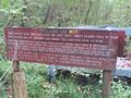
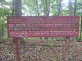
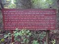
| | According to the signs, the Coffman family settled in the area in the late 1860's. They tried to farm, but frequent floods swept away their cornfield and peach orchard. To get by they switched to blacksmithing and built a shop in the area. |
| | |
| | In recent times the land was owned by (?) who bought it for his daughters to have a spot to ride horses. In (?) he donated to the park. |
|
| |
|
| == Maps == | | == Maps == |
| <!-- You can place pictures, PDF's, links, or even create a Google map with your waypoints and place it here. --> | | <!-- You can place pictures, PDF's, links, or even create a Google map with your waypoints and place it here. --> |
| <display_map center="36.514327,-82.478399" type="terrain" zoom="15" width="auto" height="450" gkml="http://tehcc.org/clubwiki/kml/WPSP_sinking_water.kml"> | | <display_map center="36.514327,-82.478399" type="terrain" zoom="15" width="auto" height="450" gkml="http://tehcc.org/clubwiki/kml/WPSP_sinking_water.kml"> |
| 36.516591,-82.473665~Parking and trail head~ ~MarkerA.png | | 36.516591,-82.473665~Parking and trail head~[[Image:WPSP SW parking lot.jpg|150px|Parking lot sign]]~MarkerA.png |
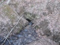
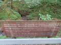
| 36.51005,-82.481275~ ~[[File:Sinking Waters sinkhole.jpg|150px|The namesake sinking waters disappearing into a hole]]<br>The namesake sinking waters<br>disappearing into a hole~MarkerB.png | | 36.51005,-82.481275~ ~[[File:Sinking Waters sinkhole.jpg|150px|The namesake sinking waters disappearing into a hole]]<br>The namesake sinking waters<br>disappearing into a hole~MarkerB.png |
| 36.512945,-82.480961~Unmarked trail turn~Must turn right uphill or left to follow the creek on your right to continue in the correct direction. Not sure where the other path will take you~MarkerT.png | | 36.512945,-82.480961~Unmarked trail turn~Must turn right uphill or left to follow the creek on your right to continue in the correct direction. Not sure where the other path will take you~MarkerT.png |
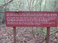
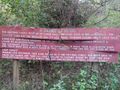
| | 36.515965,-82.477991~Trail sign~[[Image:WPSP SW sign on NorthEast loop.jpg|150px|Sign on ridge of the first loop]]~MarkerG.png |
| | 36.514836,-82.477365~Trail stairs~[[Image:WPSP SW stairs.jpg|150px|Stairs coming off of the ridge]]~MarkerG.png |
| | 36.514300,-82.476834~Trail sign~[[Image:WPSP SW trail sign near stairs.jpg|150px|Sign near stairs of 1st loop rejoining]]~MarkerG.png |
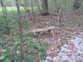
| | 36.513507,-82.477734~Bench~[[Image:WPSP SW bench at 2nd loop split.jpg|150px|Bench]]~MarkerK.png |
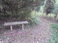
| | 36.513756,-82.479150~Bench~[[Image:WPSP SW bench on North middle loop.jpg|150px|Bench on North leg of 2nd loop]]~MarkerK.png |
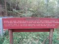
| | 36.512311,-82.479665~Trail sign~[[Image:WPSP SW Sign on South mid loop.jpg|150px|Sign on south end of the middle loop]]~MarkerG.png |
| | 36.511608,-82.480456~Trail sign~[[Image:WPSP SW sign at mid loop rejoin.jpg|150px|Sign between 2nd and 3rd loop/boardwalk]]~MarkerG.png |
| | 36.511634,-82.480276~Bench~[[Image:WPSP SW bench at paved portion.jpg|150px|Bench between 2nd loop and boardwalk]]~MarkerK.png |
| | 36.510686,-82.481056~Trail signs~[[Image:WPSP SW boardwalk sign front.jpg|150px|Front side of boardwalk sign]]<br>[[Image:WPSP SW Boardwalk sign back.jpg|150px|Back side of boardwalk sign]]~MarkerG.png |
| | 36.509158,-82.481430~Trail sign~[[Image:WPSP SW Golf Course Entrance.jpg|150px|Golf Course Entrance sign]]~MarkerG.png |
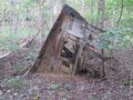
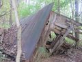
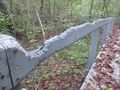
| | 36.508427,-82.481489~Collapsed shed~[[Image:WPSP SW Collapsed shed 1.jpg|150px|Collapsed shed]]~MarkerV.png |
| | 36.508385,-82.481618~Structure remains~ ~MarkerV.png |
| | 36.516404,-82.474316~Water bridge~[[Image:WPSP SW bridge.jpg|150px|Bridge near parking]]~MarkerL.png |
| | 36.515910,-82.475133~Trail sign~[[Image:WPSP SW Sign on SouthEast Loop.jpg|150px|Sign on south end of the first loop]]~MarkerG.png |
| | 36.516526,-82.474229~Spring house~[[Image:WPSP SW spring house.jpg|150px|Spring house]]~MarkerG.png |
| </display_map> | | </display_map> |
|
| |
|
| Line 60: |
Line 194: |
| <!-- Place any pictures from this trail below. Add a picture by typing Image:imagename.extension --> | | <!-- Place any pictures from this trail below. Add a picture by typing Image:imagename.extension --> |
| Image:Sinking Waters sinkhole.jpg|The namesake sinking waters disappearing into a hole | | Image:Sinking Waters sinkhole.jpg|The namesake sinking waters disappearing into a hole |
| | | Image:WPSP SW bench at paved portion.jpg|Bench between 2nd loop and boardwalk |
| | Image:WPSP SW bench at 2nd loop split.jpg|Bench at 2nd loop split |
| | Image:WPSP SW bench on North middle loop.jpg|Bench on North leg of 2nd loop |
| | Image:WPSP SW Boardwalk sign back.jpg|Back side of boardwalk sign |
| | Image:WPSP SW boardwalk sign front.jpg|Front side of boardwalk sign |
| | Image:WPSP SW Boardwalk.jpg|Boardwalk |
| | Image:WPSP SW bridge.jpg|Bridge near parking |
| | Image:WPSP SW Collapsed shed 1.jpg|Collapsed shed |
| | Image:WPSP SW Collapsed shed 2.jpg|Collapsed shed |
| | Image:WPSP SW Golf Course Entrance.jpg|Golf Course Entrance sign |
| | Image:WPSP SW parking lot.jpg|Parking lot sign |
| | Image:WPSP SW sign at mid loop rejoin.jpg|Sign between 2nd and 3rd loop/boardwalk |
| | Image:WPSP SW sign at sink hole.jpg|Sinking waters sign |
| | Image:WPSP SW sign on NorthEast loop.jpg|Sign on ridge of the first loop |
| | Image:WPSP SW Sign on South mid loop.jpg|Sign on south end of the middle loop |
| | Image:WPSP SW Sign on SouthEast Loop.jpg|Sign on south end of the first loop |
| | Image:WPSP SW spring house.jpg|Spring house |
| | Image:WPSP SW Squirrel Attack 1.jpg|Squirrels attracted to synthetic decking |
| | Image:WPSP SW stairs.jpg|Stairs coming off of the ridge |
| | Image:WPSP SW trail sign near stairs.jpg|Sign near stairs of 1st loop rejoining |
| <!-- Do not remove the end gallery code.--> | | <!-- Do not remove the end gallery code.--> |
| </gallery> | | </gallery> |
| Line 66: |
Line 219: |
| <!-- Finally add the trail to any Categories it should belong to. Please keep the State category. To make a new category just type [[Category:mycategory]]. Keep in mind categories are case sensitive. --> | | <!-- Finally add the trail to any Categories it should belong to. Please keep the State category. To make a new category just type [[Category:mycategory]]. Keep in mind categories are case sensitive. --> |
| [[Category:Tennessee]] [[Category:Warriors Path State Park]] [[Category:Kingsport]] [[Category:Dog Friendly]] [[Category:Easy]] | | [[Category:Tennessee]] [[Category:Warriors Path State Park]] [[Category:Kingsport]] [[Category:Dog Friendly]] [[Category:Easy]] |
| | {{#set: |
| | |Trail page needs=Winter photos;Update 1|+sep=; |
| | }} |
|
|
|
|
|
| Trail Name
|
Sinking Waters
|
| Park
|
Warriors Path State Park
|
| Nearest City
|
Kingsport
|
| State
|
Tennessee
|
| Trail Marking
|
None
|
| Trail Use/Features
|
  
|
| Difficulty Rating
|
Easy
|
| Hiking Time
|
1 Hour0.0625 Days <br />60 Min <br />
|
Distance:
round-trip/trail only
|
2.23 Mi3.589 km <br /> / 2.23 Mi3.589 km <br />
|
| Trail Type
|
Loop
|
| Climb/Descent Elevation
|
751 Ft228.905 Meters <br /> / -751 Ft-228.905 Meters <br />
|
| High Point
|
1,637 Ft545.667 Yards <br />498.958 Meters <br />
|
| Parking
|
36° 30' 59.73" N, 82° 28' 25.19" W
|
| Trailhead
|
36° 30' 59.73" N, 82° 28' 25.19" W
|
| Nearest Medical
|
Indian Path Hospital
|
| Trip Reports
|
Click Here
|
|
|
Loading map... {"type":"ROADMAP","minzoom":false,"maxzoom":false,"types":["ROADMAP","SATELLITE","HYBRID","TERRAIN"],"mappingservice":"googlemaps3","width":"270px","height":"180px","centre":false,"title":"","label":"","icon":"","lines":[],"polygons":[],"circles":[],"rectangles":[],"copycoords":false,"static":false,"visitedicon":"","wmsoverlay":false,"zoom":8,"layers":[],"controls":["zoom"],"zoomstyle":"DEFAULT","typestyle":"DEFAULT","autoinfowindows":false,"resizable":false,"kmlrezoom":false,"poi":true,"cluster":false,"clustergridsize":60,"clustermaxzoom":20,"clusterzoomonclick":true,"clusteraveragecenter":true,"clusterminsize":2,"imageoverlays":[],"kml":[],"gkml":[],"searchmarkers":"","fullscreen":false,"scrollwheelzoom":false,"locations":[{"text":"","title":"","link":"","lat":36.51659099999999824603946763090789318084716796875,"lon":-82.4736649999999968940755934454500675201416015625,"icon":""}]} |
|
| Show Large Map
|
|
Trail Overview
Located in Warriors Path State Park. Nice quick hike nearby for those in Kingsport. Interesting view of a stream flowing and disappearing into a sink hole (thus the name sinking waters). Can also be made part of a nice jogging route. Good views to the south for those that make it to the ridge top, especially on winter early mornings. Also a good location for blackberries and raspberries during the warm summer months.
How to get there
From the park headquarters...
- Take Fall Creek Rd across the Holston River.
- Continue past the golf course and turn left on Moody Lane.
- Turn left on to Cedar Branch Rd
- Gravel parking lot on your left as the road turns right
Route Description
The trail can be made very short or long by taking the loops as desired. The description below is for an "always turn right" route, (almost always) taking the trail to the right when it splits.
| Miles Out
|
Sinking Waters
|
Miles Back
|
Elevation (ft)
|
| 0.0
|
Trail head
|
2.19
|
1,479
|
| 0.05
|
Trail bridge and spring house
|
2.14
|
1,457
|
| 0.1
|
Trail head
|
2.09
|
1,494
|
| 0.3
|
Pass ridge sign and trail high point
|
1.89
|
1,637
|
| 0.5
|
Descend ridge on stairs
|
1.69
|
1,499
|
| 0.54
|
Rejoin lower trail at sign
|
1.65
|
1,448
|
| 0.62
|
Turn right at bench for 2nd loop
|
1.57
|
1,426
|
| 0.73
|
Bench on upper part of the middle loop
|
1.46
|
1,498
|
| 0.95
|
Trail head
|
1.24
|
1,373
|
| 1.0
|
Bench and sign at paved section and small bridge
|
1.19
|
1,382
|
| 1.09
|
Enter boardwalk section
|
1.10
|
1,330
|
| 1.2
|
Turn right to head to golf course
|
0.99
|
1,368
|
| 1.29
|
Trail head
|
0.90
|
1,388
|
| 1.44
|
View sinking waters
|
0.75
|
1,375
|
| 1.48
|
Leave boardwalk section
|
0.71
|
1,479
|
| 1.6
|
Stay right for middle loop
|
0.59
|
1,372
|
| 1.63
|
Sign about Coffman family
|
0.56
|
1,373
|
| 1.83
|
Complete middle loop
|
0.36
|
1,418
|
| 1.9
|
Begin lower portion of the first loop
|
0.29
|
1,443
|
| 2.1
|
Complete the first loop
|
0.09
|
1,499
|
| 0.0
|
Hike complete
|
2.19
|
1,479
|
Typical Conditions
The trails are fairly well maintained with boardwalks in the wetter parts and stairs on the steeper parts. Some side trails exist without posted signs. No trail blazes.
Fees, Permits, etc.
None needed, just park and go.
Misc. Information
Blackberries and raspberries abound in late June and July.
According to the signs, the Coffman family settled in the area in the late 1860's. They tried to farm, but frequent floods swept away their cornfield and peach orchard. To get by they switched to blacksmithing and built a shop in the area.
In recent times the land was owned by (?) who bought it for his daughters to have a spot to ride horses. In (?) he donated to the park.
Maps
Loading map...
{"type":"TERRAIN","minzoom":false,"maxzoom":false,"types":["ROADMAP","SATELLITE","HYBRID","TERRAIN"],"mappingservice":"googlemaps3","width":"auto","height":"450px","centre":{"text":"","title":"","link":"","lat":36.51432700000000153295331983827054500579833984375,"lon":-82.478398999999996021870174445211887359619140625,"icon":""},"title":"","label":"","icon":"","lines":[],"polygons":[],"circles":[],"rectangles":[],"copycoords":false,"static":false,"visitedicon":"","wmsoverlay":false,"zoom":15,"layers":[],"controls":["pan","zoom","type","scale","streetview","rotate"],"zoomstyle":"DEFAULT","typestyle":"DEFAULT","autoinfowindows":false,"resizable":false,"kmlrezoom":false,"poi":true,"cluster":false,"clustergridsize":60,"clustermaxzoom":20,"clusterzoomonclick":true,"clusteraveragecenter":true,"clusterminsize":2,"imageoverlays":[],"kml":[],"gkml":["http://tehcc.org/clubwiki/kml/WPSP_sinking_water.kml"],"searchmarkers":"","fullscreen":false,"scrollwheelzoom":false,"locations":[{"text":"\u003Cb\u003E\u003Cdiv class=\"mw-parser-output\"\u003E\u003Cp\u003EParking and trail head\n\u003C/p\u003E\u003C/div\u003E\u003C/b\u003E\u003Cdiv class=\"mw-parser-output\"\u003E\u003Cp\u003E\u003Ca href=\"/wiki/File:WPSP_SW_parking_lot.jpg\" class=\"image\" title=\"Parking lot sign\"\u003E\u003Cimg alt=\"Parking lot sign\" src=\"/clubwiki/images/thumb/WPSP_SW_parking_lot.jpg/150px-WPSP_SW_parking_lot.jpg\" decoding=\"async\" width=\"150\" height=\"83\" srcset=\"/clubwiki/images/thumb/WPSP_SW_parking_lot.jpg/225px-WPSP_SW_parking_lot.jpg 1.5x, /clubwiki/images/thumb/WPSP_SW_parking_lot.jpg/300px-WPSP_SW_parking_lot.jpg 2x\" data-file-width=\"1280\" data-file-height=\"705\" /\u003E\u003C/a\u003E\n\u003C/p\u003E\u003C/div\u003E","title":"Parking and trail head\n","link":"","lat":36.51659099999999824603946763090789318084716796875,"lon":-82.4736649999999968940755934454500675201416015625,"icon":"/clubwiki/images/MarkerA.png"},{"text":"\u003Cdiv class=\"mw-parser-output\"\u003E\u003Cp\u003E\u003Ca href=\"/wiki/File:Sinking_Waters_sinkhole.jpg\" class=\"image\" title=\"The namesake sinking waters disappearing into a hole\"\u003E\u003Cimg alt=\"The namesake sinking waters disappearing into a hole\" src=\"/clubwiki/images/thumb/Sinking_Waters_sinkhole.jpg/150px-Sinking_Waters_sinkhole.jpg\" decoding=\"async\" width=\"150\" height=\"113\" srcset=\"/clubwiki/images/thumb/Sinking_Waters_sinkhole.jpg/225px-Sinking_Waters_sinkhole.jpg 1.5x, /clubwiki/images/thumb/Sinking_Waters_sinkhole.jpg/300px-Sinking_Waters_sinkhole.jpg 2x\" data-file-width=\"2048\" data-file-height=\"1536\" /\u003E\u003C/a\u003E\u003Cbr /\u003EThe namesake sinking waters\u003Cbr /\u003Edisappearing into a hole\n\u003C/p\u003E\u003C/div\u003E","title":"","link":"","lat":36.51004999999999967030817060731351375579833984375,"lon":-82.4812749999999965666575008071959018707275390625,"icon":"/clubwiki/images/MarkerB.png"},{"text":"\u003Cb\u003E\u003Cdiv class=\"mw-parser-output\"\u003E\u003Cp\u003EUnmarked trail turn\n\u003C/p\u003E\u003C/div\u003E\u003C/b\u003E\u003Cdiv class=\"mw-parser-output\"\u003E\u003Cp\u003EMust turn right uphill or left to follow the creek on your right to continue in the correct direction. Not sure where the other path will take you\n\u003C/p\u003E\u003C/div\u003E","title":"Unmarked trail turn\n","link":"","lat":36.51294500000000198269844986498355865478515625,"lon":-82.4809609999999935325831756927073001861572265625,"icon":"/clubwiki/images/MarkerT.png"},{"text":"\u003Cb\u003E\u003Cdiv class=\"mw-parser-output\"\u003E\u003Cp\u003ETrail sign\n\u003C/p\u003E\u003C/div\u003E\u003C/b\u003E\u003Cdiv class=\"mw-parser-output\"\u003E\u003Cp\u003E\u003Ca href=\"/wiki/File:WPSP_SW_sign_on_NorthEast_loop.jpg\" class=\"image\" title=\"Sign on ridge of the first loop\"\u003E\u003Cimg alt=\"Sign on ridge of the first loop\" src=\"/clubwiki/images/thumb/WPSP_SW_sign_on_NorthEast_loop.jpg/150px-WPSP_SW_sign_on_NorthEast_loop.jpg\" decoding=\"async\" width=\"150\" height=\"113\" srcset=\"/clubwiki/images/thumb/WPSP_SW_sign_on_NorthEast_loop.jpg/225px-WPSP_SW_sign_on_NorthEast_loop.jpg 1.5x, /clubwiki/images/thumb/WPSP_SW_sign_on_NorthEast_loop.jpg/300px-WPSP_SW_sign_on_NorthEast_loop.jpg 2x\" data-file-width=\"1280\" data-file-height=\"960\" /\u003E\u003C/a\u003E\n\u003C/p\u003E\u003C/div\u003E","title":"Trail sign\n","link":"","lat":36.51596500000000133923094836063683032989501953125,"lon":-82.477991000000002941305865533649921417236328125,"icon":"/clubwiki/images/MarkerG.png"},{"text":"\u003Cb\u003E\u003Cdiv class=\"mw-parser-output\"\u003E\u003Cp\u003ETrail stairs\n\u003C/p\u003E\u003C/div\u003E\u003C/b\u003E\u003Cdiv class=\"mw-parser-output\"\u003E\u003Cp\u003E\u003Ca href=\"/wiki/File:WPSP_SW_stairs.jpg\" class=\"image\" title=\"Stairs coming off of the ridge\"\u003E\u003Cimg alt=\"Stairs coming off of the ridge\" src=\"/clubwiki/images/thumb/WPSP_SW_stairs.jpg/150px-WPSP_SW_stairs.jpg\" decoding=\"async\" width=\"150\" height=\"200\" srcset=\"/clubwiki/images/thumb/WPSP_SW_stairs.jpg/225px-WPSP_SW_stairs.jpg 1.5x, /clubwiki/images/thumb/WPSP_SW_stairs.jpg/300px-WPSP_SW_stairs.jpg 2x\" data-file-width=\"768\" data-file-height=\"1024\" /\u003E\u003C/a\u003E\n\u003C/p\u003E\u003C/div\u003E","title":"Trail stairs\n","link":"","lat":36.51483600000000251384335570037364959716796875,"lon":-82.4773650000000060344973462633788585662841796875,"icon":"/clubwiki/images/MarkerG.png"},{"text":"\u003Cb\u003E\u003Cdiv class=\"mw-parser-output\"\u003E\u003Cp\u003ETrail sign\n\u003C/p\u003E\u003C/div\u003E\u003C/b\u003E\u003Cdiv class=\"mw-parser-output\"\u003E\u003Cp\u003E\u003Ca href=\"/wiki/File:WPSP_SW_trail_sign_near_stairs.jpg\" class=\"image\" title=\"Sign near stairs of 1st loop rejoining\"\u003E\u003Cimg alt=\"Sign near stairs of 1st loop rejoining\" src=\"/clubwiki/images/thumb/WPSP_SW_trail_sign_near_stairs.jpg/150px-WPSP_SW_trail_sign_near_stairs.jpg\" decoding=\"async\" width=\"150\" height=\"113\" srcset=\"/clubwiki/images/thumb/WPSP_SW_trail_sign_near_stairs.jpg/225px-WPSP_SW_trail_sign_near_stairs.jpg 1.5x, /clubwiki/images/thumb/WPSP_SW_trail_sign_near_stairs.jpg/300px-WPSP_SW_trail_sign_near_stairs.jpg 2x\" data-file-width=\"1280\" data-file-height=\"960\" /\u003E\u003C/a\u003E\n\u003C/p\u003E\u003C/div\u003E","title":"Trail sign\n","link":"","lat":36.51429999999999864712663111276924610137939453125,"lon":-82.47683399999999664942151866853237152099609375,"icon":"/clubwiki/images/MarkerG.png"},{"text":"\u003Cb\u003E\u003Cdiv class=\"mw-parser-output\"\u003E\u003Cp\u003EBench\n\u003C/p\u003E\u003C/div\u003E\u003C/b\u003E\u003Cdiv class=\"mw-parser-output\"\u003E\u003Cp\u003E\u003Ca href=\"/wiki/File:WPSP_SW_bench_at_2nd_loop_split.jpg\" class=\"image\" title=\"Bench\"\u003E\u003Cimg alt=\"Bench\" src=\"/clubwiki/images/thumb/WPSP_SW_bench_at_2nd_loop_split.jpg/150px-WPSP_SW_bench_at_2nd_loop_split.jpg\" decoding=\"async\" width=\"150\" height=\"113\" srcset=\"/clubwiki/images/thumb/WPSP_SW_bench_at_2nd_loop_split.jpg/225px-WPSP_SW_bench_at_2nd_loop_split.jpg 1.5x, /clubwiki/images/thumb/WPSP_SW_bench_at_2nd_loop_split.jpg/300px-WPSP_SW_bench_at_2nd_loop_split.jpg 2x\" data-file-width=\"1280\" data-file-height=\"960\" /\u003E\u003C/a\u003E\n\u003C/p\u003E\u003C/div\u003E","title":"Bench\n","link":"","lat":36.51350699999999704914444009773433208465576171875,"lon":-82.47773399999999810461304150521755218505859375,"icon":"/clubwiki/images/MarkerK.png"},{"text":"\u003Cb\u003E\u003Cdiv class=\"mw-parser-output\"\u003E\u003Cp\u003EBench\n\u003C/p\u003E\u003C/div\u003E\u003C/b\u003E\u003Cdiv class=\"mw-parser-output\"\u003E\u003Cp\u003E\u003Ca href=\"/wiki/File:WPSP_SW_bench_on_North_middle_loop.jpg\" class=\"image\" title=\"Bench on North leg of 2nd loop\"\u003E\u003Cimg alt=\"Bench on North leg of 2nd loop\" src=\"/clubwiki/images/thumb/WPSP_SW_bench_on_North_middle_loop.jpg/150px-WPSP_SW_bench_on_North_middle_loop.jpg\" decoding=\"async\" width=\"150\" height=\"113\" srcset=\"/clubwiki/images/thumb/WPSP_SW_bench_on_North_middle_loop.jpg/225px-WPSP_SW_bench_on_North_middle_loop.jpg 1.5x, /clubwiki/images/thumb/WPSP_SW_bench_on_North_middle_loop.jpg/300px-WPSP_SW_bench_on_North_middle_loop.jpg 2x\" data-file-width=\"1280\" data-file-height=\"960\" /\u003E\u003C/a\u003E\n\u003C/p\u003E\u003C/div\u003E","title":"Bench\n","link":"","lat":36.51375600000000076761352829635143280029296875,"lon":-82.4791500000000041836756281554698944091796875,"icon":"/clubwiki/images/MarkerK.png"},{"text":"\u003Cb\u003E\u003Cdiv class=\"mw-parser-output\"\u003E\u003Cp\u003ETrail sign\n\u003C/p\u003E\u003C/div\u003E\u003C/b\u003E\u003Cdiv class=\"mw-parser-output\"\u003E\u003Cp\u003E\u003Ca href=\"/wiki/File:WPSP_SW_Sign_on_South_mid_loop.jpg\" class=\"image\" title=\"Sign on south end of the middle loop\"\u003E\u003Cimg alt=\"Sign on south end of the middle loop\" src=\"/clubwiki/images/thumb/WPSP_SW_Sign_on_South_mid_loop.jpg/150px-WPSP_SW_Sign_on_South_mid_loop.jpg\" decoding=\"async\" width=\"150\" height=\"113\" srcset=\"/clubwiki/images/thumb/WPSP_SW_Sign_on_South_mid_loop.jpg/225px-WPSP_SW_Sign_on_South_mid_loop.jpg 1.5x, /clubwiki/images/thumb/WPSP_SW_Sign_on_South_mid_loop.jpg/300px-WPSP_SW_Sign_on_South_mid_loop.jpg 2x\" data-file-width=\"1280\" data-file-height=\"960\" /\u003E\u003C/a\u003E\n\u003C/p\u003E\u003C/div\u003E","title":"Trail sign\n","link":"","lat":36.5123109999999968522388371638953685760498046875,"lon":-82.4796649999999971214492688886821269989013671875,"icon":"/clubwiki/images/MarkerG.png"},{"text":"\u003Cb\u003E\u003Cdiv class=\"mw-parser-output\"\u003E\u003Cp\u003ETrail sign\n\u003C/p\u003E\u003C/div\u003E\u003C/b\u003E\u003Cdiv class=\"mw-parser-output\"\u003E\u003Cp\u003E\u003Ca href=\"/wiki/File:WPSP_SW_sign_at_mid_loop_rejoin.jpg\" class=\"image\" title=\"Sign between 2nd and 3rd loop/boardwalk\"\u003E\u003Cimg alt=\"Sign between 2nd and 3rd loop/boardwalk\" src=\"/clubwiki/images/thumb/WPSP_SW_sign_at_mid_loop_rejoin.jpg/150px-WPSP_SW_sign_at_mid_loop_rejoin.jpg\" decoding=\"async\" width=\"150\" height=\"113\" srcset=\"/clubwiki/images/thumb/WPSP_SW_sign_at_mid_loop_rejoin.jpg/225px-WPSP_SW_sign_at_mid_loop_rejoin.jpg 1.5x, /clubwiki/images/thumb/WPSP_SW_sign_at_mid_loop_rejoin.jpg/300px-WPSP_SW_sign_at_mid_loop_rejoin.jpg 2x\" data-file-width=\"1280\" data-file-height=\"960\" /\u003E\u003C/a\u003E\n\u003C/p\u003E\u003C/div\u003E","title":"Trail sign\n","link":"","lat":36.51160800000000250520315603353083133697509765625,"lon":-82.480456000000003768946044147014617919921875,"icon":"/clubwiki/images/MarkerG.png"},{"text":"\u003Cb\u003E\u003Cdiv class=\"mw-parser-output\"\u003E\u003Cp\u003EBench\n\u003C/p\u003E\u003C/div\u003E\u003C/b\u003E\u003Cdiv class=\"mw-parser-output\"\u003E\u003Cp\u003E\u003Ca href=\"/wiki/File:WPSP_SW_bench_at_paved_portion.jpg\" class=\"image\" title=\"Bench between 2nd loop and boardwalk\"\u003E\u003Cimg alt=\"Bench between 2nd loop and boardwalk\" src=\"/clubwiki/images/thumb/WPSP_SW_bench_at_paved_portion.jpg/150px-WPSP_SW_bench_at_paved_portion.jpg\" decoding=\"async\" width=\"150\" height=\"113\" srcset=\"/clubwiki/images/thumb/WPSP_SW_bench_at_paved_portion.jpg/225px-WPSP_SW_bench_at_paved_portion.jpg 1.5x, /clubwiki/images/thumb/WPSP_SW_bench_at_paved_portion.jpg/300px-WPSP_SW_bench_at_paved_portion.jpg 2x\" data-file-width=\"1280\" data-file-height=\"960\" /\u003E\u003C/a\u003E\n\u003C/p\u003E\u003C/div\u003E","title":"Bench\n","link":"","lat":36.5116340000000008103597792796790599822998046875,"lon":-82.480276000000003477907739579677581787109375,"icon":"/clubwiki/images/MarkerK.png"},{"text":"\u003Cb\u003E\u003Cdiv class=\"mw-parser-output\"\u003E\u003Cp\u003ETrail signs\n\u003C/p\u003E\u003C/div\u003E\u003C/b\u003E\u003Cdiv class=\"mw-parser-output\"\u003E\u003Cp\u003E\u003Ca href=\"/wiki/File:WPSP_SW_boardwalk_sign_front.jpg\" class=\"image\" title=\"Front side of boardwalk sign\"\u003E\u003Cimg alt=\"Front side of boardwalk sign\" src=\"/clubwiki/images/thumb/WPSP_SW_boardwalk_sign_front.jpg/150px-WPSP_SW_boardwalk_sign_front.jpg\" decoding=\"async\" width=\"150\" height=\"113\" srcset=\"/clubwiki/images/thumb/WPSP_SW_boardwalk_sign_front.jpg/225px-WPSP_SW_boardwalk_sign_front.jpg 1.5x, /clubwiki/images/thumb/WPSP_SW_boardwalk_sign_front.jpg/300px-WPSP_SW_boardwalk_sign_front.jpg 2x\" data-file-width=\"1280\" data-file-height=\"960\" /\u003E\u003C/a\u003E\u003Cbr /\u003E\u003Ca href=\"/wiki/File:WPSP_SW_Boardwalk_sign_back.jpg\" class=\"image\" title=\"Back side of boardwalk sign\"\u003E\u003Cimg alt=\"Back side of boardwalk sign\" src=\"/clubwiki/images/thumb/WPSP_SW_Boardwalk_sign_back.jpg/150px-WPSP_SW_Boardwalk_sign_back.jpg\" decoding=\"async\" width=\"150\" height=\"113\" srcset=\"/clubwiki/images/thumb/WPSP_SW_Boardwalk_sign_back.jpg/225px-WPSP_SW_Boardwalk_sign_back.jpg 1.5x, /clubwiki/images/thumb/WPSP_SW_Boardwalk_sign_back.jpg/300px-WPSP_SW_Boardwalk_sign_back.jpg 2x\" data-file-width=\"1280\" data-file-height=\"960\" /\u003E\u003C/a\u003E\n\u003C/p\u003E\u003C/div\u003E","title":"Trail signs\n","link":"","lat":36.51068599999999975125319906510412693023681640625,"lon":-82.481055999999995265170582570135593414306640625,"icon":"/clubwiki/images/MarkerG.png"},{"text":"\u003Cb\u003E\u003Cdiv class=\"mw-parser-output\"\u003E\u003Cp\u003ETrail sign\n\u003C/p\u003E\u003C/div\u003E\u003C/b\u003E\u003Cdiv class=\"mw-parser-output\"\u003E\u003Cp\u003E\u003Ca href=\"/wiki/File:WPSP_SW_Golf_Course_Entrance.jpg\" class=\"image\" title=\"Golf Course Entrance sign\"\u003E\u003Cimg alt=\"Golf Course Entrance sign\" src=\"/clubwiki/images/thumb/WPSP_SW_Golf_Course_Entrance.jpg/150px-WPSP_SW_Golf_Course_Entrance.jpg\" decoding=\"async\" width=\"150\" height=\"113\" srcset=\"/clubwiki/images/thumb/WPSP_SW_Golf_Course_Entrance.jpg/225px-WPSP_SW_Golf_Course_Entrance.jpg 1.5x, /clubwiki/images/thumb/WPSP_SW_Golf_Course_Entrance.jpg/300px-WPSP_SW_Golf_Course_Entrance.jpg 2x\" data-file-width=\"1280\" data-file-height=\"960\" /\u003E\u003C/a\u003E\n\u003C/p\u003E\u003C/div\u003E","title":"Trail sign\n","link":"","lat":36.5091579999999993333403836004436016082763671875,"lon":-82.4814300000000031332092476077377796173095703125,"icon":"/clubwiki/images/MarkerG.png"},{"text":"\u003Cb\u003E\u003Cdiv class=\"mw-parser-output\"\u003E\u003Cp\u003ECollapsed shed\n\u003C/p\u003E\u003C/div\u003E\u003C/b\u003E\u003Cdiv class=\"mw-parser-output\"\u003E\u003Cp\u003E\u003Ca href=\"/wiki/File:WPSP_SW_Collapsed_shed_1.jpg\" class=\"image\" title=\"Collapsed shed\"\u003E\u003Cimg alt=\"Collapsed shed\" src=\"/clubwiki/images/thumb/WPSP_SW_Collapsed_shed_1.jpg/150px-WPSP_SW_Collapsed_shed_1.jpg\" decoding=\"async\" width=\"150\" height=\"113\" srcset=\"/clubwiki/images/thumb/WPSP_SW_Collapsed_shed_1.jpg/225px-WPSP_SW_Collapsed_shed_1.jpg 1.5x, /clubwiki/images/thumb/WPSP_SW_Collapsed_shed_1.jpg/300px-WPSP_SW_Collapsed_shed_1.jpg 2x\" data-file-width=\"1280\" data-file-height=\"960\" /\u003E\u003C/a\u003E\n\u003C/p\u003E\u003C/div\u003E","title":"Collapsed shed\n","link":"","lat":36.5084269999999975198079482652246952056884765625,"lon":-82.4814889999999962810761644504964351654052734375,"icon":"/clubwiki/images/MarkerV.png"},{"text":"\u003Cdiv class=\"mw-parser-output\"\u003E\u003Cp\u003EStructure remains\n\u003C/p\u003E\u003C/div\u003E","title":"Structure remains\n","link":"","lat":36.50838499999999697820385335944592952728271484375,"lon":-82.481617999999997437043930403888225555419921875,"icon":"/clubwiki/images/MarkerV.png"},{"text":"\u003Cb\u003E\u003Cdiv class=\"mw-parser-output\"\u003E\u003Cp\u003EWater bridge\n\u003C/p\u003E\u003C/div\u003E\u003C/b\u003E\u003Cdiv class=\"mw-parser-output\"\u003E\u003Cp\u003E\u003Ca href=\"/wiki/File:WPSP_SW_bridge.jpg\" class=\"image\" title=\"Bridge near parking\"\u003E\u003Cimg alt=\"Bridge near parking\" src=\"/clubwiki/images/thumb/WPSP_SW_bridge.jpg/150px-WPSP_SW_bridge.jpg\" decoding=\"async\" width=\"150\" height=\"113\" srcset=\"/clubwiki/images/thumb/WPSP_SW_bridge.jpg/225px-WPSP_SW_bridge.jpg 1.5x, /clubwiki/images/thumb/WPSP_SW_bridge.jpg/300px-WPSP_SW_bridge.jpg 2x\" data-file-width=\"1280\" data-file-height=\"960\" /\u003E\u003C/a\u003E\n\u003C/p\u003E\u003C/div\u003E","title":"Water bridge\n","link":"","lat":36.51640400000000141744749271310865879058837890625,"lon":-82.4743160000000017362253856845200061798095703125,"icon":"/clubwiki/images/MarkerL.png"},{"text":"\u003Cb\u003E\u003Cdiv class=\"mw-parser-output\"\u003E\u003Cp\u003ETrail sign\n\u003C/p\u003E\u003C/div\u003E\u003C/b\u003E\u003Cdiv class=\"mw-parser-output\"\u003E\u003Cp\u003E\u003Ca href=\"/wiki/File:WPSP_SW_Sign_on_SouthEast_Loop.jpg\" class=\"image\" title=\"Sign on south end of the first loop\"\u003E\u003Cimg alt=\"Sign on south end of the first loop\" src=\"/clubwiki/images/thumb/WPSP_SW_Sign_on_SouthEast_Loop.jpg/150px-WPSP_SW_Sign_on_SouthEast_Loop.jpg\" decoding=\"async\" width=\"150\" height=\"113\" srcset=\"/clubwiki/images/thumb/WPSP_SW_Sign_on_SouthEast_Loop.jpg/225px-WPSP_SW_Sign_on_SouthEast_Loop.jpg 1.5x, /clubwiki/images/thumb/WPSP_SW_Sign_on_SouthEast_Loop.jpg/300px-WPSP_SW_Sign_on_SouthEast_Loop.jpg 2x\" data-file-width=\"1280\" data-file-height=\"960\" /\u003E\u003C/a\u003E\n\u003C/p\u003E\u003C/div\u003E","title":"Trail sign\n","link":"","lat":36.51590999999999809233486303128302097320556640625,"lon":-82.475132999999999583451426587998867034912109375,"icon":"/clubwiki/images/MarkerG.png"},{"text":"\u003Cb\u003E\u003Cdiv class=\"mw-parser-output\"\u003E\u003Cp\u003ESpring house\n\u003C/p\u003E\u003C/div\u003E\u003C/b\u003E\u003Cdiv class=\"mw-parser-output\"\u003E\u003Cp\u003E\u003Ca href=\"/wiki/File:WPSP_SW_spring_house.jpg\" class=\"image\" title=\"Spring house\"\u003E\u003Cimg alt=\"Spring house\" src=\"/clubwiki/images/thumb/WPSP_SW_spring_house.jpg/150px-WPSP_SW_spring_house.jpg\" decoding=\"async\" width=\"150\" height=\"113\" srcset=\"/clubwiki/images/thumb/WPSP_SW_spring_house.jpg/225px-WPSP_SW_spring_house.jpg 1.5x, /clubwiki/images/thumb/WPSP_SW_spring_house.jpg/300px-WPSP_SW_spring_house.jpg 2x\" data-file-width=\"1280\" data-file-height=\"960\" /\u003E\u003C/a\u003E\n\u003C/p\u003E\u003C/div\u003E","title":"Spring house\n","link":"","lat":36.5165259999999989304342307150363922119140625,"lon":-82.4742289999999940164343570359051227569580078125,"icon":"/clubwiki/images/MarkerG.png"}]}
Photos
The namesake sinking waters disappearing into a hole
Bench between 2nd loop and boardwalk
Bench on North leg of 2nd loop
Back side of boardwalk sign
Front side of boardwalk sign
Golf Course Entrance sign
Sign between 2nd and 3rd loop/boardwalk
Sign on ridge of the first loop
Sign on south end of the middle loop
Sign on south end of the first loop
Squirrels attracted to synthetic decking
Stairs coming off of the ridge
Sign near stairs of 1st loop rejoining