Sinking Waters: Difference between revisions
m (→Maps: cleanup image pin) |
(Update IB to new format) |
||
| Line 1: | Line 1: | ||
<!-- The following few lines create the "Infobox" table template. Please scroll down to edit the main content of the article. --> | <!-- The following few lines create the "Infobox" table template. Please scroll down to edit the main content of the article. --> | ||
{{Infobox Trail | {{Infobox Trail | ||
| Image Name = Sinking Waters information sign.jpg | |||
| Park = Warriors Path State Park | |||
| City = Kingsport | |||
| State = Tennessee | |||
| Marking = None | |||
| Trail Use = {{Hike}} {{Dogs}} {{Fishing}} | |||
| Difficulty Rating = Easy | |||
| Hike Time = 1 Hour | |||
| Round Trip Distance = 1.94 Mi | |||
| Trail Distance = 1.94 Mi | |||
| Trail Type = Loop | |||
| Elevation Gain = 645 Ft | |||
| Elevation Loss = -645 Ft | |||
| High Point = 1,648 Ft | |||
| Parking coords = 36.516591,-82.473665 | |||
| Trailhead coords = 36.516591,-82.473665 | |||
| Medical = Indian Path Hospital | |||
}} | }} | ||
<!-- End Infobox template table--> | <!-- End Infobox template table--> | ||
<!-- Start of Main Page --> | <!-- Start of Main Page --> | ||
== Trail Overview == | == Trail Overview == | ||
<!-- Enter a overview of the trail. What attracts you to this trail, points of interest, types of flowers, lakes, and peaks that you see along the way. --> | <!-- Enter a overview of the trail. What attracts you to this trail, points of interest, types of flowers, lakes, and peaks that you see along the way. --> | ||
| Line 53: | Line 54: | ||
36.516591,-82.473665~Marker A~ ~File:MarkerA.png~~ | 36.516591,-82.473665~Marker A~ ~File:MarkerA.png~~ | ||
36.51005,-82.481275~ ~[[File:Sinking Waters sinkhole.jpg|150px|The namesake sinking waters disappearing into a hole]]<br>The namesake sinking waters<br>disappearing into a hole~MarkerB.png | 36.51005,-82.481275~ ~[[File:Sinking Waters sinkhole.jpg|150px|The namesake sinking waters disappearing into a hole]]<br>The namesake sinking waters<br>disappearing into a hole~MarkerB.png | ||
36.512945,-82.480961~Unmarked trail turn~Must turn right uphill or left to follow the creek on your right to continue in the correct direction. Not sure where the other path will take you~ | 36.512945,-82.480961~Unmarked trail turn~Must turn right uphill or left to follow the creek on your right to continue in the correct direction. Not sure where the other path will take you~MarkerT.png | ||
</display_map> | </display_map> | ||
Revision as of 11:47, 27 September 2015
| |||||||||||||||||||||||||||||||||||||||||||||

Trail Overview
Located in Warriors Path State Park. Nice quick hike nearby for those in Kingsport. Interesting view of a stream flowing and disappearing into a sink hole (thus the name sinking waters). Can also be made part of a nice jogging route. Also a good location for blackberries and raspberries during the warm summer months.
How to get there
Take Fort Henry to Hemlock Rd. Make the hard left to follow the road on to Fall Creek Rd, go across the bridge. Turn left on Moody and take until it meets Cedar Branch Rd and turn left. The parking area will be on your left as the road makes a hard right.
Route Description
There are two side tracks that can be taken to get up on to the ridge for some nice views to the south.
Typical Conditions
The trails are fairly well maintained with boardwalks in the wetter parts and stairs on the steeper parts.
Fees, Permits, etc.
None needed, just park and go.
After the Hike
Misc. Information
Blackberries and raspberries abound in late June and July.
Maps
Photos
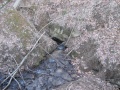
The namesake sinking waters disappearing into a hole
