Riverbank: Difference between revisions
(→Maps: Updating for new Maps extension) |
(Update IB to new format and other tweaks) |
||
| Line 1: | Line 1: | ||
<!-- The following few lines create the "Infobox" table template. Please scroll down to edit the main content of the article. --> | <!-- The following few lines create the "Infobox" table template. Please scroll down to edit the main content of the article. --> | ||
{{Infobox Trail | {{Infobox Trail | ||
| Image Name = WPSP Riverbank Trail sign.JPG | |||
| Park = Warriors Path State Park | |||
| City = Kingsport | |||
| State = Tennessee | |||
| Marking = None | |||
| Trail Use = {{Hike}} {{Dogs}} {{Fishing}} | |||
| Difficulty Rating = Easy | |||
| Hike Time = 15 Min | |||
| Round Trip Distance = 0.54 Mi | |||
| Trail Distance = 0.27 Mi | |||
| Trail Type = Segment | |||
| Elevation Gain = 153 Ft | |||
| Elevation Loss = -201 Ft | |||
| High Point = 1,362 Ft | |||
| Parking coords = 36.49870,-82.48225 | |||
| Trailhead coords = 36.49870,-82.48225 | |||
| Medical = Indian Path Hospital | |||
}} | }} | ||
<!-- End Infobox template table--> | <!-- End Infobox template table--> | ||
<!-- Start of Main Page --> | <!-- Start of Main Page --> | ||
== Trail Overview == | == Trail Overview == | ||
<!-- Enter a overview of the trail. What attracts you to this trail, points of interest, types of flowers, lakes, and peaks that you see along the way. --> | <!-- Enter a overview of the trail. What attracts you to this trail, points of interest, types of flowers, lakes, and peaks that you see along the way. --> | ||
| Line 30: | Line 31: | ||
== Route Description== | == Route Description== | ||
<!-- Detailed description of the route. Is there any side trails that are worth traveling? --> | <!-- Detailed description of the route. Is there any side trails that are worth traveling? --> | ||
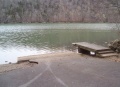
Path follows the north shoreline below the main park campground. There are dark blue trail blazes. Sometimes the route splits into an upper and lower path due to folks working their way along the steep hillside. At boat launch, can continue onto [[ | Path follows the north shoreline below the main park campground. There are dark blue trail blazes. Sometimes the route splits into an upper and lower path due to folks working their way along the steep hillside. At boat launch, can continue onto [[Trail connects to::Lakeshore|Lakeshore Trail]]. And right below Fall Creek Road at the bridge is an extremely popular fishing spot. | ||
== Typical Conditions == | == Typical Conditions == | ||
| Line 50: | Line 51: | ||
== Maps == | == Maps == | ||
<!-- You can place pictures, PDF's, links, or even create a Google map with your waypoints and place it here. --> | <!-- You can place pictures, PDF's, links, or even create a Google map with your waypoints and place it here. --> | ||
The path shown below in red is this Riverbank Trail. The section in orange is the [[ | The path shown below in red is this Riverbank Trail. The section in orange is the [[Lakeshore|Lakeshore Trail]]. | ||
<display_map center="36.5,-82.485" type="terrain" zoom="15" width="auto" height="550" gkml="http://tehcc.org/clubwiki/kml/WPSP_Riverbank_Trail.kml, | <display_map center="36.5,-82.485" type="terrain" zoom="15" width="auto" height="550" gkml="http://tehcc.org/clubwiki/kml/WPSP_Riverbank_Trail.kml, | ||
http://tehcc.org/clubwiki/kml/WPSP_Lakeshore_Trail.kml"> | http://tehcc.org/clubwiki/kml/WPSP_Lakeshore_Trail.kml"> | ||
36.50057,-82.4858~Trailhead at Fall Creek Road~ ~ | 36.50057,-82.4858~Trailhead at Fall Creek Road~ ~MarkerG.png | ||
36.49870,-82.48225~Trailhead by boat launch~ ~ | 36.49870,-82.48225~Trailhead by boat launch~ ~MarkerT.png | ||
</display_map> | </display_map> | ||
Revision as of 11:42, 27 September 2015
| |||||||||||||||||||||||||||||||||||||||||||||

Trail Overview
Located in Warriors Path State Park. A 0.27 mile walk on the sloping hillside along Ft. Patrick Henry Lake/Holston River.
How to get there
Directions to main entrance found on Warriors Path State Park webpage. There are two trailheads. One is at Fall Creek Road just south of the bridge; while the other is at the boat launch in the park campground.
Route Description
Path follows the north shoreline below the main park campground. There are dark blue trail blazes. Sometimes the route splits into an upper and lower path due to folks working their way along the steep hillside. At boat launch, can continue onto Lakeshore Trail. And right below Fall Creek Road at the bridge is an extremely popular fishing spot.
Typical Conditions
Well worn path with detours as the trees fall.
Fees, Permits, etc.
No fee required.
After the Hike
Misc. Information
The park map brochure (link below) incorrectly states 0.5 mile trail length versus 0.27 mile actual/sign information.
Maps
The path shown below in red is this Riverbank Trail. The section in orange is the Lakeshore Trail.
State Park Map and Trail Brochure
Photos
Boat Launch
