Raven Rock
Jump to navigation
Jump to search
| |||||||||||||||||||||||||||||||||||||||||||||

Trail Overview
This is part of the Roan Mountain State Park trail system
How to get there
From the Visitor's Center
- Drive south on TN143
- Park at the pool and tennis court parking lot on your right
- The trail head is on the opposite side of the street from the turn off to the campground
- Hike along the Forest Road Trail for ~0.5 miles and turn right at the sign for Raven Rock Trail
Route Description
An extension of Forest Road Trail leading to a high point lookout.
This trail is only accessible from Forest Road Trail.
Typical Conditions
Being a TN state park, the dirt and gravel trails are kept in good condition. Some of the trail sections are steep, thus can be slippery after a rain.
Misc. Information
Maps
Raven Rock Trail is shown below in its blaze color red.
Photos
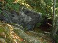
Large rock along the trail
