Raven Rock: Difference between revisions
(add kmls) |
m (move trailhead to actual spot) |
||
| (11 intermediate revisions by the same user not shown) | |||
| Line 1: | Line 1: | ||
{{Trail | |||
{{ | |Banner Image=File:Roan View from Raven Rock.jpg | ||
|Trail Highlight=Easy(ish) hike from the campground to a view of the hollow | |||
|Park=Roan Mountain State Park | |||
|Trail Marking=Red | |||
|Trail Use=Hiking, Geocaching | |||
|Trail Features=Vistas, Mountains | |||
|Difficulty Rating=Medium | |||
|Hike Time=1 hr | |||
|Trail Distance=0.9653 mi | |||
|Round Trip Distance=1.65 mi | |||
|Trail Type=Segment | |||
|High Point=3,439 ft | |||
|Low Point=2,990 ft | |||
|Elevation Gain=413 ft | |||
|Elevation Loss=441 ft | |||
|Elevation Change Direction=South-to-North | |||
|Parking location=36.15921, -82.09961 | |||
|Trailhead location=36.15982, -82.09591 | |||
}} | }} | ||
{{Trail Map|Other Trails=Forest Road}} | |||
__TOC__ | |||
== Trail Overview == | == Trail Overview == | ||
A fairly easy hike with a great lookout payoff. Use this trail as a destination or an excursion of a longer circuit using Forest Road Trail or other trails. With its proximity to the campground, anyone staying the night there should take the time for the hike and the view. | |||
== How to get there == | == How to get there == | ||
<!-- Please enter detailed instruction on how to find the trail head. --> | <!-- Please enter detailed instruction on how to find the trail head. --> | ||
From | From the [[Roan Mountain State Park#How to get there|Visitor's Center]] | ||
# | # Drive south on TN143 | ||
# | # Park at the pool and tennis court parking lot on your right | ||
# | # The trail head is on the opposite side of the street from the turn off to the campground | ||
# | # Hike along the Forest Road Trail for ~0.5 miles and turn right at the sign for Raven Rock Trail | ||
== Route Description== | == Route Description== | ||
[[File:Raven rock profile.png|thumb|right]] | |||
An extension of [[Forest Road|Forest Road Trail]] leading to a high point lookout. | An extension of [[Forest Road|Forest Road Trail]] leading to a high point lookout. | ||
Route description based on starting from Forest Road Trail head near the campground | |||
{| class="wikitable" border="1" | |||
|- | |||
!Miles Out | |||
!{{PAGENAME}} | |||
!Miles Back | |||
!Elevation (ft) | |||
|- | |||
| -0.12 | |||
|Begin at Forest Road Trail near campground | |||
|1.65 | |||
|2,940 | |||
|- | |||
|0.0 | |||
|Raven Rock Trail head | |||
|1.53 | |||
|3,052 | |||
|- | |||
|0.31 | |||
|Pass large rock hanging over trail | |||
|1.22 | |||
|3,279 | |||
|- | |||
|0.37 | |||
|Raven Rock Overlook | |||
|1.16 | |||
|3,277 | |||
|- | |||
|0.48 | |||
|Trail high point | |||
|1.05 | |||
|3,448 | |||
|- | |||
|1.02 | |||
|Re-connect with Forest Road Trail | |||
|0.51 | |||
|3,043 | |||
|- | |||
|1.41 | |||
|Re-pass the initial Raven Rock trail head | |||
|0.12 | |||
|3,052 | |||
|- | |||
|1.53 | |||
|Return to beginning | |||
|0.0 | |||
|3,052 | |||
|} | |||
This trail is only accessible from [[Trail connects to::Forest Road|Forest Road Trail]]. | This trail is only accessible from [[Trail connects to::Forest Road|Forest Road Trail]]. | ||
| Line 43: | Line 92: | ||
<!-- Typical conditions throughout the year of what to expect on the trail. Rocky, muddy, sandy, flowers, lots of downed trees? --> | <!-- Typical conditions throughout the year of what to expect on the trail. Rocky, muddy, sandy, flowers, lots of downed trees? --> | ||
Being a TN state park, the dirt and gravel trails are kept in good condition. Some of the trail sections are steep, thus can be slippery after a rain. | Being a TN state park, the dirt and gravel trails are kept in good condition. Some of the trail sections are steep, thus can be slippery after a rain. | ||
== Photos == | == Photos == | ||
{{Park trail gallery|Trail={{PAGENAME}}}} | |||
{{Map Marker | |||
|Icon Type=Point of interest | |||
Image: | |Marker Title=Large rock over trail | ||
|Marker Description=[[Image:Roan Raven Rock on the trail.jpg|150px|Large rock along the trail]] | |||
|Marker Location=36.159775,-82.093757 | |||
}} | |||
{{Map Marker | |||
|Icon Type=Overlook | |||
|Marker Title=Overlook | |||
|Marker Description=[[Image:Roan View from Raven Rock.jpg|150px|View from the outlook]] | |||
|Marker Location=36.160237,-82.093272 | |||
}} | |||
{{Map Marker | |||
|Icon Type=Point of interest | |||
|Marker Title=Trail high point | |||
|Marker Description=Trail splits, proper way marked, unknown trail the other way | |||
|Marker Location=36.159343,-82.092183 | |||
}} | |||
Latest revision as of 13:11, 28 December 2019
| Raven Rock (log in to submit report) | |
|---|---|

| |
| Highlight | Easy(ish) hike from the campground to a view of the hollow |
| Park | Roan Mountain State Park |
| Located | Roan Mountain, TennesseeLocation inherited from associated park |
| Trail Marking | Red |
| Trail UseThings allowed to do on or near the trail |
|
| FeaturesThings to see on or near the trail |
|
| Difficulty Rating | Medium |
| Hiking TimeTime from car and back. Includes any time hiking to access this trail. | 1 hr0.0625 Days <br />60 Min <br /> round trip |
| Distance: | 0.9653 mi1.553 km <br /> trailStrict non-repeating trail length / 1.65 mi2.655 km <br /> round tripTypical or shortest length from the car, hike the trail, and return to car |
| Trail Type | Segment |
| Low / High Point | 2,990 ft996.667 Yards <br />911.352 Meters <br /> / 3,439 ft1,146.333 Yards <br />1,048.207 Meters <br /> |
| Elev. Gain/LossSee link for details of calculation. Gain/Loss is direction dependent. | 413 ft125.882 Meters <br /> / (441 ft134.417 Meters <br />) – South-to-North |
| Trip ReportsFrom user "hiked it" submissions<br />Recent is within last 90 days | No hikes logged yet |
| NearbyWithin 5 mi<br />Click link to view list | 12 trails / 49.7 mi of trail |
| Parking | 36° 9' 33.16" N, 82° 5' 58.60" W Map |
| Trailhead | 36° 9' 35.35" N, 82° 5' 45.28" W Map |
|
| |
| Show In Google Maps | |
Download KML / Upload new version / KML File Page / Create Profile Chart / gpsvisualizer Map
Trail Overview[edit]
A fairly easy hike with a great lookout payoff. Use this trail as a destination or an excursion of a longer circuit using Forest Road Trail or other trails. With its proximity to the campground, anyone staying the night there should take the time for the hike and the view.
How to get there[edit]
From the Visitor's Center
- Drive south on TN143
- Park at the pool and tennis court parking lot on your right
- The trail head is on the opposite side of the street from the turn off to the campground
- Hike along the Forest Road Trail for ~0.5 miles and turn right at the sign for Raven Rock Trail
Route Description[edit]

An extension of Forest Road Trail leading to a high point lookout.
Route description based on starting from Forest Road Trail head near the campground
| Miles Out | Raven Rock | Miles Back | Elevation (ft) |
|---|---|---|---|
| -0.12 | Begin at Forest Road Trail near campground | 1.65 | 2,940 |
| 0.0 | Raven Rock Trail head | 1.53 | 3,052 |
| 0.31 | Pass large rock hanging over trail | 1.22 | 3,279 |
| 0.37 | Raven Rock Overlook | 1.16 | 3,277 |
| 0.48 | Trail high point | 1.05 | 3,448 |
| 1.02 | Re-connect with Forest Road Trail | 0.51 | 3,043 |
| 1.41 | Re-pass the initial Raven Rock trail head | 0.12 | 3,052 |
| 1.53 | Return to beginning | 0.0 | 3,052 |
This trail is only accessible from Forest Road Trail.
Typical Conditions[edit]
Being a TN state park, the dirt and gravel trails are kept in good condition. Some of the trail sections are steep, thus can be slippery after a rain.
Photos[edit]

Trail Profile
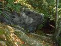
Large rock along the trail
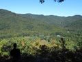
Raven Rock view
