Raven Rock: Difference between revisions
Jump to navigation
Jump to search
(→Maps: add waypoints) |
(Create trail table) |
||
| Line 9: | Line 9: | ||
| Difficulty Rating = Medium | | Difficulty Rating = Medium | ||
| Hike Time = 1 Hour | | Hike Time = 1 Hour | ||
| Round Trip Distance = 1. | | Round Trip Distance = 1.65 Mi | ||
| Trail Distance = 1. | | Trail Distance = 1.02 Mi | ||
| Trail Type = Segment | | Trail Type = Segment | ||
| Elevation Gain = 584 Ft | | Elevation Gain = 584 Ft | ||
| Elevation Loss = -595 Ft | | Elevation Loss = -595 Ft | ||
| High Point = 3, | | High Point = 3,448 Ft | ||
| Parking coords = 36.159208,-82.099615 | | Parking coords = 36.159208,-82.099615 | ||
| Trailhead coords = 36.160400,-82.097376 | | Trailhead coords = 36.160400,-82.097376 | ||
| Line 36: | Line 36: | ||
<!-- Detailed description of the route. Is there any side trails that are worth traveling? --> | <!-- Detailed description of the route. Is there any side trails that are worth traveling? --> | ||
An extension of [[Forest Road|Forest Road Trail]] leading to a high point lookout. | An extension of [[Forest Road|Forest Road Trail]] leading to a high point lookout. | ||
Route description based on starting from Forest Road Trail head near the campground | |||
{| class="wikitable" border="1" | |||
|- | |||
!Miles Out | |||
!{{PAGENAME}} | |||
!Miles Back | |||
!Elevation (ft) | |||
|- | |||
| -0.12 | |||
|Begin at Forest Road Trail near campground | |||
|1.65 | |||
|2,940 | |||
|- | |||
|0.0 | |||
|Raven Rock Trail head | |||
|1.53 | |||
|3,052 | |||
|- | |||
|0.31 | |||
|Pass large rock hanging over trail | |||
|1.22 | |||
|3,279 | |||
|- | |||
|0.37 | |||
|Raven Rock Overlook | |||
|1.16 | |||
|3,277 | |||
|- | |||
|0.48 | |||
|Trail high point | |||
|1.05 | |||
|3,448 | |||
|- | |||
|1.02 | |||
|Re-connect with Forest Road Trail | |||
|0.51 | |||
|3,043 | |||
|- | |||
|1.41 | |||
|Re-pass the initial Raven Rock trail head | |||
|0.12 | |||
|3,052 | |||
|- | |||
|1.53 | |||
|Return to beginning | |||
|0.0 | |||
|3,052 | |||
|} | |||
This trail is only accessible from [[Trail connects to::Forest Road|Forest Road Trail]]. | This trail is only accessible from [[Trail connects to::Forest Road|Forest Road Trail]]. | ||
| Line 52: | Line 101: | ||
http://tehcc.org/clubwiki/kml/RMSP_Forest_Road_Trail.kml"> | http://tehcc.org/clubwiki/kml/RMSP_Forest_Road_Trail.kml"> | ||
36.159802,-82.096066~Trail head~Connection with Forest Road Trail~MarkerG.png | 36.159802,-82.096066~Trail head~Connection with Forest Road Trail~MarkerG.png | ||
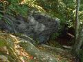
36.159775,-82.093757~Large rock~ | 36.159775,-82.093757~Large rock over trail~[[Image:Roan Raven Rock on the trail.jpg|150px|Large rock along the trail]]~MarkerG.png | ||
36.160237,-82.093272~Overlook~ ~MarkerE.png | 36.160237,-82.093272~Overlook~[[Image:Roan View from Raven Rock.jpg|150px|View from the outlook]]~MarkerE.png | ||
36.159343,-82.092183~Trail high point~Trail splits, proper way marked, unknown trail the other way~MarkerG.png | 36.159343,-82.092183~Trail high point~Trail splits, proper way marked, unknown trail the other way~MarkerG.png | ||
36.162928,-82.092131~Trail head~Connection with Forest Road Trail~MarkerG.png | 36.162928,-82.092131~Trail head~Connection with Forest Road Trail~MarkerG.png | ||
Revision as of 10:05, 26 September 2015
| |||||||||||||||||||||||||||||||||||||||||||||

Trail Overview
This is part of the Roan Mountain State Park trail system
How to get there
From the Visitor's Center
- Drive south on TN143
- Park at the pool and tennis court parking lot on your right
- The trail head is on the opposite side of the street from the turn off to the campground
- Hike along the Forest Road Trail for ~0.5 miles and turn right at the sign for Raven Rock Trail
Route Description
An extension of Forest Road Trail leading to a high point lookout.
Route description based on starting from Forest Road Trail head near the campground
| Miles Out | Raven Rock | Miles Back | Elevation (ft) |
|---|---|---|---|
| -0.12 | Begin at Forest Road Trail near campground | 1.65 | 2,940 |
| 0.0 | Raven Rock Trail head | 1.53 | 3,052 |
| 0.31 | Pass large rock hanging over trail | 1.22 | 3,279 |
| 0.37 | Raven Rock Overlook | 1.16 | 3,277 |
| 0.48 | Trail high point | 1.05 | 3,448 |
| 1.02 | Re-connect with Forest Road Trail | 0.51 | 3,043 |
| 1.41 | Re-pass the initial Raven Rock trail head | 0.12 | 3,052 |
| 1.53 | Return to beginning | 0.0 | 3,052 |
This trail is only accessible from Forest Road Trail.
Typical Conditions
Being a TN state park, the dirt and gravel trails are kept in good condition. Some of the trail sections are steep, thus can be slippery after a rain.
Misc. Information
Maps
Raven Rock Trail is shown below in its blaze color red.
Photos
Large rock along the trail
