Lakeside Trail: Difference between revisions
(→Maps: Updating for new Maps extension) |
(Cleaning up) |
||
| Line 1: | Line 1: | ||
<!-- The following few lines create the "Infobox" table template. Please scroll down to edit the main content of the article. --> | <!-- The following few lines create the "Infobox" table template. Please scroll down to edit the main content of the article. --> | ||
{{Infobox Trail | {{Infobox Trail | ||
| Image Name = Lakeside_Trail_-_Bays_Mountain_Dam.jpg | |||
| Trail Number = | |||
| Park = Bays Mountain Park | |||
| City = Kingsport | |||
| State = Tennessee | |||
| Marking = Signs | |||
| Trail Use = {{Hike}} {{Dogs}} | |||
| Difficulty Rating = Easy | |||
| Hike Time = 1.5 Hours | |||
| Round Trip Distance = 2.35 Mi | |||
| Trail Distance = 2.35 Mi | |||
| Trail Type = Loop | |||
| Elevation Gain = 775 Ft | |||
| Elevation Loss = -775 Ft | |||
| High Point = 1,974 Ft | |||
| Parking coords = 36.508821,-82.609545 | |||
| Trailhead coords = 36.508894,-82.611401 | |||
| Medical = Kingsport, TN | |||
}} | }} | ||
<!-- End Infobox template table--> | <!-- End Infobox template table--> | ||
<!-- Start of Main Page --> | <!-- Start of Main Page --> | ||
== Trail Overview == | == Trail Overview == | ||
<!-- Enter a overview of the trail. What attracts you to this trail, points of interest, types of flowers, lakes, and peaks that you see along the way. --> | <!-- Enter a overview of the trail. What attracts you to this trail, points of interest, types of flowers, lakes, and peaks that you see along the way. --> | ||
| Line 30: | Line 32: | ||
== Route Description== | == Route Description== | ||
<!-- Detailed description of the route. Is there any side trails that are worth traveling? --> | <!-- Detailed description of the route. Is there any side trails that are worth traveling? --> | ||
This trail has connections to [[Trail connects to::Bays Ridge Road]], [[Trail connects to::Lake Road (Bays Mountain Park)|Lake Road]], [[Trail connects to::Cherry Knobs Trail]], [[Trail connects to::Sweet Gum Trail]], [[Trail connects to::Food Plot Trail]], [[Trail connects to::Hemlock Trail]], [[Trail connects to::Holly Trail]], [[Trail connects to::Towhee Trail]], [[Trail connects to::Fern Trail]], and [[Trail connects to::Dolan Branch Trail]]. | |||
{| class="wikitable" border="1" | {| class="wikitable" border="1" | ||
|- | |- | ||
| Line 61: | Line 65: | ||
|- | |- | ||
|1.6 | |1.6 | ||
|Hemlock Tr./ ( | |Hemlock Tr./ (Fire Tower Trail) junction | ||
|0.8 | |0.8 | ||
|- | |- | ||
| Line 106: | Line 110: | ||
36.508894,-82.611436~Beginning of dam bridge~ ~MarkerG.png | 36.508894,-82.611436~Beginning of dam bridge~ ~MarkerG.png | ||
36.50508,-82.61732~Floating bridge~[[Image:BMP Lakeside Trail floating bridge.JPG|150px]]~MarkerL.png | 36.50508,-82.61732~Floating bridge~[[Image:BMP Lakeside Trail floating bridge.JPG|150px]]~MarkerL.png | ||
36.50578,-82.61832~Junction | 36.50578,-82.61832~Junction with [[Cherry Knobs|Cherry Knobs]]~ ~MarkerT.png | ||
36.50596,-82.62100~Fixed bridge~ ~MarkerL.png | 36.50596,-82.62100~Fixed bridge~ ~MarkerL.png | ||
36.50874,-82.62153~Fixed bridge~ ~MarkerL.png | 36.50874,-82.62153~Fixed bridge~ ~MarkerL.png | ||
| Line 129: | Line 133: | ||
<!-- Finally add the trail to any Categories it should belong to. Please keep the State category. To make a new category just type [[Category:mycategory]]. Keep in mind categories are case sensitive. --> | <!-- Finally add the trail to any Categories it should belong to. Please keep the State category. To make a new category just type [[Category:mycategory]]. Keep in mind categories are case sensitive. --> | ||
[[Category:Tennessee]] [[Category:Kingsport]] [[Category:Bays Mountain Park]] [[Category:Easy]] [[Category:Dog Friendly]] | [[Category:Tennessee]] [[Category:Kingsport]] [[Category:Bays Mountain Park]] [[Category:Easy]] [[Category:Dog Friendly]] | ||
{{#set: | |||
|Trail page needs=Detail route description;Trail pins;Update 1|+sep=; | |||
}} | |||
Revision as of 19:34, 6 October 2015
| |||||||||||||||||||||||||||||||||||||||||||||

Trail Overview
Located at Bays Mountain Park. Very popular hiking loop trail around the reservoir. It connects with many other park trails, thus a common starting point. Officially takes 90 minutes on maintained path with moderate climbs and drops. A few benches are scattered along the trail. Points of interest include floating bridge, beaver activity (dams, lodges, and down/gnawed trees), lillypad pond, and the wolves and other animal habitats. Note red dirt from maroon shale in places.
How to get there
From parking lot, either cross the dam to hike in a clockwise direction or start at back of animal habitat by the aviary area.
Route Description
This trail has connections to Bays Ridge Road, Lake Road, Cherry Knobs Trail, Sweet Gum Trail, Food Plot Trail, Hemlock Trail, Holly Trail, Towhee Trail, Fern Trail, and Dolan Branch Trail.
| Miles | Lakeside Trail | Miles |
|---|---|---|
| 0.0 | Dam, end nearest Nature Center | 2.4 |
| 0.1 | Dam, far end | 2.3 |
| 0.2 | Pine Trail junction | 2.2 |
| 0.4 | Floating Bridge | 2.0 |
| 0.5 | Cherry Knobs Trail junction | 1.9 |
| 1.1 | Beaver Pond Bridge/ Sweet Gum Trail junction | 1.3 |
| 1.6 | Hemlock Tr./ (Fire Tower Trail) junction | 0.8 |
| 1.7 | Holly Trail/ Towhee Trail junction | 0.7 |
| 1.8 | Holly Trail junction | 0.6 |
| 2.1 | Fern Trail junction | 0.3 |
| 2.3 | Water Fowl Aviary/ Laurel Trail junction | 0.1 |
| 2.4 | Nature Center | 0.0 |
Typical Conditions
The park does an excellent job keeping this most popular trail open. The path is heavily used, but sometime covered with mulch.
Regulations
NO BIKES!
Dogs are not allowed around the animal habitats, thus may have to skirt using Lake Road.
After the Hike
The animal habitats are a hit with kids of all ages.
Misc. Information
Maps
Photos
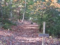
Trailhead at reservoir dam
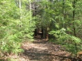
Trail thru hemlock grove
- Lakeside Trail - former avery area.jpg
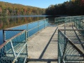
View across reservoir
Crossing the dam
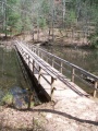
Floating bridge


