Hampton Creek Cove State Natural Area: Difference between revisions
m (add needs) |
No edit summary |
||
| Line 2: | Line 2: | ||
-->{{Infobox Trail | -->{{Infobox Trail | ||
| Image Name = | | Image Name = HCCSNA_View_Into_Hampton_Cove.jpg | ||
| City = Roan Mountain | | City = Roan Mountain | ||
| State = Tennessee | | State = Tennessee | ||
| Line 8: | Line 8: | ||
| Trail Use = {{Hike}} | | Trail Use = {{Hike}} | ||
| Difficulty Rating = Easy | | Difficulty Rating = Easy | ||
| Hike Time = | | Hike Time = 0 | ||
| Distance = | | Distance = 0 | ||
| Elevation Gain = | | Elevation Gain = 0 | ||
| High Point = | | Elevation Loss = 0 | ||
| High Point = 0 | |||
| Latitude = 36.152383 | | Latitude = 36.152383 | ||
| Longitude = -82.055733 | | Longitude = -82.055733 | ||
| Line 64: | Line 65: | ||
!Usage | !Usage | ||
|- | |- | ||
|Shell Hollow Trail | |[[Shell Hollow Trail]] | ||
| | |.75 | ||
| | | | ||
|Easy | |Easy | ||
|{{Hike}} | |{{Hike}} | ||
|- | |- | ||
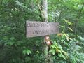
|Birchfield Trail | |[[Birchfield Trail]] | ||
| | |1.0 | ||
| | |White Vinyl Blazes | ||
|Easy | |Easy | ||
|{{Hike}} | |{{Hike}} | ||
|- | |- | ||
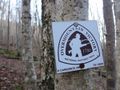
|[[Overmountain Victory National Historic Trail]] | |[[Overmountain Victory National Historic Trail]] | ||
| | |4.4 | ||
|OVNHT Icon | |OVNHT Icon | ||
|Medium | |Medium | ||
| Line 91: | Line 92: | ||
<!-- Please list any Fees, Permits, Regulations, etc. that may be required on this trail.--> | <!-- Please list any Fees, Permits, Regulations, etc. that may be required on this trail.--> | ||
No permit or fee. The nature area closes at dusk. | No permit or fee. The nature area closes at dusk. | ||
NOTE Hunting is permitted. Use precaution when hiking during hunting season | |||
== After the Hike == | == After the Hike == | ||
| Line 97: | Line 100: | ||
== Misc. Information == | == Misc. Information == | ||
<!-- Enter any additional information that doesn't fit an any other fields. Does this trail require any permits for overnight? parking? --> | <!-- Enter any additional information that doesn't fit an any other fields. Does this trail require any permits for overnight? parking? --> | ||
Hampton Creek Cove is a 693-acre natural area. The official TN.gov Hampton Creek Cove [http:// | Hampton Creek Cove is a 693-acre natural area. | ||
The official TN.gov Hampton Creek Cove [http://www.tennessee.gov/environment/article/na-na-hampton-creek-cove/ webpage]. | |||
== Maps == | == Maps == | ||
<!-- You can place pictures, PDF's, links, or even create a Google map with your waypoints and place it here. --> | |||
<display_map type="terrain" width="auto" height="600" gkml="http://tehcc.org/clubwiki/kml/HCCSNA_Birchfield_Trail.kml, | |||
http://tehcc.org/clubwiki/kml/HCCSNA_Overmountain_Shelter_Trail.kml, | |||
http://tehcc.org/clubwiki/kml/HCCSNA_Overmountain_Victory_Trail.kml, | |||
http://tehcc.org/clubwiki/kml/HCCSNA_Shell_Hollow_Trail.kml"> | |||
36.1341375787, -82.0405528418~View into Hampton Cove~[[Image:HCCSNA_View_Into_Hampton_Cove.jpg|150px]]~MarkerB.png | |||
36.1523127923, -82.0556224482~Hampton Cove Parking~ ~MarkerA.png | |||
36.1170074500, -82.0489487139~Roaring Creek Parking~ ~MarkerA.png | |||
36. | 36.1236150000, -82.0542140000~Overmountain Barn~[[Image:HCCSNA_Overmountain_Barn_From_AT.jpg|150px]]~MarkerF.png | ||
36.1489500994, -82.0430267087~Shell Cemetery~ ~MarkerN.png | |||
36.1404409560, -82.0468414829~Creek Crossing~[[Image:HCCSNA_Birchfield_Creek_Crossing.jpg|150px]]~MarkerJ.png | |||
36.1410568100, -82.0461533500~Farm Gate~[[Image:HCCSNA_Farm_Gate_01.jpg|150px]]~MarkerG.png | |||
36.1379704200, -82.0443995200~Farm Gate~[[Image:HCCSNA_Farm_Gate_02.jpg|150px]]~MarkerG.png | |||
36.1523057282, -82.0554279670~Trailhead Hampton Creek~[[Image:HCCSNA_Trailhead_Hampton_Creek.jpg|150px]]~MarkerT.png | |||
36.1168907523, -82.0486987936~Trailhead Roaring Creek~[[Image:HCCSNA_Trailhead_Roaring_Creek.jpg|150px]]~MarkerT.png | |||
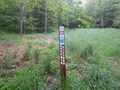
36.1255151269, -82.0512409479~Trail Junction Shelter Trail~[[Image:HCCSNA_Junctions_Shelter_Trail.jpg|150px]]~MarkerT.png | |||
36.1257587923, -82.0514537917~Yellow Mountain Gap Junction~[[Image:HCCSNA_Junctions_Yellow_Mountain_Gap.jpg|150px]]~MarkerT.png | |||
36.1353754627, -82.0425103741~Junction Birchfield Trail North~[[Image:HCCSNA_Junctions_North.jpg|150px]]~MarkerT.png | |||
36.1469884013, -82.0495906876~Junction Birchfield Trail South~[[Image:HCCSNA_Junctions_South.jpg|150px]]~MarkerT.png | |||
</display_map> | </display_map> | ||
| Line 111: | Line 130: | ||
<gallery> | <gallery> | ||
<!-- Place any pictures from this trail below. Add a picture by typing Image:imagename.extension --> | <!-- Place any pictures from this trail below. Add a picture by typing Image:imagename.extension --> | ||
Image: | Image:HCCSNA_View_Into_Hampton_Cove.jpg|View into Hampton Cove on OVNHT | ||
Image:HCCSNA_Overmountain_Barn_From_AT.jpg|Overmountain Barn viewed from the AT | |||
Image:HCCSNA_Birchfield_Creek_Crossing.jpg|Creek crossing on Birchfield Trail | |||
Image:HCCSNA_Farm_Gate_01.jpg|Farm Gate on OVNHT | |||
Image:HCCSNA_Farm_Gate_02.jpg|Farm Gate on OVNHT | |||
Image:HCCSNA_Trailhead_Hampton_Creek.jpg|Hampton Creek Trailhead | |||
Image:HCCSNA_Trailhead_Roaring_Creek.jpg|Roaring Creek Trailhead | |||
Image:HCCSNA_Junctions_Shelter_Trail.jpg|Shelter Trail Junction | |||
Image:HCCSNA_Junctions_Yellow_Mountain_Gap.jpg|Yellow Mountain Gap | |||
Image:HCCSNA_Junctions_North.jpg|Birchfield Trail North Junction | |||
Image:HCCSNA_Junctions_South.jpg|Birchfield Trail South Junction | |||
Image:HCCSNA_Blaze.jpg|Blaze | |||
<!-- Do not remove the end gallery code.--> | <!-- Do not remove the end gallery code.--> | ||
</gallery> | </gallery> | ||
Revision as of 15:34, 8 January 2016
| |||||||||||||||||||||||||||||||||||||

Trail Overview
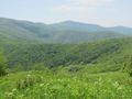
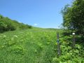
Working farm with hiking trails leading into nice forests. Important bird-watching area for rare golden-winged warblers.
How to get there
From Johnson City, TN
- Head south on Roan Street for 3.5 miles passing under I-26.
- Take left/east onto TN359/Okolona Road and travel 1.4 miles.
- Take right/south onto TN361 over to US19E for nine miles. The road starts as Laurels Road, then Dry Creek Road and finally Gap Creek Road.
- Travel US19E for ten miles to town of Roan Mountain.
- Take right/south onto TN143.
- As soon as the highway divides take left/north onto Old Highway 143.
- Turn right/east onto Hampton Creek Road and proceed three miles
- Parking area is on left/east side of road. Space available for a dozen vehicles.
Route Description
There are currently three trails in the nature area. All begin from the parking lot by following the Overmountain Trail to common junction. Shell Hollow proceeds up a dirt road past a former homestead to become a loop up on Big Ridge. Birchfield Trail follows the western side of Left Prong creek until it rejoins the Overmountain Trail, which proceeds on the eastern side of the creek but continues up Yellow Mountain to intersection with the Appalachian Trail at the gap.
| Trail | Miles | Blaze | Difficulty | Usage |
|---|---|---|---|---|
| Shell Hollow Trail | .75 | Easy | ||
| Birchfield Trail | 1.0 | White Vinyl Blazes | Easy | |
| Overmountain Victory National Historic Trail | 4.4 | OVNHT Icon | Medium |
Typical Conditions
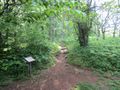
Signage for the OVNHT is adequate while those for the other two trails needs to be updated as not clear where are their lower access points. The information kiosks at several points also have badly crazed, thus should be considered for replacement.
Fees, Permits, etc.
No permit or fee. The nature area closes at dusk.
NOTE Hunting is permitted. Use precaution when hiking during hunting season
After the Hike
Misc. Information
Hampton Creek Cove is a 693-acre natural area.
The official TN.gov Hampton Creek Cove webpage.
Maps
Photos
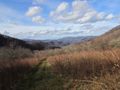
View into Hampton Cove on OVNHT
Overmountain Barn viewed from the AT
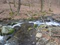
Creek crossing on Birchfield Trail
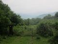
Farm Gate on OVNHT
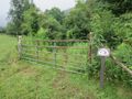
Farm Gate on OVNHT
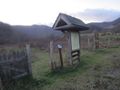
Hampton Creek Trailhead
Roaring Creek Trailhead
Shelter Trail Junction
Yellow Mountain Gap
Birchfield Trail North Junction
Birchfield Trail South Junction
Blaze


