Erwin Linear Trail: Difference between revisions
(→Maps: Added Red Bank parking pin) |
m (Text replacement - "http://tehcc.org/clubwiki/" to "https://tehcc.org/clubwiki/") |
||
| (19 intermediate revisions by 3 users not shown) | |||
| Line 1: | Line 1: | ||
<!-- The following few lines create the "Infobox" table template. Please scroll down to edit the main content of the article. --> | <!-- The following few lines create the "Infobox" table template. Please scroll down to edit the main content of the article. | ||
{{Infobox Trail | |||
| Image Name = | -->{{Infobox Trail | ||
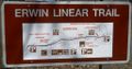
| Image Name = Erwin_Linear_Trail_sign1.JPG | |||
| City = Erwin | | City = Erwin | ||
| State = Tennessee | | State = Tennessee | ||
| Marking = | | Marking = None | ||
| Trail Use = {{Hike}} {{Biking}} {{Dogs}} | | Trail Use = {{Hike}} {{Biking}} {{Dogs}} | ||
| Difficulty Rating = Easy | | Difficulty Rating = Easy | ||
| Hike Time = 2 | | Hike Time = 2-4 | ||
| Distance = | | Distance = 4.0 | ||
| Elevation Gain = | | Elevation Gain = 210 | ||
| High Point = | | High Point = 1784 | ||
| Latitude = 36.13375 | | Latitude = 36.13375 | ||
| Longitude = -82.43283 | | Longitude = -82.43283 | ||
| Medical = Johnson City, TN | | Medical = Johnson City, TN | ||
}} | }}<!-- | ||
<!-- | |||
End Infobox template table | |||
-->{{Trail page needs | |||
| Hide needs = | |||
| KML = | |||
| Updated KML = | |||
| Detail route description = Yes | |||
| Photos = | |||
| Winter photos = | |||
| Remove prefix = | |||
| Update infobox = Yes | |||
| Infobox data update = Yes | |||
| Trail pins = | |||
| Other = | |||
| Comment = | |||
| Date reviewed = 10/24/2015 | |||
}}<!-- | |||
Start of Main Page --> | |||
== Trail Overview == | == Trail Overview == | ||
<!-- Enter overview of the trail. What attracts you to this trail, points of interest, types of flowers, lakes, and peaks that you see along the way. --> | <!-- Enter overview of the trail. What attracts you to this trail, points of interest, types of flowers, lakes, and peaks that you see along the way. --> | ||
| Line 35: | Line 52: | ||
== Route Description== | == Route Description== | ||
<!-- Detailed description of the route. Is there any side trails that are worth traveling? --> | <!-- Detailed description of the route. Is there any side trails that are worth traveling? --> | ||
Four miles of a asphalt path paralleling I-26 between Industrial Drive to Old Fishery Road. | Four miles of a asphalt path paralleling I-26 between Industrial Drive to Old Fishery Road. Mutiple access points depending upon your objective, including a playground. Essentially flat, but very slight rise when northbound. | ||
While trail signs indicate connection/parking at the north end with Erwin city park, the section under Harris Hollow Road was never built beyond a "bridge to nowhere" on the north side. Old Fishery Road is the north terminus. Likewise, the trail sign shows the southern end at the gravel parking are on Industrial Drive, but it was extended just under Jackson Love Hwy, thus allowing access to its bike path. | |||
== Typical Conditions == | == Typical Conditions == | ||
| Line 43: | Line 62: | ||
==Fees, Permits, etc. == | ==Fees, Permits, etc. == | ||
<!-- Please list any Fees, Permits, Regulations, etc. that may be required on this trail.--> | <!-- Please list any Fees, Permits, Regulations, etc. that may be required on this trail.--> | ||
Posted sign says: No Horses, No Scooters, No Skate Boards, No Roller Blades, No Motorized Vehicles ALLOWED | |||
== After the Hike == | == After the Hike == | ||
| Line 50: | Line 69: | ||
== Misc. Information == | == Misc. Information == | ||
<!-- Enter any additional information that doesn't fit an any other fields. Does this trail require any permits for overnight? parking? --> | <!-- Enter any additional information that doesn't fit an any other fields. Does this trail require any permits for overnight? parking? --> | ||
[ | [http://www.erwintn.org/departments/parks_recreation/parks_recreation.html Erwin park webpage] | ||
== Maps == | == Maps == | ||
<!-- You can place pictures, PDF's, links, or even create a Google map with your waypoints and place it here. --> | <!-- You can place pictures, PDF's, links, or even create a Google map with your waypoints and place it here. --> | ||
< | <display_map type="terrain" height="450" width="90%" gkml="https://tehcc.org/clubwiki/kml/Erwin_Linear_Trail.kml"> | ||
36.123433,-82.442750~One or two parking slots along Red Bank Drive~ ~MarkerA.png | |||
One or two parking slots along Red Bank Drive | 36.127836,-82.441763~Gravel parking area for many vehicles~ ~MarkerA.png | ||
36.133950,-82.432783~Dozen parking slots along Industrial Drive~ ~MarkerA.png | |||
36.163500,-82.397483~Booth cemetery~[[Image:Erwin Linear Trail cemetery.JPG|150px]]~MarkerN.png | |||
</ | 36.163067,-82.398083~Five to six parking spots on Old Fishery Road~[[Image:Erwin Linear Trail parking1.JPG|150px]]~MarkerA.png | ||
36.144333,-82.426633~ ~ ~MarkerO.png | |||
</display_map> | |||
== Photos == | == Photos == | ||
<gallery> | <gallery> | ||
<!-- Place any pictures from this trail below. Add a picture by typing Image:imagename.extension --> | <!-- Place any pictures from this trail below. Add a picture by typing Image:imagename.extension --> | ||
Image: | Image:Erwin Linear Trail sign2.JPG | ||
Image:Erwin Linear Trail cemetery.JPG|Booth cemetery | |||
<!-- Do not remove the end gallery code.--> | <!-- Do not remove the end gallery code.--> | ||
</gallery> | </gallery> | ||
<!-- Categories. Please keep the State category. Keep in mind categories are case sensitive. --> | <!-- Categories. Please keep the State category. Keep in mind categories are case sensitive. --> | ||
[[Category:Tennessee]] [[Category:Easy]] [[Category:Dog Friendly]] | [[Category:Tennessee]] [[Category:Easy]] [[Category:Dog Friendly]] [[Category:Biking]] | ||
Latest revision as of 12:12, 7 January 2023
| |||||||||||||||||||||||||||||||||||||

Trail Overview[edit]
A greenway along I-26 with wooded areas, natural ponds, wetlands and mountain views.
How to get there[edit]
From Johnson City, TN:
- Take I-26 south to Erwin Exit 40.
- Take left/east onto Jackson Love Highway.
- After 0.3 mile, turn left/north onto Industrial Drive.
- Just short of a mile, there will be a parking area on your left.
There are other access points, but this location is recommended for hikers as near the natural wetlands.
Route Description[edit]
Four miles of a asphalt path paralleling I-26 between Industrial Drive to Old Fishery Road. Mutiple access points depending upon your objective, including a playground. Essentially flat, but very slight rise when northbound.
While trail signs indicate connection/parking at the north end with Erwin city park, the section under Harris Hollow Road was never built beyond a "bridge to nowhere" on the north side. Old Fishery Road is the north terminus. Likewise, the trail sign shows the southern end at the gravel parking are on Industrial Drive, but it was extended just under Jackson Love Hwy, thus allowing access to its bike path.
Typical Conditions[edit]
Paved. With mostly walkers and bikers enjoying the views.
Fees, Permits, etc.[edit]
Posted sign says: No Horses, No Scooters, No Skate Boards, No Roller Blades, No Motorized Vehicles ALLOWED
After the Hike[edit]
Misc. Information[edit]
Maps[edit]
Photos[edit]
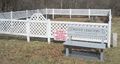
Booth cemetery

