A greenway along I-26 with wooded areas, natural ponds, wetlands and mountain views.
There are other access points, but this location is recommended for hikers as near the natural wetlands.
Four miles of a asphalt path paralleling I-26 between Industrial Drive to Old Fishery Road. Mutiple access points depending upon your objective, including a playground. Essentially flat, but very slight rise when northbound.
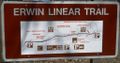
While trail signs indicate connection/parking at the north end with Erwin city park, the section under Harris Hollow Road was never built beyond a "bridge to nowhere" on the north side. Old Fishery Road is the north terminus. Likewise, the trail sign shows the southern end at the gravel parking are on Industrial Drive, but it was extended just under Jackson Love Hwy, thus allowing access to its bike path.
Paved. With mostly walkers and bikers enjoying the views.
Posted sign says: No Horses, No Scooters, No Skate Boards, No Roller Blades, No Motorized Vehicles ALLOWED
Loading map...
{"type":"TERRAIN","minzoom":false,"maxzoom":false,"types":["ROADMAP","SATELLITE","HYBRID","TERRAIN"],"mappingservice":"googlemaps3","width":"90%","height":"450px","centre":false,"title":"","label":"","icon":"","lines":[],"polygons":[],"circles":[],"rectangles":[],"copycoords":false,"static":false,"visitedicon":"","wmsoverlay":false,"zoom":false,"layers":[],"controls":["pan","zoom","type","scale","streetview","rotate"],"zoomstyle":"DEFAULT","typestyle":"DEFAULT","autoinfowindows":false,"resizable":false,"kmlrezoom":false,"poi":true,"cluster":false,"clustergridsize":60,"clustermaxzoom":20,"clusterzoomonclick":true,"clusteraveragecenter":true,"clusterminsize":2,"imageoverlays":[],"kml":[],"gkml":["https://tehcc.org/clubwiki/kml/Erwin_Linear_Trail.kml"],"searchmarkers":"","fullscreen":false,"scrollwheelzoom":false,"locations":[{"text":"\u003Cdiv class=\"mw-parser-output\"\u003E\u003Cp\u003EOne or two parking slots along Red Bank Drive\n\u003C/p\u003E\u003C/div\u003E","title":"One or two parking slots along Red Bank Drive\n","link":"","lat":36.12343299999999857163857086561620235443115234375,"lon":-82.4427500000000037516656448133289813995361328125,"icon":"/clubwiki/images/MarkerA.png"},{"text":"\u003Cdiv class=\"mw-parser-output\"\u003E\u003Cp\u003EGravel parking area for many vehicles\n\u003C/p\u003E\u003C/div\u003E","title":"Gravel parking area for many vehicles\n","link":"","lat":36.1278360000000020590960048139095306396484375,"lon":-82.4417629999999945766830933280289173126220703125,"icon":"/clubwiki/images/MarkerA.png"},{"text":"\u003Cdiv class=\"mw-parser-output\"\u003E\u003Cp\u003EDozen parking slots along Industrial Drive\n\u003C/p\u003E\u003C/div\u003E","title":"Dozen parking slots along Industrial Drive\n","link":"","lat":36.133949999999998681232682429254055023193359375,"lon":-82.432783000000000583895598538219928741455078125,"icon":"/clubwiki/images/MarkerA.png"},{"text":"\u003Cb\u003E\u003Cdiv class=\"mw-parser-output\"\u003E\u003Cp\u003EBooth cemetery\n\u003C/p\u003E\u003C/div\u003E\u003C/b\u003E\u003Cdiv class=\"mw-parser-output\"\u003E\u003Cp\u003E\u003Ca href=\"/wiki/File:Erwin_Linear_Trail_cemetery.JPG\" class=\"image\"\u003E\u003Cimg alt=\"Erwin Linear Trail cemetery.JPG\" src=\"/clubwiki/images/thumb/Erwin_Linear_Trail_cemetery.JPG/150px-Erwin_Linear_Trail_cemetery.JPG\" decoding=\"async\" width=\"150\" height=\"80\" srcset=\"/clubwiki/images/thumb/Erwin_Linear_Trail_cemetery.JPG/225px-Erwin_Linear_Trail_cemetery.JPG 1.5x, /clubwiki/images/thumb/Erwin_Linear_Trail_cemetery.JPG/300px-Erwin_Linear_Trail_cemetery.JPG 2x\" data-file-width=\"448\" data-file-height=\"240\" /\u003E\u003C/a\u003E\n\u003C/p\u003E\u003C/div\u003E","title":"Booth cemetery\n","link":"","lat":36.1634999999999990905052982270717620849609375,"lon":-82.397482999999994035533745773136615753173828125,"icon":"/clubwiki/images/MarkerN.png"},{"text":"\u003Cb\u003E\u003Cdiv class=\"mw-parser-output\"\u003E\u003Cp\u003EFive to six parking spots on Old Fishery Road\n\u003C/p\u003E\u003C/div\u003E\u003C/b\u003E\u003Cdiv class=\"mw-parser-output\"\u003E\u003Cp\u003E\u003Ca href=\"/wiki/File:Erwin_Linear_Trail_parking1.JPG\" class=\"image\"\u003E\u003Cimg alt=\"Erwin Linear Trail parking1.JPG\" src=\"/clubwiki/images/thumb/Erwin_Linear_Trail_parking1.JPG/150px-Erwin_Linear_Trail_parking1.JPG\" decoding=\"async\" width=\"150\" height=\"61\" srcset=\"/clubwiki/images/thumb/Erwin_Linear_Trail_parking1.JPG/225px-Erwin_Linear_Trail_parking1.JPG 1.5x, /clubwiki/images/thumb/Erwin_Linear_Trail_parking1.JPG/300px-Erwin_Linear_Trail_parking1.JPG 2x\" data-file-width=\"448\" data-file-height=\"183\" /\u003E\u003C/a\u003E\n\u003C/p\u003E\u003C/div\u003E","title":"Five to six parking spots on Old Fishery Road\n","link":"","lat":36.1630669999999980745997163467109203338623046875,"lon":-82.3980829999999997426129993982613086700439453125,"icon":"/clubwiki/images/MarkerA.png"},{"text":"","title":"","link":"","lat":36.1443330000000031532181310467422008514404296875,"lon":-82.4266329999999953770384308882057666778564453125,"icon":"/clubwiki/images/MarkerO.png"}]}