Dennis Cove Rd to Wilbur Dam Rd
| Dennis Cove Rd to Wilbur Dam Rd (log in to submit report) | |
|---|---|

| |
| Trail System | Appalachian Trail |
| Land Owner | Cherokee National Forest |
| Located | Roan Mountain, Tennessee |
| Trail Marking | White |
| Trail UseThings allowed to do on or near the trail |
|
| FeaturesThings to see on or near the trail |
|
| Difficulty Rating | Medium |
| Hiking TimeTime from car and back. Includes any time hiking to access this trail. | 11.5 hrs0.719 Days <br />690 Min <br /> round trip |
| Distance: | 12.8 mi20.6 km <br /> trailStrict non-repeating trail length / 25.6 mi41.199 km <br /> round tripTypical or shortest length from the car, hike the trail, and return to car |
| Trail Type | In-and-Out |
| Low / High Point | 1,950 ft650 Yards <br />594.36 Meters <br /> / 3,733 ft1,244.333 Yards <br />1,137.818 Meters <br /> |
| Elev. Gain/LossSee link for details of calculation. Gain/Loss is direction dependent. | 3,073 ft936.65 Meters <br /> / (3,332 ft1,015.594 Meters <br />) – South-to-North |
| Trip ReportsFrom user "hiked it" submissions<br />Recent is within last 90 days | 5 logged hikes (0 recent) |
| NearbyWithin 5 mi<br />Click link to view list | 4 trails / 27.8 mi of trail |
| Parking | 36° 15' 50.94" N, 82° 7' 23.74" W Map |
| Trailhead | 36° 15' 50.94" N, 82° 7' 23.74" W Map |
|
| |
| Show In Google Maps | |
Download KML / Upload new version / KML File Page / Create Profile Chart / gpsvisualizer Map
Trail Overview
How to get there
Route Description
(Trail South > North)
Dennis Cove
Road crossing at Dennis Cove and first of two access points to Hampton, TN. Dennis Cove has tent sites within walking distance of the Trail. It is the southern entrance to the Pond Mountain Wilderness and Laurel Fork Gorge.
Koonford Bridge
One of the TEHCC's most notable accomplishments, the Koonford Bridges spans Laurel Fork Creek just below a high rock wall with a number of cascades further down stream. It has received national attention and awards for it's primitive construction techniques in compliance with wilderness area restrictions.
High Water Bypass Trail
The High Water Bypass blue blaze trail is a .5 mile continuation of an old railroad grade from the AT before it descends into the Laurel Fork Gorge to the Laurel Fork Shelter. This route offers a bypass of the AT in the gorge when the area becomes flooded. It also offers a more gradual grade from the south and a small loop.
Laurel Fork Falls
One of the most dramatic falls in the entire Appalachian mountain range, the falls a great place for fly fishing and picnicking. Swimming is not allowed because of the dangerous undertow in the pool.
Laurel Fork Shelter
Laurel Fork Shelter (2450') is a stone shelter built in 1966 by the TEHCC. It is located 300' above the AT on the blue blazed bypass trail after leaving Laurel Fork Gorge.
Hampton Blue Blaze Trail
The Hampton blue blaze trail, a former AT route, is a mile long stretch of trail connecting the townships of Hampton & Braemar to the AT following an old railroad grade along Laurel Fork Creek. The trail also provides a high water route if portions of the creek side are flooded. Some of the notable features are the rocky cliffs along the creek. This route is often used by day hikers to access Laurel Fork Falls.
Pond Flats
Pond Flats (3500') is situated near the peak of Pond MOuntain in the Pond Mountain Wilderness. It hosts a rare, high elevation, naturally forming pond. It is only seen during wet seasons. There is a primitive campsite and water source here as well.
US321 - Hampton, TN and Butler, TN
This is the second and primary access point to Hampton, TN. The US321 crossing at Watauga Lake is at the Shook Branch Recreation Area. Hikers should be cautious when crossing this busy highway. There is a small parking area at the Cherokee National Forest sign.
Watauga Lake Shelter
Watauga Lake Shelter (2091') is a wooden shelter built by the United States Forest Service in 1980. it is located uphill from the AT on a blue blaze.
Watauga Dam
Watauga Dam is a 320' earthen dam built by the TVA. It holds back the Watauga River to form Watauga Lake. Access across the dam is for hiking purposes only. The Trail follows a portion of an access road that is closed to the public.
Wilbur Dam Road
This is the last access point to the Trail before the long ridge walk along Iron Mountain. It can be reached from Stoney Creek via TN91 or from Elizabethton via Siam. The road is gated during the winter approximately 2 miles from the Trail.
Photos
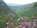
View of Laurel Fork Gorge from Potato Top
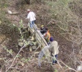
Maintainers working on the Shook Branch Bridge

View of Watauga Lake

View of Watauga Lake


