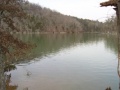
Path proceeds around the east penisula along the shoreline below the main park campground. There are no trail blazes, but the route is clear.
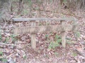
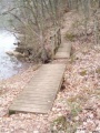
Well worn path with detours as the trees fall and shoreline crumbles into the lake. The park has installed RR ties as steps.
No fee required.
Loading map...
{"type":"TERRAIN","minzoom":false,"maxzoom":false,"types":["ROADMAP","SATELLITE","HYBRID","TERRAIN"],"mappingservice":"googlemaps3","width":"auto","height":"550px","centre":{"text":"","title":"","link":"","lat":36.4951999999999969759301166050136089324951171875,"lon":-82.480999999999994543031789362430572509765625,"icon":""},"title":"","label":"","icon":"","lines":[],"polygons":[],"circles":[],"rectangles":[],"copycoords":false,"static":false,"visitedicon":"","wmsoverlay":false,"zoom":15,"layers":[],"controls":["pan","zoom","type","scale","streetview","rotate"],"zoomstyle":"DEFAULT","typestyle":"DEFAULT","autoinfowindows":false,"resizable":false,"kmlrezoom":false,"poi":true,"cluster":false,"clustergridsize":60,"clustermaxzoom":20,"clusterzoomonclick":true,"clusteraveragecenter":true,"clusterminsize":2,"imageoverlays":[],"kml":[],"gkml":["http://tehcc.org/clubwiki/kml/WPSP_Connector_Trail.kml","http://tehcc.org/clubwiki/kml/WPSP_Lake_Hollow_Trail.kml","http://tehcc.org/clubwiki/kml/WPSP_Lakeshore_Trail.kml"],"searchmarkers":"","fullscreen":false,"scrollwheelzoom":false,"locations":[{"text":"\u003Cdiv class=\"mw-parser-output\"\u003E\u003Cp\u003EIntersection Lakeshore and Connector Trails\n\u003C/p\u003E\u003C/div\u003E","title":"Intersection Lakeshore and Connector Trails\n","link":"","lat":36.49741000000000212821760214865207672119140625,"lon":-82.4776399999999938472683425061404705047607421875,"icon":"/clubwiki/images/MarkerT.png"},{"text":"\u003Cdiv class=\"mw-parser-output\"\u003E\u003Cp\u003EIntersection Lake Hollow and Connector Trails\n\u003C/p\u003E\u003C/div\u003E","title":"Intersection Lake Hollow and Connector Trails\n","link":"","lat":36.4952899999999971214492688886821269989013671875,"lon":-82.476460000000002992237568832933902740478515625,"icon":"/clubwiki/images/MarkerT.png"},{"text":"\u003Cdiv class=\"mw-parser-output\"\u003E\u003Cp\u003EGirl Power Bench\n\u003C/p\u003E\u003C/div\u003E","title":"Girl Power Bench\n","link":"","lat":36.4966500000000024783730623312294483184814453125,"lon":-82.475650000000001682565198279917240142822265625,"icon":"/clubwiki/images/MarkerK.png"},{"text":"\u003Cdiv class=\"mw-parser-output\"\u003E\u003Cp\u003ETrail bridge\n\u003C/p\u003E\u003C/div\u003E","title":"Trail bridge\n","link":"","lat":36.497309999999998808561940677464008331298828125,"lon":-82.477339999999998099156073294579982757568359375,"icon":"/clubwiki/images/MarkerL.png"}]}