Connector: Difference between revisions
(Update IB to new format) |
(remove prefixes and trail suffixes) |
||
| Line 23: | Line 23: | ||
== Trail Overview == | == Trail Overview == | ||
<!-- Enter a overview of the trail. What attracts you to this trail, points of interest, types of flowers, lakes, and peaks that you see along the way. --> | <!-- Enter a overview of the trail. What attracts you to this trail, points of interest, types of flowers, lakes, and peaks that you see along the way. --> | ||
Located in [[Warriors Path State Park]]. Short 0.3 mile path along the shore of Ft. Patrick Henry Lake connecting [[Trail connects to:: | Located in [[Warriors Path State Park]]. Short 0.3 mile path along the shore of Ft. Patrick Henry Lake connecting [[Trail connects to::Lakeshore|Lakeshore Trail]] and [[Trail connects to::Lake Hollow|Lake Hollow Trail]], so that you can walk a loop around the park campground. | ||
== How to get there == | == How to get there == | ||
<!-- Please enter detailed instruction on how to find the trail head. --> | <!-- Please enter detailed instruction on how to find the trail head. --> | ||
Directions to main entrance found on [[Warriors Path State Park]] webpage. No direct trailhead. Reached by hiking either [[ | Directions to main entrance found on [[Warriors Path State Park]] webpage. No direct trailhead. Reached by hiking either [[Lakeshore|Lakeshore Trail]] and [[Lake Hollow|Lake Hollow Trail]]. | ||
== Route Description== | == Route Description== | ||
<!-- Detailed description of the route. Is there any side trails that are worth traveling? --> | <!-- Detailed description of the route. Is there any side trails that are worth traveling? --> | ||
Path proceeds around the east | Path proceeds around the east peninsula along the shoreline below the main park campground. There are no trail blazes, but the route is clear. | ||
== Typical Conditions == | == Typical Conditions == | ||
| Line 50: | Line 50: | ||
== Maps == | == Maps == | ||
<!-- You can place pictures, PDF's, links, or even create a Google map with your waypoints and place it here. --> | <!-- You can place pictures, PDF's, links, or even create a Google map with your waypoints and place it here. --> | ||
The path shown below in red is the [[ | The path shown below in red is the [[Lake Hollow]]. The section in dark blue is this Connector Trail. And the piece in orange is the [[Lakeshore]]. | ||
<display_map center="36.4952,-82.481" type="terrain" zoom="15" width="auto" height="550" gkml="http://tehcc.org/clubwiki/kml/WPSP_Connector_Trail.kml, | <display_map center="36.4952,-82.481" type="terrain" zoom="15" width="auto" height="550" gkml="http://tehcc.org/clubwiki/kml/WPSP_Connector_Trail.kml, | ||
Revision as of 10:48, 27 September 2015
| |||||||||||||||||||||||||||||||||||||||||||

Trail Overview
Located in Warriors Path State Park. Short 0.3 mile path along the shore of Ft. Patrick Henry Lake connecting Lakeshore Trail and Lake Hollow Trail, so that you can walk a loop around the park campground.
How to get there
Directions to main entrance found on Warriors Path State Park webpage. No direct trailhead. Reached by hiking either Lakeshore Trail and Lake Hollow Trail.
Route Description
Path proceeds around the east peninsula along the shoreline below the main park campground. There are no trail blazes, but the route is clear.
Typical Conditions
Well worn path with detours as the trees fall and shoreline crumbles into the lake. The park has installed RR ties as steps.
Fees, Permits, etc.
No fee required.
After the Hike
Misc. Information
Maps
The path shown below in red is the Lake Hollow. The section in dark blue is this Connector Trail. And the piece in orange is the Lakeshore.
State Park Map and Trail Brochure
Park brochure incorrectly lists trail distance as 0.75 miles, but is 0.3 mile.
Photos
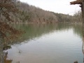
View from nice fishing spot
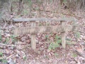
"Built by Girl Power" bench - Girls Inc
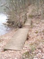
Pair of back-to-back trail bridges
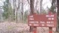
Signa at grey water disposal station


